


Summary
GOES-5, known as GOES-E before becoming operational, was a geostationary weather satellite which was operated by the United States National Oceanic and Atmospheric Administration as part of the Geostationary Operational Environmental Satellite system.[1] Launched in 1981, it was used for weather forecasting in the United States.
 Artist's impression of an HS-371 derived GOES satellite | |
| Mission type | Weather satellite |
|---|---|
| Operator | NOAA / NASA |
| COSPAR ID | 1981-049A |
| SATCAT no. | 12472 |
| Mission duration | 7 years (planned) 3 years (VISSR) 9 years (total) |
| Spacecraft properties | |
| Bus | HS-371 |
| Manufacturer | Hughes |
| Launch mass | 660 kilograms (1,460 lb) |
| Start of mission | |
| Launch date | 22 May 1981, 22:29 UTC |
| Rocket | Delta 3914 |
| Launch site | Cape Canaveral LC-17A |
| Contractor | McDonnell Douglas |
| End of mission | |
| Disposal | Decommissioned |
| Deactivated | 18 July 1990 |
| Orbital parameters | |
| Reference system | Geocentric |
| Regime | Geostationary |
| Longitude | 85° West (1981) 75° West (1981-1987) 106° West (1987-1988) 65° West (1988-1989) |
| Slot | GOES-EAST (1981-1987) |
| Semi-major axis | 42,146.0 kilometers (26,188.3 mi) |
| Perigee altitude | 35,749.8 kilometers (22,213.9 mi) |
| Apogee altitude | 35,801.1 kilometers (22,245.8 mi) |
| Inclination | 14.6 degrees |
| Period | 1,435.2 minutes |
GOES-5 was built by Hughes Space and Communications, and was based on the HS-371 satellite bus. At launch it had a mass of 660 kilograms (1,460 lb),[2] with an expected operational lifespan of around seven years.
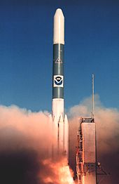
GOES-E was launched using a Delta 3914 carrier rocket[3] flying from Launch Complex 17A at the Cape Canaveral Air Force Station.[4] The launch occurred at 22:29 GMT on 22 May 1981.[5] The launch successfully placed GOES-E into a geostationary transfer orbit, from which it raised itself to geostationary orbit on 2 June by means of an onboard Star 27 apogee motor.[3][6]
Following insertion into geostationary orbit, GOES-5 was briefly placed at a longitude 85° West, however by the end of 1981, it had been moved to 75° West. It remained there until 1987, when it was moved to 106° West. In 1988 it was relocated to 65° West, where it operated until 1989.[4] The primary instrument carried aboard GOES-5, the Visible Infrared Spin-Scan Radiometer or VISSR, failed in 1984.[2] The GOES-1 and GOES-4 satellites were reactivated to fill the gap in coverage until a replacement could be launched. It was finally replaced by the ground spare, GOES-H, in 1987 after its intended replacement, GOES-G, failed to reach orbit. GOES-5 was retired to a graveyard orbit on 18 July 1990.[1][6]
See also edit
References edit
- ^ a b "GOES-5". The GOES Program - ESE 40th Anniversary. NASA. Archived from the original on 2006-10-04. Retrieved 2009-08-15.
- ^ a b "GOES-5". NSSDC Master Catalog. US National Space Science Data Center. Retrieved 2009-08-15.
- ^ a b Krebs, Gunter. "GOES-4, 5, 6, G, 7". Gunter's Space Page. Retrieved 2009-08-15.
- ^ a b Wade, Mark. "GOES". Encyclopedia Astronautica. Archived from the original on February 21, 2002. Retrieved 2009-08-15.
- ^ McDowell, Jonathan. "Launch Log". Jonathan's Space Page. Retrieved 2009-08-15.
- ^ a b McDowell, Jonathan. "Index". Geostationary Orbit Catalog. Jonathan's Space Page. Archived from the original on 2010-04-06. Retrieved 2009-08-15.