
KNOWPIA
WELCOME TO KNOWPIA

Gavarnie 
Summary
Gavarnie (French pronunciation: [ɡavaʁni]; Occitan: Gavarnia) is a former commune in the Hautes-Pyrénées department, Southwestern France.[2] On 1 January 2016, it was merged into the new commune of Gavarnie-Gèdre.[3] Gavarnie is known for the Cirque de Gavarnie, and the Gavarnie Falls in it, part of the UNESCO World Heritage Site Pyrénées – Mont Perdu.
Gavarnie | |
|---|---|
Part of Gavarnie-Gèdre | |
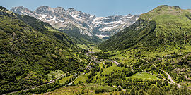 The commune of Gavarnie, and Cirque de Gavarnie | |
 Coat of arms | |
Location of Gavarnie .mw-parser-output .locmap .od{position:absolute}.mw-parser-output .locmap .id{position:absolute;line-height:0}.mw-parser-output .locmap .l0{font-size:0;position:absolute}.mw-parser-output .locmap .pv{line-height:110%;position:absolute;text-align:center}.mw-parser-output .locmap .pl{line-height:110%;position:absolute;top:-0.75em;text-align:right}.mw-parser-output .locmap .pr{line-height:110%;position:absolute;top:-0.75em;text-align:left}.mw-parser-output .locmap .pv>div{display:inline;padding:1px}.mw-parser-output .locmap .pl>div{display:inline;padding:1px;float:right}.mw-parser-output .locmap .pr>div{display:inline;padding:1px;float:left}html.skin-theme-clientpref-night .mw-parser-output .od,html.skin-theme-clientpref-night .mw-parser-output .od .pv>div,html.skin-theme-clientpref-night .mw-parser-output .od .pl>div,html.skin-theme-clientpref-night .mw-parser-output .od .pr>div{background:#000;color:#fff}html.skin-theme-clientpref-night .mw-parser-output .locmap{filter:grayscale(0.6)}@media(prefers-color-scheme:dark){html.skin-theme-clientpref-os .mw-parser-output .locmap{filter:grayscale(0.6)}html.skin-theme-clientpref-os .mw-parser-output .od,html.skin-theme-clientpref-os .mw-parser-output .od .pv>div,html.skin-theme-clientpref-os .mw-parser-output .od .pl>div,html.skin-theme-clientpref-os .mw-parser-output .od .pr>div{background:#000;color:#fff}}  Gavarnie  Gavarnie | |
| Coordinates: 42°44′06″N 0°00′36″W / 42.735°N 0.01°W | |
| Country | France |
| Region | Occitania |
| Department | Hautes-Pyrénées |
| Arrondissement | Argelès-Gazost |
| Canton | La Vallée des Gaves |
| Commune | Gavarnie-Gèdre |
| Area 1 | 82.54 km2 (31.87 sq mi) |
| Population (2019)[1] | 114 |
| • Density | 1.4/km2 (3.6/sq mi) |
| Time zone | UTC+01:00 (CET) |
| • Summer (DST) | UTC+02:00 (CEST) |
| Postal code | 65120 |
| Elevation | 1,200–3,298 m (3,937–10,820 ft) |
| 1 French Land Register data, which excludes lakes, ponds, glaciers > 1 km2 (0.386 sq mi or 247 acres) and river estuaries. | |
The Prime Meridian passes through Gavarnie, including at its southernmost point in France – the commune touches Aragon, Spain.
See also edit
References edit
Wikimedia Commons has media related to Gavarnie.