


Summary
Gaviota (Spanish for "Seagull") is an unincorporated community in Santa Barbara County, California on the Gaviota Coast about 30 miles (48 km) west of Santa Barbara and 15 miles (24 km) south of Buellton.
Gaviota, California | |
|---|---|
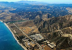 Gaviota Coast, including the oil installation and much of Gaviota State Park, 2009 | |
 Gaviota, California  Gaviota, California | |
| Coordinates: 34°28′18″N 120°12′50″W / 34.47167°N 120.21389°W | |
| Country | United States |
| State | California |
| County | Santa Barbara |
| Elevation | 102 ft (31 m) |
| Time zone | UTC-8 (Pacific (PST)) |
| • Summer (DST) | UTC-7 (PDT) |
| Area code(s) | 805 & 820 |
| GNIS feature ID | 271285[1] |

Gaviota is south and east of Gaviota State Park. The road to Hollister Ranch, the large private land holding along the coast between Gaviota and Point Conception, connects with U.S. 101 just west of Gaviota, at the turnoff to Gaviota State Park.[2][3][4]
Industries in the area include organic farming, ranching, and woodworking. Free range cattle can be seen roaming and grazing throughout the area. Gaviota is also home to a marine mammal rehabilitation center named The Channel Islands Marine & Wildlife Institute (CIMWI.org) which opened in 2006 at the historic Vista Del Mar School grounds.[5]
Gaviota was once the location of the Gaviota Marine Terminal, which is currently being decommissioned and abandoned, with intent to become public open space.[6] On the mountain side of the freeway is the Gaviota Oil Heating Facility, also known as the "Gaviota Gas Plant", built by Chevron Corp. and currently owned by Plains Exploration & Production Company (PXP); this facility is being reconfigured and partially abandoned. The former purpose of the facility was to heat and process the heavy crude oil produced offshore so that it could flow through the All American Pipeline to refineries in the Bakersfield area.[6]
Gaviota Coast edit
The Gaviota Coast remains largely undeveloped and is the longest remaining rural coastline in southern California.[7][8] In 2016, the twenty-one miles of Highway 101 that runs through the Gaviota Coast, bounded by the City of Goleta’s western boundary and Las Cruces where Route 1, was declared a State Scenic Highway.[9][10][11] The preservation of this area is the subject of "The Twenty," a film by The Surfrider Foundation.
Gaviota tarweed, a rare and endangered subspecies (subsp. villosa) of Deinandra increscens[12] endemic to Santa Barbara County, is found here.[13][14]
History edit
The first European land exploration of Alta California, the Spanish Portolà expedition, camped at Gaviota Creek on August 24, 1769 (on its way north). On the return journey to San Diego, the party again stopped there on January 6, 1770. Franciscan missionary Juan Crespi noted in his diary, "I called this place San Luis Rey, and the soldiers know it as La Gaviota, because they killed a seagull there."[15] Gaviota is the Spanish word for "seagull".[16]
Climate edit
Owing to its location on the Pacific Ocean, Gaviota has a mild, coastal Mediterranean climate, with consistent temperatures year-round. Fog is a common feature, especially during summer mornings, but usually burns off by the afternoon.
| Climate data for Gaviota, California | |||||||||||||
|---|---|---|---|---|---|---|---|---|---|---|---|---|---|
| Month | Jan | Feb | Mar | Apr | May | Jun | Jul | Aug | Sep | Oct | Nov | Dec | Year |
| Mean daily maximum °F (°C) | 62.7 (17.1) |
63.8 (17.7) |
64.4 (18.0) |
67.0 (19.4) |
68.9 (20.5) |
70.3 (21.3) |
73.0 (22.8) |
73.5 (23.1) |
73.3 (22.9) |
71.6 (22.0) |
67.7 (19.8) |
63.1 (17.3) |
68.3 (20.2) |
| Mean daily minimum °F (°C) | 42.8 (6.0) |
44.7 (7.1) |
47.0 (8.3) |
48.9 (9.4) |
52.1 (11.2) |
54.9 (12.7) |
57.7 (14.3) |
57.9 (14.4) |
56.7 (13.7) |
52.6 (11.4) |
46.7 (8.2) |
42.7 (5.9) |
50.4 (10.2) |
| Average precipitation inches (mm) | 3.70 (94) |
4.33 (110) |
3.56 (90) |
0.79 (20) |
0.30 (7.6) |
0.05 (1.3) |
0.03 (0.76) |
0.10 (2.5) |
0.41 (10) |
0.56 (14) |
1.39 (35) |
2.36 (60) |
17.58 (447) |
| Source: [17][18] | |||||||||||||
See also edit
References edit
- ^ "Yosemite Junction". Geographic Names Information System. United States Geological Survey, United States Department of the Interior.
- ^ Kettmann, Matt (December 14, 2010). "Baron Ranch Calling All Hikers". Santa Barbara Independent. Retrieved March 19, 2017.
- ^ Stewart, Ethan (February 14, 2013). "Illegal Pipes Removed". Santa Barbara Independent. Retrieved March 19, 2017.
- ^ Stewart, Ethan (November 6, 2006). "Gaviota Goes to County Supes". Santa Barbara Independent. Retrieved March 19, 2017.
- ^ Hayden, Tyler (July 11, 2011). "Hollisters Donate Last Piece of Land to Animal Rehab Center". Santa Barbara Independent.
- ^ a b "Gaviota/Arguello Abandonment project". Energy Division. County of Santa Barbara Planning and Development. Retrieved September 13, 2016.
- ^ "Final Gaviota Report". National Park Service. February 2004. Retrieved March 19, 2017.
- ^ Martinez, Alys (May 27, 2017). "El Capitan Canyon reopens following heavy winter storm damage". KEYT. Retrieved May 27, 2017.
- ^ "Announcing California's newest State Scenic Highway: Gaviota Coast State Scenic Highway". Scenic Highways. Caltrans. Archived from the original on January 3, 2017. Retrieved January 3, 2017.
- ^ "Article 2.5 of Chapter 2 of Division 1". California Streets & Highways Code. Sacramento: California Office of Legislative Counsel. Retrieved February 6, 2019.
- ^ Tallal, Jimy (October 20, 2017). "Topanga Canyon Boulevard Named State Scenic Highway". The Malibu Times. Retrieved October 21, 2017.
- ^ USFWS. Final rule for endangered status for four plants from south central coastal California. Federal Register March 20, 2000.
- ^ ssp. villosa. Jepson Manual
- ^ Bolton, Herbert E. (1927). Fray Juan Crespi: Missionary Explorer on the Pacific Coast, 1769-1774. HathiTrust Digital Library. pp. 171–172.
- ^ Gannett, Henry (1905). The Origin of Certain Place Names in the United States. Govt. Print. Off. pp. 135.
- ^ "Zipcode 93117". www.plantmaps.com. Retrieved July 26, 2023.
- ^ "Climate in Gaviota, CA". www.bestplaces.net. Retrieved July 26, 2023.