


Summary
The Gawler River is a river located in the Adelaide Plains district of the Mid North region in the Australian state of South Australia.
| Gawler Metta Watte[1] | |
|---|---|
 | |
 Location of the river mouth in South Australia | |
| Location | |
| Country | Australia |
| State | South Australia |
| Region | Mid North |
| District | Adelaide Plains |
| Towns | Gawler, Angle Vale, Virginia |
| Physical characteristics | |
| Source confluence | South Para River and North Para River |
| • location | Gawler |
| • elevation | 52 m (171 ft) |
| Mouth | Gulf St Vincent |
• location | between Port Gawler and Buckland Park |
• coordinates | 34°40′30″S 138°28′25″E / 34.6750°S 138.4737°E |
• elevation | 0 m (0 ft) |
| Length | 41 km (25 mi) |
| Basin size | 883 km2 (341 sq mi)[2] |
| Discharge | |
| • location | Port Gawler |
| • average | 10.3 gigalitres per year (8,400 acre-feet per year)[2] |
| Basin features | |
| National park | Adelaide International Bird Sanctuary |
| [3] | |
The district surrounding the river produces cereal crops and sheep for both meat and wool, as well as market gardens, almond orchards and vineyards.
Course and features edit
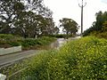
Formed by the confluence of the North Para and South Para Rivers in the town of Gawler, the river flows generally west onto the Adelaide Plains. The mouth is in the Adelaide International Bird Sanctuary National Park—Winaityinaityi Pangkara, which consists primarily of mangroves in the tidal flats as the river empties into Gulf St Vincent. The outflow represents the boundary between the suburbs of Port Gawler on the northern bank and Buckland Park on the southern bank. The river descends 50 metres (160 ft) over its 41-kilometre (25 mi) course.[3]
Flooding edit
The Gawler is subject to periodic flood events and the cause of occasional flash flooding (during 1:10 to 1:50 year flood events). Major overtopping in large floods occurs along much of the river length. Significant flooding commences within Gawler township from both the North and South Para Rivers.[4]
Angle Vale edit
-
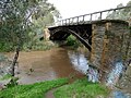
 Angle Vale Bridge
 -
 September 2010
 -
 September 2016


-
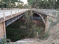 Heaslip Road Bridge
 -
 September 2016


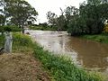
Baker Road ford, Virginia edit


September 2016[5]

See also edit
References edit
- ^ "Placename Details: Mette Watte". Property Location Browser. Land Services, Government of South Australia. 4 January 2011. SA0000252. Archived from the original on 12 October 2016. Retrieved 29 February 2016.
- ^ a b Pattiaratchi, Charitha; Jones, Rhys (July 2005). "Physical oceanographic studies of Adelaide coastal waters using high resolution modeling, in-situ observations and satellite techniques" (PDF). ACWS Technical Report No. 8 prepared for the Adelaide Coastal Waters Study Steering Committee. Centre for Water Research, University of Western Australia. Retrieved 5 June 2020.
- ^ a b "Map of Gawler River, SA". Bonzle Digital Atlas of Australia. Retrieved 25 March 2017.
- ^ Australian Water Environments (15 September 2015). "Gawler River Floodplain Mapping Report" (PDF). Gawler River Floodplain Management Authority. Retrieved 25 March 2017.
- ^ "SA weather: Gawler flooding in wake of severe storms as river levels peak". ABC News. abc.net.au. 30 September 2016. Retrieved 15 April 2017.