
KNOWPIA
WELCOME TO KNOWPIA

Gaztambide (Madrid) 
Summary
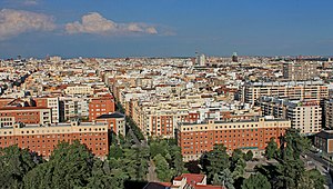
Gaztambide is an administrative neighborhood (barrio) of Madrid belonging to the district of Chamberí. It has an area of 0.506596 km2 (0.195598 sq mi).[1] As of 1 February 2021, it has a population of 23,038.[2]
Gaztambide | |
|---|---|
 | |
 | |
| Country | Spain |
| Autonomous community | Madrid |
| Municipality | Madrid |
| District | Chamberí |
| Area | |
| • Total | 0.506596 km2 (0.195598 sq mi) |
| Population | 23,038 |
| • Density | 45,000/km2 (120,000/sq mi) |
Wikimedia Commons has media related to Gaztambide neighborhood, Madrid.
References edit
- ^ "Callejero vigente. Barrios". Ayuntamiento de Madrid. Retrieved 2 March 2021.
- ^ "Población por distrito y barrio". Ayuntamiento de Madrid. Retrieved 2 March 2021.
40°26′5″N 3°42′53″W / 40.43472°N 3.71472°W