
KNOWPIA
WELCOME TO KNOWPIA

Gearhart Mountain 
Summary
Gearhart Mountain is a 8,041-foot (2,451 m) high mountain in Lake County and Klamath County, Oregon, in the United States. It is located in the Gearhart Mountain Wilderness of the Fremont–Winema National Forest, northeast of the Sprague River valley and the town of Bly.
| Gearhart Mountain | |
|---|---|
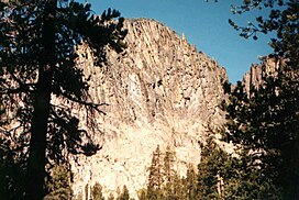 Gearhart Mountain viewed from wilderness trail | |
| Highest point | |
| Elevation | 8,041 ft (2,451 m)[1] |
| Prominence | 3,430 ft (1,050 m)[2] |
| Parent peak | Drake Peak |
| Isolation | 40.85 mi (65.74 km)[2] |
| Coordinates | 42°29′00″N 120°51′35″W / 42.48333°N 120.85972°W[1] |
| Geography | |
 Gearhart Mountain Location in the state of Oregon | |
| Location | Lake County and Klamath County, Oregon |
| Geology | |
| Age of rock | Miocene |
| Mountain type | Stratovolcano, shield volcano |
| Volcanic arc | Cascade Volcanic Arc |
| Last eruption | Miocene or younger |
Geology edit
Out of the five of them, Gearhart Mountain is the least-known shield volcano in the Eastern Cascades. Like neighboring Yamsay Mountain, it is part of the Sprague River Valley Volcanic Field
See also edit
References edit