


Summary
Geitungen Lighthouse (Norwegian: Geitungen fyr) is a coastal lighthouse in the municipality of Karmøy in Rogaland county, Norway. The lighthouse is located on a small island about 1 kilometre (0.62 mi) off the southern tip of the main island of Karmøy. The entrance to the harbor of the town of Skudeneshavn lies about 3 kilometres (1.9 mi) northeast of the lighthouse. The island is accessible only by boat. The lighthouse was established in 1924 and it was automated in 1994. It was listed as a protected site in 1998.[1][2]
 Geitungen Lighthouse | |
 | |
| Location | Karmøy Rogaland Norway |
|---|---|
| Coordinates | 59°07′53″N 05°14′34″E / 59.13139°N 5.24278°E |
| Tower | |
| Constructed | 1924 |
| Construction | masonry tower |
| Automated | 1994 |
| Height | 11.2 metres (37 ft) |
| Shape | octagonal tower |
| Markings | white tower, red lantern roof |
| Operator | Haugesund Turistforening |
| Heritage | cultural property |
| Racon | G |
| Light | |
| Focal height | 41 metres (135 ft) |
| Range | 17 nmi (31 km; 20 mi) |
| Characteristic | Oc WRG 6s. |
| Norway no. | 126500 |
Technical specifications edit
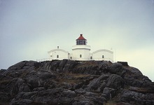
The 11-metre (36 ft) tall lighthouse emits a white, red or green light, depending on direction, occulting once every six seconds. The light sits at an elevation of 41 metres (135 ft) above sea level on top of an octagonal prism tower. The concrete masonry tower is attached to a U-shaped one-story lighthouse keeper's house. The lighthouse is painted white and the roof is red. The lighthouse also emits a racon signal, using the morse code letter "G". The racon signal can be received inside a 1.13-nautical-mile (2.09 km; 1.30 mi) radius of the lighthouse.[3][4]
History edit
The lighthouse was established in 1924 as a replacement for Skudenes Lighthouse,[5] which had operated from 1799 to 1924.[6]
Geitungen Lighthouse was designed by Jørgen H. Meinich, who later also designed Makkaur Lighthouse. The argument for a new location, was the need for a foghorn. The diaphone at Geitungen Lighthouse was the first diaphone installed in Norway.[5] Geitungen was automated and depopulated in 1994,[2] and was listed as a protected site in 1998.[1] The protected site includes the lighthouse and three technical buildings.[7]
Tourist station edit
The living house associated with Geitungen Lighthouse is operated as a tourist station by the Norwegian Trekking Association, through its Haugesund chapter (Haugesund Turistforening). It has 35 beds available for visitors. The site is only accessible by boat.[8]
See also edit
References edit
- ^ a b Godal, Anne Marit (ed.). "Geitungen fyr". Store norske leksikon (in Norwegian). Norsk nettleksikon. Retrieved 5 February 2012.
- ^ a b "Geitungen fyrstasjon" (in Norwegian). Norsk Fyrhistorisk Forening. Retrieved 5 February 2012.
- ^ Rowlett, Russ (19 July 2011). "Lighthouses of Norway: Haugesund Area (Northern Rogaland)". The Lighthouse Directory. University of North Carolina at Chapel Hill. Retrieved 1 December 2015.
- ^ Kystverket (2014). Norske Fyrliste 2014 (PDF) (in Norwegian). ISBN 9788245015959. Archived from the original (PDF) on 12 June 2018. Retrieved 2 December 2015.
- ^ a b Ersland, Bjørn Arild. "Geitungen fyr" (in Norwegian). Coast Alive. Retrieved 6 December 2015.[permanent dead link]
- ^ "Skudenes fyrstasjon" (in Norwegian). Riksantikvaren. Archived from the original on 12 July 2013. Retrieved 6 December 2015.
- ^ "Geitungen fyrstasjon" (in Norwegian). Riksantikvaren. Archived from the original on 12 July 2013. Retrieved 6 December 2015.
- ^ Rogn, Hallgrim, ed. (2012). "Geitungen Fyr". DNTs årbok 2012. Dine hytter – Del 2. Sør for Jotunheimen (in Norwegian). Den Norske Turistforening. p. 175. ISBN 978-82-8279-004-8.
External links edit
- Norsk Fyrhistorisk Forening (in Norwegian)