


Summary
Geneseo is a city in Rice County, Kansas, United States.[1] As of the 2020 census, the population of the city was 236.[3]
Geneseo, Kansas | |
|---|---|
 Flag | |
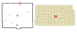 Location within Rice County and Kansas | |
 KDOT map of Rice County (legend) | |
| Coordinates: 38°31′01″N 98°09′16″W / 38.51694°N 98.15444°W[1] | |
| Country | United States |
| State | Kansas |
| County | Rice |
| Township | Victoria |
| Founded | 1886 |
| Incorporated | 1887 |
| Named for | Geneseo, Illinois |
| Area | |
| • Total | 0.58 sq mi (1.51 km2) |
| • Land | 0.58 sq mi (1.51 km2) |
| • Water | 0.00 sq mi (0.00 km2) |
| Elevation | 1,752 ft (534 m) |
| Population | |
| • Total | 236 |
| • Density | 410/sq mi (160/km2) |
| Time zone | UTC-6 (CST) |
| • Summer (DST) | UTC-5 (CDT) |
| ZIP code | 67444 |
| Area code | 620 |
| FIPS code | 20-26075 |
| GNIS ID | 2394873[1] |
History edit
For millennia, the land now known as Kansas was inhabited by Native Americans. In 1803, most of modern Kansas was secured by the United States as part of the Louisiana Purchase. In 1854, the Kansas Territory was organized, then in 1861 Kansas became the 34th U.S. state. In 1867, Rice County was founded.
Geneseo was founded in 1886.[4] It was named after Geneseo, Illinois.[5]
Geography edit
According to the United States Census Bureau, the city has a total area of 0.58 square miles (1.50 km2), all of it land.[6]
Climate edit
The climate in this area is characterized by hot, humid summers and generally mild to cool winters. According to the Köppen Climate Classification system, Geneseo has a humid subtropical climate, abbreviated "Cfa" on climate maps.[7]
Demographics edit
| Census | Pop. | Note | %± |
|---|---|---|---|
| 1890 | 399 | — | |
| 1900 | 466 | 16.8% | |
| 1910 | 566 | 21.5% | |
| 1920 | 561 | −0.9% | |
| 1930 | 536 | −4.5% | |
| 1940 | 632 | 17.9% | |
| 1950 | 660 | 4.4% | |
| 1960 | 558 | −15.5% | |
| 1970 | 453 | −18.8% | |
| 1980 | 496 | 9.5% | |
| 1990 | 382 | −23.0% | |
| 2000 | 272 | −28.8% | |
| 2010 | 267 | −1.8% | |
| 2020 | 236 | −11.6% | |
| U.S. Decennial Census | |||
2020 census edit
The 2020 United States census counted 236 people, 119 households, and 60 families in Geneseo.[8][9] The population density was 402.7 per square mile (155.5/km2). There were 135 housing units at an average density of 230.4 per square mile (88.9/km2).[9][10] The racial makeup was 88.56% (209) white or European American (86.02% non-Hispanic white), 1.27% (3) black or African-American, 0.42% (1) Native American or Alaska Native, 0.0% (0) Asian, 0.0% (0) Pacific Islander or Native Hawaiian, 0.42% (1) from other races, and 9.32% (22) from two or more races.[11] Hispanic or Latino of any race was 4.66% (11) of the population.[12]
Of the 119 households, 24.4% had children under the age of 18; 40.3% were married couples living together; 21.8% had a female householder with no spouse or partner present. 42.0% of households consisted of individuals and 19.3% had someone living alone who was 65 years of age or older.[9] The average household size was 2.0 and the average family size was 2.9.[13] The percent of those with a bachelor’s degree or higher was estimated to be 7.2% of the population.[14]
17.4% of the population was under the age of 18, 3.8% from 18 to 24, 22.0% from 25 to 44, 25.8% from 45 to 64, and 30.9% who were 65 years of age or older. The median age was 53.8 years. For every 100 females, there were 85.8 males.[9] For every 100 females ages 18 and older, there were 91.2 males.[9]
The 2016-2020 5-year American Community Survey estimates show that the median household income was $30,750 (with a margin of error of +/- $7,296) and the median family income was $31,806 (+/- $24,552).[15] Males had a median income of $40,859 (+/- $11,222) versus $27,625 (+/- $23,826) for females. The median income for those above 16 years old was $30,000 (+/- $12,471).[16] Approximately, 8.2% of families and 8.9% of the population were below the poverty line, including 4.9% of those under the age of 18 and 13.8% of those ages 65 or over.[17][18]
2010 census edit
As of the census[19] of 2010, there were 267 people, 129 households, and 73 families residing in the city. The population density was 460.3 inhabitants per square mile (177.7/km2). There were 169 housing units at an average density of 291.4 per square mile (112.5/km2). The racial makeup of the city was 95.9% White, 0.7% from other races, and 3.4% from two or more races. Hispanic or Latino of any race were 4.1% of the population.
There were 129 households, of which 16.3% had children under the age of 18 living with them, 42.6% were married couples living together, 8.5% had a female householder with no husband present, 5.4% had a male householder with no wife present, and 43.4% were non-families. 39.5% of all households were made up of individuals, and 13.9% had someone living alone who was 65 years of age or older. The average household size was 2.07 and the average family size was 2.70.
The median age in the city was 52.8 years. 17.6% of residents were under the age of 18; 4.6% were between the ages of 18 and 24; 16.8% were from 25 to 44; 39.7% were from 45 to 64; and 21.3% were 65 years of age or older. The gender makeup of the city was 57.3% male and 42.7% female.
2000 census edit
As of the census[20] of 2000, there were 272 people, 136 households, and 81 families residing in the city. The population density was 472.7 inhabitants per square mile (182.5/km2). There were 171 housing units at an average density of 297.2 per square mile (114.7/km2). The racial makeup of the city was 97.79% White, 0.37% African American, 0.74% Native American, 0.74% Asian, and 0.37% from two or more races. Hispanic or Latino of any race were 0.37% of the population.
There were 136 households, out of which 21.3% had children under the age of 18 living with them, 46.3% were married couples living together, 8.8% had a female householder with no husband present, and 40.4% were non-families. 37.5% of all households were made up of individuals, and 18.4% had someone living alone who was 65 years of age or older. The average household size was 2.00 and the average family size was 2.60.
In the city, the population was spread out, with 18.4% under the age of 18, 5.9% from 18 to 24, 20.6% from 25 to 44, 29.8% from 45 to 64, and 25.4% who were 65 years of age or older. The median age was 48 years. For every 100 females, there were 107.6 males. For every 100 females age 18 and over, there were 101.8 males.
The median income for a household in the city was $20,795, and the median income for a family was $29,250. Males had a median income of $27,083 versus $20,000 for females. The per capita income for the city was $21,998. About 8.2% of families and 9.7% of the population were below the poverty line, including 7.1% of those under the age of eighteen and 5.9% of those 65 or over.
Education edit
The community is served by Ellsworth USD 327 public school district. The district high school is located in Ellsworth. The Ellsworth High School mascot is Ellsworth Bearcats.[21]
Geneseo High School was closed through school unification in 1980. The Geneseo High School mascot was Geneseo Dragons.[22]
Media edit
- Newspaper
The Geneseo Journal was originally called the Geneseo Herald from 1887 to 1899, then it became Geneseo Post from 1908 to 1909. From 1979 through 1983 it was known as Geneseo Galaxy.[23]
Notable people edit
- John S. Gibson, Jr. - One of the nation's youngest mayors who later moved to California and became a member of the Los Angeles City Council
See also edit
References edit
- ^ a b c d U.S. Geological Survey Geographic Names Information System: Geneseo, Kansas
- ^ "2019 U.S. Gazetteer Files". United States Census Bureau. Retrieved July 24, 2020.
- ^ a b "Profile of Geneseo, Kansas in 2020". United States Census Bureau. Archived from the original on March 29, 2022. Retrieved March 29, 2022.
- ^ Kansas State Historical Society (1916). Biennial Report of the Board of Directors of the Kansas State Historical Society. Kansas State Printing Plant. pp. 273.
- ^ "Profile for Geneseo, Kansas". ePodunk. Retrieved June 22, 2014.
- ^ "US Gazetteer files 2010". United States Census Bureau. Archived from the original on January 25, 2012. Retrieved July 6, 2012.
- ^ Climate Summary for Geneseo, Kansas
- ^ "US Census Bureau, Table P16: HOUSEHOLD TYPE". data.census.gov. Retrieved January 3, 2024.
- ^ a b c d e "US Census Bureau, Table DP1: PROFILE OF GENERAL POPULATION AND HOUSING CHARACTERISTICS". data.census.gov. Retrieved January 3, 2024.
- ^ Bureau, US Census. "Gazetteer Files". Census.gov. Retrieved December 30, 2023.
- ^ "US Census Bureau, Table P1: RACE". data.census.gov. Retrieved January 3, 2024.
- ^ "US Census Bureau, Table P2: HISPANIC OR LATINO, AND NOT HISPANIC OR LATINO BY RACE". data.census.gov. Retrieved January 3, 2024.
- ^ "US Census Bureau, Table S1101: HOUSEHOLDS AND FAMILIES". data.census.gov. Retrieved January 3, 2024.
- ^ "US Census Bureau, Table S1501: EDUCATIONAL ATTAINMENT". data.census.gov. Retrieved January 3, 2024.
- ^ "US Census Bureau, Table S1903: MEDIAN INCOME IN THE PAST 12 MONTHS (IN 2020 INFLATION-ADJUSTED DOLLARS)". data.census.gov. Retrieved January 3, 2024.
- ^ "US Census Bureau, Table S2001: EARNINGS IN THE PAST 12 MONTHS (IN 2020 INFLATION-ADJUSTED DOLLARS)". data.census.gov. Retrieved January 3, 2024.
- ^ "US Census Bureau, Table S1701: POVERTY STATUS IN THE PAST 12 MONTHS". data.census.gov. Retrieved January 3, 2024.
- ^ "US Census Bureau, Table S1702: POVERTY STATUS IN THE PAST 12 MONTHS OF FAMILIES". data.census.gov. Retrieved January 3, 2024.
- ^ "U.S. Census website". United States Census Bureau. Retrieved July 6, 2012.
- ^ "U.S. Census website". United States Census Bureau. Retrieved January 31, 2008.
- ^ "USD 327". USD 327. Retrieved January 4, 2017.
- ^ "Western Kansas Basketball Results", Great Bend Tribune, 13 December 1967, p.5.
- ^ "Publications". Kansas State Historical Society. Retrieved October 15, 2009.
Further reading edit
External links edit
- Geneseo - Directory of Public Officials
- Geneseo city map, KDOT