


Summary
The geographical centre of Earth is the geometric centre of all land surfaces on Earth. Geometrically defined it is the centroid of all land surfaces within the two dimensions of the Geoid surface which approximates the Earth's outer shape. The term centre of minimum distance[1] specifies the concept more precisely as the domain is the sphere surface without boundary and not the three-dimensional body.
Explained in a different way, it is the location on the surface of Earth where the sum of distances to all locations on land is the smallest. Assuming an airplane with infinite energy and resources, if one were to fly from one start location to any location on land and back again, and repeat this from the same start location to all possible destinations, the starting location where the total travel distance is the smallest would be the geographical centre of Earth.
Its distance definition follows the shortest path on the surface of Earth along the great circle (orthodrome).
History of the concept edit


Around the world throughout history many real and illusive places were identified as axis mundi or centers of the world.
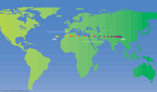
In 1864, Charles Piazzi Smyth, Astronomer Royal for Scotland, gave in his book Our Inheritance in the Great Pyramid the coordinates with 30°00′N 31°00′E / 30.000°N 31.000°E, the location of the Great Pyramid of Giza in Egypt.[3][4] He stated that this had been calculated by "carefully summing up all the dry land habitable by man all the wide world over".[3]
In October of that year, Smyth proposed to position the prime meridian at the longitude of the Great Pyramid because there it would "pass over more land than [at] any other [location]".[5] He also argued the cultural significance of the location and its vicinity to Jerusalem. The expert committee deciding the issue, however, voted for Greenwich because "so many ships used the port of London".[4]
In 1973, Andrew J. Woods, a physicist with Gulf Energy and Environmental Systems in San Diego, California, used a digital global map and calculated the coordinates on a mainframe system as 39°00′N 34°00′E / 39.000°N 34.000°E, in modern-day Turkey, near the district of Kırşehir, Seyfe Village approx. 1,800 km north of Giza.[2] In 2003, a new calculation based on a global digital elevation model obtained from satellite measurements, ETOPO2, whose data points are spaced 2′ (3.7 km at the equator) led to the result ♁ 41° N, 35° E and thus validating Wood's calculation.[6]
Differentiation from other definitions and calculations edit

Various definitions of geographical centres exists. The definition used by the references in this article refer to calculations within the 2 dimensions of a surface, mainly as the surface of Earth is the domain of human cultural existence. Other definitions refer to calculations based on three-dimensional objects, for example the Newtonian gravity centre of the whole Earth (physical barycentre) or the Newtonian gravity centre of only the continents as uniform thick three-dimensional objects. Those centres can be found inside Earth mostly near its core. A projection of those centres towards the surface would be then an alternative definition of the geographical centre, some of those calculations[8] result in a surface location projection not that far away from the geographical centre.
See also edit
- Centre of the universe (disambiguation)
- Center of population
- Center of the World
- History of the centre of the Universe
- Land and water hemispheres
- Omphalos of Delphi (ancient Greeks' navel of the Earth)
- Prime meridian – Line of longitude, at which longitude is defined to be 0°
References edit
- ^ "Geo mid point: Calculation Methods". 2022. Retrieved 16 September 2022.
- ^ a b Woods, Andrew J. (1973). The Centre of the Earth. I.C.R. Technical Monographs. Vol. 3. London: I.C.R.
- ^ a b c Smyth, Charles Piazzi (1864). Our inheritance in the Great Pyramid. London: W. Isbister & Co. pp. V, 55, 460.
- ^ a b Wilson, Colin; Rand Flem-Ath (2002). The Atlantis Blueprint: Unlocking The Ancient Mysteries Of A Long-Lost Civilization. Random House Digital, Inc. pp. 63–64. ISBN 9780307481757. Retrieved 4 May 2012.
- ^ Smyth, Charles Piazzi (1873). Royal Scottish Society of Arts (ed.). "On an Equal-Surface Projection for Maps of the World, and its Application to Certain Anthropological Questions". Transactions of the Royal Scottish Society of Arts. 8. Edinburgh: Neill & Company: 205–208, 213.
- ^ Isenberg, Holger (2003). "Giza, Centre of Earth". mars-news.de. Retrieved 27 December 2022.
- ^ Quah, Danny (2011). "The Global Economy's Shifting Centre of Gravity". Global Policy. 2 (1). Wiley: 3–9. doi:10.1111/j.1758-5899.2010.00066.x. ISSN 1758-5880. S2CID 55154148.
- ^ Huber, W (17 January 2014). "What is Centroid of all lands of Earth?" [Where is the centre of continental land area]. Stack Exchange. GIS.