


Summary
The city of Thrissur is situated in the southwest of the South Indian state of Kerala of Thrissur district. A landlocked city, Thrissur is located on a hillock which is surrounded by Thrissur Kole Wetlands. Thrissur district borders with Palakkad district in east, Malappuram district in the north, Ernakulam district in the South and Arabian Sea in the west.


Geography edit

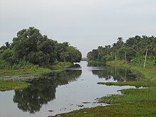
The city lies at 10°31′N 76°13′E / 10.52°N 76.21°E and has an average altitude of 2.83 metres. The city is located in midland regions of Kerala, with an extended part of Palakkad plains. It is situated in hillock, which allows rain water to automatically drain out of the city. The city geologically is composed of Archaean gneisses and crystalline schists. Major parts of city are covered by Archaean rocks. Thrissur lies near the center of the Indian tectonic plate (the Indian Plate) and is subject to comparatively little seismic or volcanic activity. The predominant topography of the city is Thrissur Kole Wetlands which extends to Malappuram district.[1][2][3] The city’s highest point is Vilangan Hills. The city is dotted with ponds and small rivers which act as a natural drainage system for the city. Peechi-Vazhani Wildlife Sanctuary in Western Ghats near Thrissur city act as a source of water for the city.

Climate edit
Under the Köppen climate classification, the city features a Tropical monsoon climate. Since the region lies in the south western coastal state of Kerala, the climate is tropical, with only minor differences in temperatures between day and night, as well as over the year. Summer lasts from March to May, and is followed by the South-west monsoon from June to September. October and November form the post monsoon or retreating monsoon season. Winter from December through February is slightly cooler, and windy, due to winds from the Western Ghats.[4] The City is drained in the monsoonal season by heavy showers. The average annual rainfall is 2500 mm. The South-west monsoon generally sets in during the last week of May. After July the rainfall decreases. On an average, there are 124 rainy days in a year. The maximum average temperature of the city in the summer season is 33 degree Celsius while the minimum temperature recorded is 22.5 degrees Celsius. The winter season records a maximum average of 29 degree Celsius and a minimum average of 20 degree Celsius.[4]
| Climate data for Thrissur | |||||||||||||
|---|---|---|---|---|---|---|---|---|---|---|---|---|---|
| Month | Jan | Feb | Mar | Apr | May | Jun | Jul | Aug | Sep | Oct | Nov | Dec | Year |
| Mean daily maximum °C (°F) | 33 (91) |
34 (93) |
36 (97) |
36 (97) |
38 (100) |
33 (91) |
33 (91) |
33 (91) |
33 (91) |
33 (91) |
34 (93) |
35 (95) |
34 (93) |
| Mean daily minimum °C (°F) | 23 (73) |
24 (75) |
25 (77) |
26 (79) |
26 (79) |
24 (75) |
24 (75) |
24 (75) |
24 (75) |
24 (75) |
24 (75) |
23 (73) |
24 (76) |
| Average precipitation mm (inches) | 32 (1.3) |
26 (1.0) |
39 (1.5) |
147 (5.8) |
391 (15.4) |
576 (22.7) |
391 (15.4) |
367 (14.4) |
417 (16.4) |
467 (18.4) |
223 (8.8) |
47 (1.9) |
3,123 (123) |
| Average precipitation days (≥ 0.1 mm) | 3 | 3 | 5 | 13 | 17 | 26 | 28 | 24 | 18 | 23 | 13 | 4 | 177 |
| Source: World Weather Online | |||||||||||||
References edit
- ^ "Geography and Climate" (PDF). ADB. Archived from the original (PDF) on 12 June 2012. Retrieved 16 June 2012.
- ^ Jose AI, Paulose S, Prameela P & Bonny BP (eds), 2002, Package of Practices Recommendations: Crops, Kerala Agricultural University "KAU Package of Practices Recommendations: Crops, 2002 - Map of Agro-ecological Zones of Kerala". Archived from the original on 19 December 2005. Retrieved 24 February 2006., Retrieved on 16 June 2012.
- ^ "Geography". Thrissur Municipal Corporation. Archived from the original on 26 April 2012. Retrieved 16 June 2012.
- ^ a b "Climate". Kerala Government. Archived from the original on 8 February 2011. Retrieved 16 June 2012.