
KNOWPIA
WELCOME TO KNOWPIA

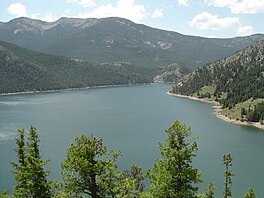
Gibson Reservoir 
Summary
Gibson Reservoir is a man-made body of water located just south of the Bob Marshall Wilderness, 20 miles (32 km) northwest of Augusta, Montana. It forms part of the county line between Teton and Lewis & Clark counties. The reservoir is formed by the concrete arch Gibson Dam and backs water up between a hilly pass for about 3 miles. The water in the dam is initially provided by spring snow runoff and carried there via the North Fork Sun River and the South Fork Sun River right after the two join. The reservoir is mainly used for irrigation control.
| Gibson Reservoir | |
|---|---|
 | |
 Gibson Reservoir | |
| Location | Teton County & Lewis & Clark County, Montana, United States |
| Coordinates | 47°36′12″N 112°45′39″W / 47.60333°N 112.76083°W[1] |
| Type | Reservoir |
| Primary inflows | South Fork Sun River North Fork Sun River |
| Primary outflows | Sun River |
| Built | 1926-1929[2] |
| Max. length | 4.5 miles (7.2 km) |
| Max. width | 3,500 feet (1,100 m) |
| Surface area | 1,288.8 acres (521.6 ha)[3] |
| Max. depth | 123 feet (37 m) |
| Water volume | 96,477 acre-feet (119,003,000 m3)[2] |
| Surface elevation | 4,869 feet (1,484 m)[1] |
Climate edit
| Climate data for Gibson Dam, Montana | |||||||||||||
|---|---|---|---|---|---|---|---|---|---|---|---|---|---|
| Month | Jan | Feb | Mar | Apr | May | Jun | Jul | Aug | Sep | Oct | Nov | Dec | Year |
| Record high °F (°C) | 67 (19) |
69 (21) |
82 (28) |
82 (28) |
90 (32) |
99 (37) |
106 (41) |
100 (38) |
96 (36) |
90 (32) |
76 (24) |
68 (20) |
106 (41) |
| Mean maximum °F (°C) | 55 (13) |
53 (12) |
61 (16) |
69 (21) |
77 (25) |
83 (28) |
91 (33) |
92 (33) |
86 (30) |
75 (24) |
61 (16) |
51 (11) |
94 (34) |
| Mean daily maximum °F (°C) | 35.4 (1.9) |
35.6 (2.0) |
42.8 (6.0) |
49.8 (9.9) |
59.4 (15.2) |
67.5 (19.7) |
78.8 (26.0) |
77.9 (25.5) |
67.7 (19.8) |
54.2 (12.3) |
41.9 (5.5) |
34.4 (1.3) |
54.6 (12.6) |
| Daily mean °F (°C) | 24.6 (−4.1) |
24.6 (−4.1) |
31.6 (−0.2) |
38.3 (3.5) |
46.7 (8.2) |
54.2 (12.3) |
62.0 (16.7) |
60.9 (16.1) |
52.6 (11.4) |
42.2 (5.7) |
32.0 (0.0) |
24.7 (−4.1) |
41.8 (5.4) |
| Mean daily minimum °F (°C) | 13.6 (−10.2) |
12.1 (−11.1) |
20.3 (−6.5) |
26.8 (−2.9) |
34.0 (1.1) |
40.8 (4.9) |
45.6 (7.6) |
44.0 (6.7) |
37.6 (3.1) |
30.1 (−1.1) |
21.9 (−5.6) |
15.1 (−9.4) |
29.0 (−1.7) |
| Mean minimum °F (°C) | −13 (−25) |
−12 (−24) |
−2 (−19) |
12 (−11) |
24 (−4) |
32 (0) |
38 (3) |
36 (2) |
27 (−3) |
12 (−11) |
−1 (−18) |
−10 (−23) |
−24 (−31) |
| Record low °F (°C) | −47 (−44) |
−49 (−45) |
−33 (−36) |
−11 (−24) |
−1 (−18) |
22 (−6) |
28 (−2) |
26 (−3) |
8 (−13) |
−13 (−25) |
−35 (−37) |
−44 (−42) |
−49 (−45) |
| Average precipitation inches (mm) | 0.65 (17) |
0.92 (23) |
0.86 (22) |
1.44 (37) |
2.74 (70) |
3.05 (77) |
1.32 (34) |
1.67 (42) |
1.53 (39) |
1.11 (28) |
0.85 (22) |
0.72 (18) |
16.86 (429) |
| Average snowfall inches (cm) | 11.6 (29) |
10.5 (27) |
10.7 (27) |
9.1 (23) |
1.6 (4.1) |
0.1 (0.25) |
0.0 (0.0) |
0.1 (0.25) |
0.8 (2.0) |
4.9 (12) |
7.3 (19) |
10.5 (27) |
67.2 (170.6) |
| Source: NOAA[4] | |||||||||||||
References edit
- ^ a b "Gibson Reservoir". Geographic Names Information System. United States Geological Survey, United States Department of the Interior.
- ^ a b "Gibson Dam". Bureau of Reclamation. Retrieved July 6, 2020.
- ^ "Gibson Reservoir". Montana Fish, Wildlife & Parks. Retrieved July 6, 2020.
- ^ Cllimate in Gibsom Dam, Montana https://www.weather.gov/wrh/Climate?wfo=tfx
External links edit
- Gibson Reservoir Bathymetric Map Archived 2020-07-07 at the Wayback Machine Montana Fish, Wildlife & Parks
Wikimedia Commons has media related to Gibson Reservoir.