


Summary
Glen Innes Severn is a local government area in the New England region of New South Wales, Australia. The council serves an area of 5,487 square kilometres (2,119 sq mi) and is located adjacent to the New England Highway. The council was formed by the amalgamation of Severn Shire and Glen Innes City Council.
| Glen Innes Severn New South Wales | |||||||||||||||
|---|---|---|---|---|---|---|---|---|---|---|---|---|---|---|---|
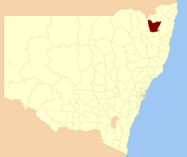 Location in New South Wales | |||||||||||||||
| Coordinates | 29°43′S 151°45′E / 29.717°S 151.750°E | ||||||||||||||
| Population |
| ||||||||||||||
| • Density | 1.61035/km2 (4.1708/sq mi) | ||||||||||||||
| Area | 5,487 km2 (2,118.5 sq mi) | ||||||||||||||
| Mayor | Robert Banham | ||||||||||||||
| Council seat | Glen Innes[3] | ||||||||||||||
| Region | New England | ||||||||||||||
| State electorate(s) | Northern Tablelands | ||||||||||||||
| Website | Glen Innes Severn | ||||||||||||||
| |||||||||||||||
The mayor of Glen Innes Severn Council is Cr. Robert Banham.
Main towns and villages edit
The council area includes the town of Glen Innes and villages including Emmaville, Deepwater, Wellingrove, Glencoe, Stonehenge and Red Range and several hamlets including Diehard, Gibraltar Range, Kingsgate and Wellington Vale.
Heritage listings edit
The Glenn Innes Servern has a number of heritage-listed sites, including:
Demographics edit
At the 2011 census, there were 8,656 people in the Glen Innes Severn local government area, of these 49.5 per cent were male and 50.5 per cent were female. Aboriginal and Torres Strait Islander people made up 5.6 per cent of the population which is approximately double both the national and state averages. The median age of people in the Glen Innes Severn Council area was 46 years; nearly ten years higher than the national median. Children aged 0 – 14 years made up 18.1 per cent of the population and people aged 65 years and over made up 22.0 per cent of the population. Of people in the area aged 15 years and over, 48.7 per cent were married and 14.1 per cent were either divorced or separated.[5]
Population growth in the Glen Innes Severn Council area between the 2001 census, the 2006 census, and the 2011 census was marginal. When compared with total population growth of Australia for the same periods, being 5.78 per cent and 8.32 per cent for each five–year period respectively, population growth in the Glen Innes Severn local government area was significantly lower than the national average.[6][7] The median weekly income for residents within the Glen Innes Severn Council area was below the national average.[5][8]
At the 2011 census, the proportion of residents in the Glen Innes Severn local government area who stated their ancestry as Australian or Anglo-Saxon exceeded 92 per cent of all residents (national average was 65.2 per cent). In excess of 69 per cent of all residents in the Glen Innes Severn Council area nominated a religious affiliation with Christianity at the 2011 census, which was significantly higher than the national average of 50.2 per cent. Meanwhile, as at the census date, compared to the national average, households in the Glen Innes Severn local government area had a significantly lower than average proportion (2.7 per cent) where two or more languages are spoken (national average was 20.4 per cent); and a significantly higher proportion (93 per cent) where English only was spoken at home (national average was 76.8 per cent).[5]
| Selected historical census data for Glen Innes Severn local government area | |||||
|---|---|---|---|---|---|
| Census year | 2001[6][7] | 2006[8] | 2011[5] | ||
| Population | Estimated residents on Census night | 8,488 | 8,780 | 8,656 | |
| LGA rank in terms of size within New South Wales | 103rd | 96th | |||
| % of New South Wales population | 0.13% | ||||
| % of Australian population | 0.05% | ||||
| Cultural and language diversity | |||||
| Ancestry, top responses |
Australian | 34.1% | |||
| English | 31.1% | ||||
| Irish | 9.8% | ||||
| Scottish | 9.4% | ||||
| German | 3.9% | ||||
| Language, top responses (other than English) |
Dutch | n/c | 0.1% | ||
| German | n/c | 0.1% | |||
| Finnish | n/c | n/c | |||
| Mandarin | n/c | n/c | |||
| Japanese | n/c | n/c | |||
| Religious affiliation | |||||
| Religious affiliation, top responses |
Anglican | n/c | 37.3% | ||
| Catholic | n/c | 22.3% | |||
| No religion | n/c | 10.4% | |||
| Uniting Church | n/c | 7.6% | |||
| Presbyterian and Reformed | n/c | 4.9% | |||
| Median weekly incomes | |||||
| Personal income | Median weekly personal income | A$337 | A$395 | ||
| % of Australian median income | 72.3% | 68.5% | |||
| Family income | Median weekly family income | A$765 | A$915 | ||
| % of Australian median income | 65.3% | 61.8% | |||
| Household income | Median weekly household income | A$613 | A$734 | ||
| % of Australian median income | 59.7% | 59.5% | |||
Council edit
Current composition and election method edit
Glen Innes Severn Council is composed of seven councillors elected proportionally as a single ward. All councillors are elected for a fixed four-year term of office. The mayor is elected by the councillors at the first meeting of the council. The most recent election was held in December 2021, and the makeup of the council is as follows:[9]
| Party | Councillors | |
|---|---|---|
| Independents and unaligned | 6 | |
| The Greens | 1 | |
| Total | 7 | |
The current Council, elected in 2021, in order of election, is:[9]
| Councillor | Party | Notes | |
|---|---|---|---|
| Rob Banham | Independent | Mayor[10] | |
| Troy Arandale | Independent | ||
| Tim Alt | Independent | ||
| Lara Gresham | Independent | ||
| Carol Sparks | The Greens | ||
| Jack Parry | Independent | ||
| Andrew Parsons | Independent | ||
2021 election results edit
| Party | Candidate | Votes | % | ±% | |
|---|---|---|---|---|---|
| Independent | Rob Banham (elected) | 1,066 | 19.4 | ||
| Greens | Carol Sparks (elected) | 638 | 11.6 | ||
| Independent | Troy Arandale (elected) | 637 | 11.6 | ||
| Independent | Timothy Alt (elected) | 612 | 11.1 | ||
| Independent | Jack Parry (elected) | 534 | 9.7 | ||
| Independent | Lara Gresham (elected) | 389 | 7.1 | ||
| Independent | Andrew Parsons (elected) | 311 | 5.7 | ||
| Independent | Jeff Smith | 298 | 5.4 | ||
| Independent | Benjamin Thorpe | 223 | 4.1 | ||
| Independent | Richard Moon | 207 | 3.8 | ||
| Independent | Dianne Newman | 177 | 3.2 | ||
| Independent | Sheryn Nourse | 177 | 3.2 | ||
| Independent | Rosemary Curtis | 173 | 3.1 | ||
| Independent | David Renn | 54 | 1.0 | ||
| Total formal votes | 5,496 | 97.2 | |||
| Informal votes | 161 | 2.8 | |||
| Turnout | 5,657 | 90.4 | |||
References edit
- ^ Australian Bureau of Statistics (27 June 2017). "Glen Innes Severn (A)". 2016 Census QuickStats. Retrieved 8 December 2017.
- ^ "3218.0 – Regional Population Growth, Australia, 2017–18". Australian Bureau of Statistics. 27 March 2019. Retrieved 27 March 2019. Estimated resident population (ERP) at 30 June 2018.
- ^ "Glen Innes Severn Council". Division of Local Government. Retrieved 2 December 2006.
- ^ "High Conservation Value Old Growth forest". New South Wales State Heritage Register. Department of Planning & Environment. H01487. Retrieved 18 May 2018.
 Text is licensed by State of New South Wales (Department of Planning and Environment) under CC-BY 4.0 licence.
- ^ a b c d Australian Bureau of Statistics (31 October 2012). "Glen Innes Severn (A)". 2011 Census QuickStats. Retrieved 7 January 2015.
- ^ a b Australian Bureau of Statistics (9 March 2006). "Glen Innes (A)". 2001 Census QuickStats. Retrieved 7 January 2015.
- ^ a b Australian Bureau of Statistics (9 March 2006). "Severn (A)". 2001 Census QuickStats. Retrieved 7 January 2015.
- ^ a b Australian Bureau of Statistics (25 October 2007). "Glen Innes Severn (A)". 2006 Census QuickStats. Retrieved 7 January 2015.
- ^ a b "Glen Innes Severn Council: Summary of First Preference and Group Votes for each Candidate". Local Government Elections 2016. Electoral Commission of New South Wales. 16 September 2016. Retrieved 20 October 2016.
- ^ Thomson, Craig (23 September 2016). "Upset result in Glen Innes Severn Council mayoral election". Northern Daily Leader. Australia. Retrieved 20 October 2016.
- ^ "Glen Innes Severn Shire". ABC News.