


Summary
Glenasmole (Irish: Gleann an Smóil) is a valley in the Dublin Mountains in the south of County Dublin, Ireland. The valley itself is around 200 m (660 ft) in elevation and is surrounded by mountains exceeding 600 m (2,000 ft) in elevation. Kippure, at 757 m (2,484 ft), is the highest mountain along the valley ridge and is also the highest point in County Dublin. The River Dodder rises at Kippure and flows through the valley, reaching the sea at Dublin Bay.[1] The Glenasmole Valley is an EU-designated Special Area of Conservation.[2]
Glenasmole
Gleann an Smóil | |
|---|---|
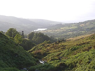 The valley looking north along the River Dodder, the Bohernabreena Reservoir can be seen in the distance | |
| Coordinates: 53°13′59″N 6°21′23″W / 53.233010°N 6.356268°W | |
| Location | County Dublin, Ireland |
| Range | Dublin Mountains |
| Part of | Wicklow Mountains |
| Highest elevation | 757 m (2,484 ft) (Kippure) |
The Dodder feeds the two reservoirs at the centre of the valley, known as the Bohernabreena Reservoirs (Irish: Taiscumar Bóthar na Bruíne). The reservoirs, constructed between 1883 and 1887, supply 18.2 million litres of water per day. Despite being within South Dublin's local authority area, the reservoirs and accompanying waterworks are owned and operated by Dublin City Council.[3]

The area around the valley is rural in nature and has a population of 415 according to the 2016 Census. There are no nucleated villages in the valley as most dwellings are one-off houses. The small area encompassing the valley covers 30 square kilometres (7,413 acres), giving it a population density of 14.9 people per square km, making it the most sparsely populated region in County Dublin.[4]
References edit
- ^ Strategic Environmental Assessment – Scoping Report (PDF) (Report). Dublin City Council. June 2008. p. 13. Archived from the original (PDF) on 13 June 2011. Retrieved 17 August 2010.
- ^ "Glenasmole Valley SAC". National Parks and Wildlife Service. Retrieved 6 October 2022.
- ^ "Glenasmole". Retrieved 31 October 2021.
- ^ "AIRO Maynooth 2016 Census Mapping". Retrieved 31 October 2021.