


Summary
Godewaersvelde (French pronunciation: [ɡɔdvaʁsvɛld]; French Flemish: Godsvelde) is a commune in the Nord department in northern France, near the Belgian border.[3]
Godewaersvelde | |
|---|---|
 The old railway station and church | |
 Coat of arms | |
Location of Godewaersvelde .mw-parser-output .locmap .od{position:absolute}.mw-parser-output .locmap .id{position:absolute;line-height:0}.mw-parser-output .locmap .l0{font-size:0;position:absolute}.mw-parser-output .locmap .pv{line-height:110%;position:absolute;text-align:center}.mw-parser-output .locmap .pl{line-height:110%;position:absolute;top:-0.75em;text-align:right}.mw-parser-output .locmap .pr{line-height:110%;position:absolute;top:-0.75em;text-align:left}.mw-parser-output .locmap .pv>div{display:inline;padding:1px}.mw-parser-output .locmap .pl>div{display:inline;padding:1px;float:right}.mw-parser-output .locmap .pr>div{display:inline;padding:1px;float:left}html.skin-theme-clientpref-night .mw-parser-output .od,html.skin-theme-clientpref-night .mw-parser-output .od .pv>div,html.skin-theme-clientpref-night .mw-parser-output .od .pl>div,html.skin-theme-clientpref-night .mw-parser-output .od .pr>div{background:#000;color:#fff}html.skin-theme-clientpref-night .mw-parser-output .locmap{filter:grayscale(0.6)}@media(prefers-color-scheme:dark){html.skin-theme-clientpref-os .mw-parser-output .locmap{filter:grayscale(0.6)}html.skin-theme-clientpref-os .mw-parser-output .od,html.skin-theme-clientpref-os .mw-parser-output .od .pv>div,html.skin-theme-clientpref-os .mw-parser-output .od .pl>div,html.skin-theme-clientpref-os .mw-parser-output .od .pr>div{background:#000;color:#fff}}  Godewaersvelde  Godewaersvelde | |
| Coordinates: 50°47′41″N 2°38′39″E / 50.7947°N 2.6442°E | |
| Country | France |
| Region | Hauts-de-France |
| Department | Nord |
| Arrondissement | Dunkerque |
| Canton | Bailleul |
| Intercommunality | CC Flandre Intérieure |
| Government | |
| • Mayor (2020–2026) | Antoine Vermeulen[1] |
| Area 1 | 11.89 km2 (4.59 sq mi) |
| Population (2021)[2] | 2,053 |
| • Density | 170/km2 (450/sq mi) |
| Demonym | Godewaersveldois (es) |
| Time zone | UTC+01:00 (CET) |
| • Summer (DST) | UTC+02:00 (CEST) |
| INSEE/Postal code | 59262 /59270 |
| Elevation | 27–163 m (89–535 ft) (avg. 41 m or 135 ft) |
| 1 French Land Register data, which excludes lakes, ponds, glaciers > 1 km2 (0.386 sq mi or 247 acres) and river estuaries. | |
Location edit
Godewaersvelde is in northern France along the Belgian border and is in the heart of Flanders, less than half an hour from Lille and Dunkirk. Godewaersvelde covers 1189 hectares or nearly 12 square kilometers and is crossed by several county roads: the R & D 948 which connects at the A25 interchange in Poperinge, 139 R & D that leads to Boeschèpe and Eecke, DR 18, which connects Route Méteren to Poperinge.
Population edit
| Year | Pop. | ±% p.a. |
|---|---|---|
| 1968 | 1,798 | — |
| 1975 | 1,665 | −1.09% |
| 1982 | 1,713 | +0.41% |
| 1990 | 1,738 | +0.18% |
| 1999 | 1,927 | +1.15% |
| 2007 | 1,964 | +0.24% |
| 2012 | 2,016 | +0.52% |
| 2017 | 2,051 | +0.34% |
| Source: INSEE[4] | ||
Heraldry edit
 |
The arms of Godewaersvelde are blazoned : Barry gules and vair.
|
Etymology edit
The name of the commune means "Godafritha's Heath" or "Godefried Fields".
British soldiers called it "God" during the First World War. A popular story claims that Godewaersvelde means "God bless our fields", but it appears to be unfounded, and is dismissed by linguists and historians.
Another WWI troop nickname was "Gerty Wears Velvet".[5]
- 1295-1296: Gaudefroit camp
- 1300: Godeverdesvelde
- 1318: Godefroichamp[6]
- 1918: Goedesversvelde (in WWI news in newspapers)
Dutch: Godewaarsvelde; Frans-Vlaams: Godsvelde; official French: Godewaersvelde is in Franse Westhoek, in the Nord Department, France. The community has 2000 dwellers. In the place where French Flemish dialect and in the Westhoek becoming known as Godsvelde is spoken.
See also edit
Gallery edit
-

-
 Chapel of Saint Bernard of the Abbaye du Mont des Cats
 -
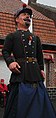 "Henri le douanier", giant


References edit
- ^ "Répertoire national des élus: les maires" (in French). data.gouv.fr, Plateforme ouverte des données publiques françaises. 13 September 2022.
- ^ "Populations légales 2021". The National Institute of Statistics and Economic Studies. 28 December 2023.
- ^ INSEE commune file
- ^ Population en historique depuis 1968, INSEE
- ^ Daily Telegraph, Saturday 27 April 1918, reprinted in page 32, Daily Telegraph, Friday 27 April 2018; see English-language names given by WWI troops to places affected by WWI
- ^ Sources: Jozef van Overstraeten1 see also La Voix du Nord, News / Hazebrouck / Page 4 / Article 2 Edition Sunday, April 24, 2005