


Summary
The Golden Hinde is a mountain located in the Vancouver Island Ranges on Vancouver Island, British Columbia, Canada. At 2,195 metres (7,201 ft),[3] it is the highest peak on the island. The peak is popular with experienced backcountry-climbers, having been first ascended in 1913. The mountain is made of basalt which is part of the Karmutsen Formation.[4]
| Golden Hinde | |
|---|---|
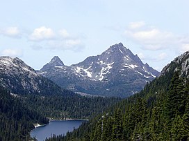 Golden Hinde, south aspect, August 2006. | |
| Highest point | |
| Elevation | 2,195 m (7,201 ft)[1] |
| Prominence | 2,195 m (7,201 ft)[1] |
| Listing | |
| Coordinates | 49°39′46″N 125°44′49″W / 49.66278°N 125.74694°W[2] |
| Geography | |
 Golden Hinde British Columbia, Canada  Golden Hinde Golden Hinde (British Columbia) | |
| Location | Vancouver Island, British Columbia, Canada |
| District | Nootka Land District |
| Parent range | Vancouver Island Ranges |
| Topo map | NTS 92F12 Buttle Lake |
| Climbing | |
| First ascent | Einar Anderson, W.R. Kent 1913 or 1914 |
| Easiest route | rock climb |
Geography edit
The mountain is located near the geographic centre of Vancouver Island, as well as near the centre of 2,450 km2 (605,408 acres) Strathcona Provincial Park, at the head of the Wolf River and to the west of Buttle Lake, about 25 kilometres (16 mi) east of the community of Gold River.
Name origin edit
The mountain took its name from Sir Francis Drake's ship, the Golden Hind, by an early fur-trading captain, who was reminded of Drake's ship as sunset hit the mountain (which is visible from the west coast of the Island) and in honour of Drake's reputed presence off the coast of the future British Columbia during the explorer's circumnavigation of the globe from 1577 to 1580 (see New Albion).
The present name was not officially conferred until 1938, but this was done after a reference to the peak in a fur-trader's log. The alternative name "The Rooster's Comb" was used by early alpinists because of the mountain's appearance.[5]
See also edit
References edit
- ^ a b "British Columbia and Alberta: The Ultra-Prominence Page". Peaklist.org. Retrieved 2013-01-09.
- ^ "Golden Hinde, British Columbia". Peakbagger.com. Retrieved 2013-01-09.
- ^ Different sources list slightly different values for the maximum elevation above sea level. A recent survey using GPS determined the NAS83 elevation as 2,196.818 m. See "Golden Hinde". BC Geographical Names. for a discussion; see [1] for description of the trip to obtain this value
- ^ Geology of Strathcona Park - The Volcanic Flood Archived 2012-07-29 at archive.today Retrieved 24 November 2007
- ^ Akrigg, G.P.V. and Helen Akrigg. "Golden Hinde." British Columbia Place Names. Vancouver: UBC Press, 1997. p. 94
External links edit
 Definitions from Wiktionary
 Media from Commons
 News from Wikinews
 Quotations from Wikiquote
 Texts from Wikisource
 Textbooks from Wikibooks
 Resources from Wikiversity
- "Golden Hinde". BC Geographical Names.
- Strathcona Provincial Park from British Columbia Ministry of Environment website.
- "Golden Hinde". Bivouac.com..
- Elite Backpacking - Guiding company specializing in the Golden Hinde