
KNOWPIA
WELCOME TO KNOWPIA

Gorodetsky District 
Summary
Gorodetsky District (Russian: Городе́цкий райо́н) is an administrative district (raion), one of the forty in Nizhny Novgorod Oblast, Russia.[1] Municipally, it is incorporated as Gorodetsky Municipal District.[5] It is located in the west of the oblast. The area of the district is 1,473.7 square kilometers (569.0 sq mi).[1] Its administrative center is the town of Gorodets.[1] Population: 91,577 (2010 Census);[2]64,700 (2002 Census);[7] 69,451 (1989 Census).[8] The population of Gorodets accounts for 33.5% of the district's total population.[2]
Gorodetsky District
Городецкий район | |
|---|---|
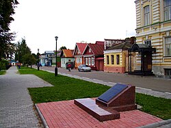 Gorodets, the administrative center of Gorodetsky District | |
 Flag  Coat of arms | |
 Location of Gorodetsky District in Nizhny Novgorod Oblast | |
| Coordinates: 56°39′N 43°29′E / 56.650°N 43.483°E | |
| Country | Russia |
| Federal subject | Nizhny Novgorod Oblast[1] |
| Established | 1929[1] |
| Administrative center | Gorodets[1] |
| Area | |
| • Total | 1,473.7 km2 (569.0 sq mi) |
| Population | |
| • Total | 91,577 |
| • Estimate (2018)[3] | 87,208 (−4.8%) |
| • Density | 62/km2 (160/sq mi) |
| • Urban | 79.3% |
| • Rural | 20.7% |
| Administrative structure | |
| • Administrative divisions | 2 Towns of district significance, 1 Work settlements, 9 Selsoviets |
| • Inhabited localities[1] | 2 cities/towns, 1 Urban-type settlements[4], 434 rural localities |
| Municipal structure | |
| • Municipally incorporated as | Gorodetsky Municipal District[5] |
| • Municipal divisions[5] | 3 urban settlements, 9 rural settlements |
| Time zone | UTC+3 (MSK |
| OKTMO ID | 22628000 |
| Website | http://www.gorodets-adm.ru |
History edit
The district was established in 1929.[1]
Notable residents edit
- Alexander Semyonovich Vedernikov (1898–1975), artist
References edit
Notes edit
- ^ a b c d e f g h i Order #3-od
- ^ a b c Russian Federal State Statistics Service (2011). Всероссийская перепись населения 2010 года. Том 1 [2010 All-Russian Population Census, vol. 1]. Всероссийская перепись населения 2010 года [2010 All-Russia Population Census] (in Russian). Federal State Statistics Service.
- ^ "26. Численность постоянного населения Российской Федерации по муниципальным образованиям на 1 января 2018 года". Federal State Statistics Service. Retrieved January 23, 2019.
- ^ The count of urban-type settlements may include the work settlements, the resort settlements, the suburban (dacha) settlements, as well as urban-type settlements proper.
- ^ a b c Resolution #670
- ^ "Об исчислении времени". Официальный интернет-портал правовой информации (in Russian). June 3, 2011. Retrieved January 19, 2019.
- ^ Russian Federal State Statistics Service (May 21, 2004). Численность населения России, субъектов Российской Федерации в составе федеральных округов, районов, городских поселений, сельских населённых пунктов – районных центров и сельских населённых пунктов с населением 3 тысячи и более человек [Population of Russia, Its Federal Districts, Federal Subjects, Districts, Urban Localities, Rural Localities—Administrative Centers, and Rural Localities with Population of Over 3,000] (XLS). Всероссийская перепись населения 2002 года [All-Russia Population Census of 2002] (in Russian).
- ^ Всесоюзная перепись населения 1989 г. Численность наличного населения союзных и автономных республик, автономных областей и округов, краёв, областей, районов, городских поселений и сёл-райцентров [All Union Population Census of 1989: Present Population of Union and Autonomous Republics, Autonomous Oblasts and Okrugs, Krais, Oblasts, Districts, Urban Settlements, and Villages Serving as District Administrative Centers]. Всесоюзная перепись населения 1989 года [All-Union Population Census of 1989] (in Russian). Институт демографии Национального исследовательского университета: Высшая школа экономики [Institute of Demography at the National Research University: Higher School of Economics]. 1989 – via Demoscope Weekly.
Sources edit
- Государственно-правовой департамент Нижегородской области. Приказ №3-од от 27 января 2016 г. «Об утверждении реестра административно-территориальных образований, городских и сельских населённых пунктов Нижегородской области». Опубликован: "Нижегородская правда", №27(26048) (начало) и №30 (26051) (окончание), 19 и 26 марта 2016 г. (State Legal Department of Nizhny Novgorod Oblast. Order #3-od of January 27, 2016 On the Adoption of the Registry of the Administrative-Territorial Formations, Urban and Rural Localities of Nizhny Novgorod Oblast. ).
- Правительство Нижегородской области. Постановление №670 от 11 сентября 2009 г. «О перечне муниципальных образований Нижегородской области», в ред. Постановления №587 от 29 августа 2014 г. «О внесении изменений в перечень муниципальных образований Нижегородской области, утверждённый Постановлением Правительства Нижегородской области от 11 сентября 2009 г. №670». Опубликован: "Нижегородские новости", №177(4309), 1 октября 2009 г. (Government of Nizhny Novgorod Oblast. Resolution #670 of September 11, 2009 On the Registry of the Municipal Formations of Nizhny Novgorod Oblast, as amended by the Resolution #587 of August 29, 2004 On Amending the Registry of the Municipal Formations of Nizhny Novgorod Oblast, Adopted by Resolution #670 of the Government of Nizhny Novgorod Oblast of September 11, 2009. ).