
KNOWPIA
WELCOME TO KNOWPIA

Goult 
Summary
Goult (French pronunciation: [ɡult]; Occitan: Gòud) is a commune in the Vaucluse department in the Provence-Alpes-Côte d'Azur region in Southeastern France. In 2021, it had a population of 1,080. The village is perched on a hill with a solitary road to the peak. Near the end of the road is a 12th-century castle, the Château de Goult.
Goult
Gòud (Occitan) | |
|---|---|
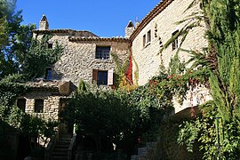 Village centre | |
 Coat of arms | |
Location of Goult .mw-parser-output .locmap .od{position:absolute}.mw-parser-output .locmap .id{position:absolute;line-height:0}.mw-parser-output .locmap .l0{font-size:0;position:absolute}.mw-parser-output .locmap .pv{line-height:110%;position:absolute;text-align:center}.mw-parser-output .locmap .pl{line-height:110%;position:absolute;top:-0.75em;text-align:right}.mw-parser-output .locmap .pr{line-height:110%;position:absolute;top:-0.75em;text-align:left}.mw-parser-output .locmap .pv>div{display:inline;padding:1px}.mw-parser-output .locmap .pl>div{display:inline;padding:1px;float:right}.mw-parser-output .locmap .pr>div{display:inline;padding:1px;float:left}html.skin-theme-clientpref-night .mw-parser-output .od,html.skin-theme-clientpref-night .mw-parser-output .od .pv>div,html.skin-theme-clientpref-night .mw-parser-output .od .pl>div,html.skin-theme-clientpref-night .mw-parser-output .od .pr>div{background:#000;color:#fff}html.skin-theme-clientpref-night .mw-parser-output .locmap{filter:grayscale(0.6)}@media(prefers-color-scheme:dark){html.skin-theme-clientpref-os .mw-parser-output .locmap{filter:grayscale(0.6)}html.skin-theme-clientpref-os .mw-parser-output .od,html.skin-theme-clientpref-os .mw-parser-output .od .pv>div,html.skin-theme-clientpref-os .mw-parser-output .od .pl>div,html.skin-theme-clientpref-os .mw-parser-output .od .pr>div{background:#000;color:#fff}}  Goult  Goult | |
| Coordinates: 43°51′50″N 5°14′39″E / 43.8639°N 5.2442°E | |
| Country | France |
| Region | Provence-Alpes-Côte d'Azur |
| Department | Vaucluse |
| Arrondissement | Apt |
| Canton | Apt |
| Government | |
| • Mayor (2020–2026) | Didier Perello[1] |
| Area 1 | 23.77 km2 (9.18 sq mi) |
| Population (2021)[2] | 1,080 |
| • Density | 45/km2 (120/sq mi) |
| Demonym | Goultois |
| Time zone | UTC+01:00 (CET) |
| • Summer (DST) | UTC+02:00 (CEST) |
| INSEE/Postal code | 84051 /84220 |
| Elevation | 121–335 m (397–1,099 ft) |
| 1 French Land Register data, which excludes lakes, ponds, glaciers > 1 km2 (0.386 sq mi or 247 acres) and river estuaries. | |
Geography edit
The commune lies within Luberon Regional Natural Park (Parc naturel régional du Luberon), between Cavaillon and Apt, southeast of Gordes.
The Calavon flows westward through the southern part of the commune.
Places and monuments edit
- Goult castle
- Saint Véran chapel
- Windmill
- Notre Dame des Lumières church
-
 Saint Véran chapel
 -
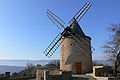 Old windmill
 -
 inside Notre Dame des Lumières church


See also edit

References edit
- ^ "Répertoire national des élus: les maires" (in French). data.gouv.fr, Plateforme ouverte des données publiques françaises. 13 September 2022.
- ^ "Populations légales 2021". The National Institute of Statistics and Economic Studies. 28 December 2023.
External links edit
- Official website
- Notre-Dame de Lumières, a priory in Goult (in French)
Wikimedia Commons has media related to Goult.