Summary
The national park of Gouraya (Arabic: الحديقة الوطنية قورايا) is one of the coastal national parks of Algeria. It is located in Béjaïa Province, near the shrine of Sidi Touati.
| Gouraya National Park | |
|---|---|
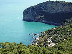 The Aiguades | |
 | |
| Location | Béjaïa Province, Algeria |
| Nearest city | Béjaïa |
| Coordinates | 36°46′N 5°6′E / 36.767°N 5.100°E |
| Area | 20.8 km2 (8.0 sq mi) |
| Established | 1984 |
| Visitors | 60.000 (in 2005) |
|
History
edit
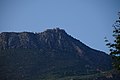
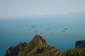
The park became an Algerian National Park in 1984, and has been UNESCO-recognized as a biosphere reserve in 2004.[1] Description editThe park owes its name to the Gouraya Mountain (altitude 660m) located within the park's boundaries.[2] The ground elevation in the park oscillates between -135m and 660m. There is also a lake, the Lake Mézaïa.[1] The park is located on a calcaro-dolomitic ground.[3] The park is north-east of Béjaïa, close to the city. The park includes many beaches and cliffs, which make it a swimming destination for many Algerians. Population editThe permanent population in the Gouraya National Park is of Berber origins, 1,655 inhabitants across 13 villages.[1] Wildlife edit The park is home to a wide variety of flora and fauna, including Barbary macaques and jackals who live in the park's forests. The Barbary macaque is a primate with a very restricted range in portions of northwestern North Africa and disjunctively in Gibraltar.[1] In 2011, the French Institut National de la Recherche Agronomique led a phytosociological study which concluded there were 7 vegetation groups belonging to 4 phytosociological classes:[3]
Gallery edit
Wikimedia Commons has media related to Gouraya National Park. References editExternal links edit
| |