


Summary
Gourdon (French pronunciation: [ɡuʁdɔ̃]; Occitan: Gordon) is a subprefecture of the Lot department in the Occitania region in Southwestern France. In 2019, the commune had a population of 3,981.
Gourdon
Gordon (Occitan) | |
|---|---|
Subprefecture and commune | |
 Gourdon Town Hall | |
 Coat of arms | |
Location of Gourdon .mw-parser-output .locmap .od{position:absolute}.mw-parser-output .locmap .id{position:absolute;line-height:0}.mw-parser-output .locmap .l0{font-size:0;position:absolute}.mw-parser-output .locmap .pv{line-height:110%;position:absolute;text-align:center}.mw-parser-output .locmap .pl{line-height:110%;position:absolute;top:-0.75em;text-align:right}.mw-parser-output .locmap .pr{line-height:110%;position:absolute;top:-0.75em;text-align:left}.mw-parser-output .locmap .pv>div{display:inline;padding:1px}.mw-parser-output .locmap .pl>div{display:inline;padding:1px;float:right}.mw-parser-output .locmap .pr>div{display:inline;padding:1px;float:left}html.skin-theme-clientpref-night .mw-parser-output .od,html.skin-theme-clientpref-night .mw-parser-output .od .pv>div,html.skin-theme-clientpref-night .mw-parser-output .od .pl>div,html.skin-theme-clientpref-night .mw-parser-output .od .pr>div{background:#000;color:#fff}html.skin-theme-clientpref-night .mw-parser-output .locmap{filter:grayscale(0.6)}@media(prefers-color-scheme:dark){html.skin-theme-clientpref-os .mw-parser-output .locmap{filter:grayscale(0.6)}html.skin-theme-clientpref-os .mw-parser-output .od,html.skin-theme-clientpref-os .mw-parser-output .od .pv>div,html.skin-theme-clientpref-os .mw-parser-output .od .pl>div,html.skin-theme-clientpref-os .mw-parser-output .od .pr>div{background:#000;color:#fff}}  Gourdon  Gourdon | |
| Coordinates: 44°44′14″N 1°22′57″E / 44.7371°N 1.3825°E | |
| Country | France |
| Region | Occitania |
| Department | Lot |
| Arrondissement | Gourdon |
| Canton | Gourdon |
| Government | |
| • Mayor (2020–2026) | Jean-Marie Courtin[1] |
| Area 1 | 45.52 km2 (17.58 sq mi) |
| Population (2021)[2] | 3,946 |
| • Density | 87/km2 (220/sq mi) |
| Time zone | UTC+01:00 (CET) |
| • Summer (DST) | UTC+02:00 (CEST) |
| INSEE/Postal code | 46127 /46300 |
| Elevation | 130–323 m (427–1,060 ft) (avg. 263 m or 863 ft) |
| 1 French Land Register data, which excludes lakes, ponds, glaciers > 1 km2 (0.386 sq mi or 247 acres) and river estuaries. | |
The small town, not far from Rocamadour, is situated close to the Dordogne department in the Nouvelle-Aquitaine region. Gourdon has a rich prehistoric past, that can still be seen today through a high concentration of prehistoric sites. It is the capital of the Bouriane, the natural region part of the Quercy, which extends up to the river Dordogne and neighbours the Périgord.
Geography edit
The town lies in the middle of the commune, above the right bank of the Bléou, a stream tributary of the Céou, which forms most of the commune's southern border. Gourdon station has rail connections to Brive-la-Gaillarde, Cahors and Toulouse.
Climate edit
| Climate data for Gourdon, Lot (1981–2010 averages) | |||||||||||||
|---|---|---|---|---|---|---|---|---|---|---|---|---|---|
| Month | Jan | Feb | Mar | Apr | May | Jun | Jul | Aug | Sep | Oct | Nov | Dec | Year |
| Record high °C (°F) | 19.9 (67.8) |
25.2 (77.4) |
27.5 (81.5) |
31.3 (88.3) |
32.9 (91.2) |
40.7 (105.3) |
40.7 (105.3) |
41.8 (107.2) |
36.8 (98.2) |
31.7 (89.1) |
24.5 (76.1) |
19.4 (66.9) |
41.8 (107.2) |
| Mean daily maximum °C (°F) | 8.7 (47.7) |
10.6 (51.1) |
14.2 (57.6) |
16.9 (62.4) |
21.0 (69.8) |
24.6 (76.3) |
27.4 (81.3) |
27.1 (80.8) |
23.5 (74.3) |
18.7 (65.7) |
12.3 (54.1) |
9.2 (48.6) |
17.9 (64.2) |
| Mean daily minimum °C (°F) | 1.6 (34.9) |
1.8 (35.2) |
3.9 (39.0) |
6.0 (42.8) |
9.5 (49.1) |
12.4 (54.3) |
14.3 (57.7) |
14.1 (57.4) |
11.4 (52.5) |
9.2 (48.6) |
4.6 (40.3) |
2.3 (36.1) |
7.6 (45.7) |
| Record low °C (°F) | −19.0 (−2.2) |
−14.2 (6.4) |
−12.8 (9.0) |
−4.5 (23.9) |
−1.4 (29.5) |
1.8 (35.2) |
5.7 (42.3) |
3.8 (38.8) |
0.6 (33.1) |
−4.7 (23.5) |
−9.0 (15.8) |
−13.2 (8.2) |
−19.0 (−2.2) |
| Average precipitation mm (inches) | 62.5 (2.46) |
55.8 (2.20) |
60.9 (2.40) |
85.1 (3.35) |
87.9 (3.46) |
79.0 (3.11) |
60.0 (2.36) |
63.6 (2.50) |
77.6 (3.06) |
78.3 (3.08) |
74.6 (2.94) |
71.4 (2.81) |
856.7 (33.73) |
| Average precipitation days | 10.6 | 9.3 | 10.0 | 11.5 | 11.9 | 8.7 | 7.1 | 8.0 | 8.6 | 10.4 | 10.9 | 10.9 | 117.9 |
| Average snowy days | 2.3 | 2.2 | 1.6 | 0.8 | 0.0 | 0.0 | 0.0 | 0.0 | 0.0 | 0.1 | 1.0 | 1.9 | 9.9 |
| Average relative humidity (%) | 84 | 78 | 74 | 70 | 73 | 73 | 70 | 73 | 76 | 81 | 84 | 85 | 76.8 |
| Mean monthly sunshine hours | 100.5 | 120.7 | 173.9 | 178.6 | 213.7 | 244.6 | 262.1 | 247.4 | 207.8 | 146.3 | 93.2 | 90.3 | 2,078.9 |
| Source 1: Météo France[3][4] | |||||||||||||
| Source 2: Infoclimat.fr (humidity and snowy days, 1961–1990)[5] | |||||||||||||
Demographics edit
| Year | Pop. | ±% p.a. |
|---|---|---|
| 1968 | 4,803 | — |
| 1975 | 4,728 | −0.22% |
| 1982 | 4,899 | +0.51% |
| 1990 | 4,851 | −0.12% |
| 1999 | 4,882 | +0.07% |
| 2007 | 4,636 | −0.64% |
| 2012 | 4,406 | −1.01% |
| 2017 | 4,094 | −1.46% |
| Source: INSEE[6] | ||
Monuments edit
-
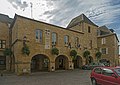 Town Hall
 -
 St. Peter Church facade
 -
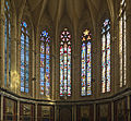 St. Peter Church interior


See also edit
References edit
- ^ "Répertoire national des élus: les maires" (in French). data.gouv.fr, Plateforme ouverte des données publiques françaises. 13 September 2022.
- ^ "Populations légales 2021". The National Institute of Statistics and Economic Studies. 28 December 2023.
- ^ "Données climatiques de la station de Gourdon" (in French). Meteo France. Retrieved 8 January 2016.
- ^ "Climat Midi-Pyrénées" (in French). Meteo France. Archived from the original on 3 August 2019. Retrieved 8 January 2016.
- ^ "Normes et records 1961-1990: Gourdon (46) - altitude 259m" (in French). Infoclimat. Archived from the original on 4 March 2016. Retrieved 8 January 2016.
- ^ Population en historique depuis 1968, INSEE