


Summary
North Somerset is a unitary authority in the ceremonial county of Somerset, England. As a unitary authority, North Somerset is administered independently of the non-metropolitan county of Somerset. Its administrative headquarters are located in the town hall of Weston-super-Mare.[1]

In the United Kingdom, the term listed building refers to a building or other structure officially designated as being of special architectural, historical or cultural significance; Grade II* structures are those considered to be "particularly significant buildings of more than local interest".[2] Listing was begun by a provision in the Town and Country Planning Act 1947. Once listed, severe restrictions are imposed on the modifications allowed to a building's structure or its fittings. In England, the authority for listing under the Planning (Listed Buildings and Conservation Areas) Act 1990[3] rests with Historic England, a non-departmental public body sponsored by the Department for Digital, Culture, Media and Sport; local authorities have a responsibility to regulate and enforce the planning regulations.[4]
There are 80 Grade II* listed buildings in North Somerset. The oldest are Norman churches. From the Middle Ages onward there are more churches and some manor houses, such as Tyntesfield, Clevedon Court and Leigh Court, with their ancillary buildings. The list includes several village or church crosses and monuments in churchyards. More recent entries include Birnbeck Pier which was designed by Eugenius Birch and opened in 1867,[5] and the Waterworks at Blagdon which was completed in 1905.[6]
Buildings edit
| Name | Location | Type | Completed [note 1] | Grid ref.[note 2] Geo-coordinates |
Entry number [note 3] | Image | Ref. |
|---|---|---|---|---|---|---|---|
| Alburys | Wrington | Villa | 1846 | ST4685163075 51°21′51″N 2°45′53″W / 51.36424°N 2.764799°W |
1320922 |  Upload Photo |
[7] |
| Banwell Abbey The Cloisters | Banwell | Bishops Palace | 14th century | ST4002259136 51°19′41″N 2°51′44″W / 51.328144°N 2.862212°W |
1135732 | Upload Photo |
[8] |
| Banwell Castle, terraces and courtyard walls | Banwell | House | c. 1848 | ST4057158608 51°19′24″N 2°51′15″W / 51.323455°N 2.854245°W |
1283203 |  More images |
[9] |
| Barn to south west of Powdermill Farmhouse | Winford | Powder Magazine | 18th century | ST5504864299 51°22′33″N 2°38′50″W / 51.375955°N 2.647224°W |
1158144 |  |
[10] |
| Barn, 50 yards south east of Chelvey Court | Brockley | Barn | 15th century | ST4660868323 51°24′41″N 2°46′09″W / 51.411401°N 2.76908°W |
1129823 | Upload Photo |
[11] |
| Barrow Court | Barrow Gurney | Country House | c. 1538 | ST5143068437 51°24′46″N 2°41′59″W / 51.412861°N 2.699769°W |
1311901 |  More images |
[12] |
| Birdcombe Court and Birdcombe Court Farmhouse | Wraxall And Failand | Farmhouse | 14th century | ST4793071894 51°26′37″N 2°45′02″W / 51.44363°N 2.750599°W |
1311776 |  More images |
[13] |
| Birnbeck Pier | Weston-super-Mare | Pier | 1867 | ST3070362481 51°21′26″N 2°59′48″W / 51.357156°N 2.996593°W |
1129718 | 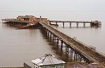 More images |
[14] |
| Butcombe Farmhouse | Butcombe | Farmhouse | 15th century | ST5036260816 51°20′39″N 2°42′51″W / 51.344248°N 2.714057°W |
1129229 | 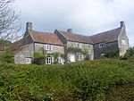 |
[15] |
| Chapel, immediately south of ower Court Farmhouse | Long Ashton | Chantry Chapel | Late 14th–early 15th century | ST5489270239 51°25′46″N 2°39′01″W / 51.429349°N 2.650223°W |
1129041 | Upload Photo |
[16] |
| Chelvey Court and bridge to the east and 2 outbuildings to the south west | Brockley | Manor House | 1618–1660 | ST4654968382 51°24′43″N 2°46′12″W / 51.411926°N 2.769937°W |
1312236 | Upload Photo |
[17] |
| Christ Church | Clevedon | Church | 1839 | ST4088771459 51°26′20″N 2°51′07″W / 51.439027°N 2.851853°W |
1129663 |  More images |
[18] |
| Church of All Saints | Long Ashton | Anglican Church | 14th century | ST5534270956 51°26′09″N 2°38′38″W / 51.435831°N 2.643841°W |
1138021 |  More images |
[19] |
| Church of All Saints | Weston-super-Mare | Church | 1902 | ST3204762027 51°21′12″N 2°58′38″W / 51.353237°N 2.977208°W |
1129717 |  More images |
[20] |
| Church of Holy Trinity | Cleeve | Parish Church | 1840 | ST4600766065 51°23′28″N 2°46′39″W / 51.391043°N 2.777376°W |
1129095 |  More images |
[21] |
| Church of Saint Martin | Worle | Church | Norman | ST3530562895 51°21′41″N 2°55′50″W / 51.361422°N 2.930587°W |
1137549 | 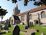 More images |
[22] |
| Church of Saint Mary The Virgin | Hutton | Anglican Church | 15th century | ST3524458595 51°19′22″N 2°55′50″W / 51.322755°N 2.930679°W |
1320975 |  More images |
[23] |
| Church of St Andrew | Blagdon | Parish Church | 15th century | ST5041258973 51°19′40″N 2°42′47″W / 51.327682°N 2.713082°W |
1146388 | 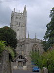 More images |
[24] |
| Church of St George | Easton-In-Gordano | Anglican Church | 14th and 15th century | ST5142575746 51°28′43″N 2°42′03″W / 51.478574°N 2.700846°W |
1129826 | 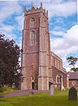 More images |
[25] |
| Church of St John | Clevedon | Church | 1875–1878 | ST4066471209 51°26′12″N 2°51′18″W / 51.436756°N 2.855019°W |
1312770 |  More images |
[26] |
| Church of St John The Evangelist | Kenn | Parish Church | Norman | ST4159368975 51°25′00″N 2°50′29″W / 51.416768°N 2.841287°W |
1136680 | 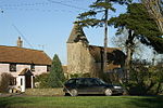 More images |
[27] |
| Church of St Mary and St Edward | Barrow Gurney | Parish Church | 12th century | ST5146568449 51°24′47″N 2°41′57″W / 51.412971°N 2.699267°W |
1311925 |  More images |
[28] |
| Church of St Mary and St Peter | Winford | Parish Church | 15th century | ST5430665014 51°22′56″N 2°39′29″W / 51.382324°N 2.657976°W |
1320916 |  More images |
[29] |
| Church of St Michael and All Angels | Butcombe | Parish Church | 15th century | ST5153861873 51°21′14″N 2°41′50″W / 51.353853°N 2.697318°W |
1129189 |  More images |
[30] |
| Church of St Michael and All Angels | Flax Bourton | Anglican Church | 12th century | ST5065569376 51°25′16″N 2°42′40″W / 51.421236°N 2.711042°W |
1129835 | 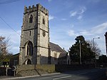 More images |
[31] |
| Church of St Nicholas | Brockley | Anglican Church | 12th century | ST4658666979 51°23′58″N 2°46′09″W / 51.399315°N 2.769193°W |
1137608 |  More images |
[32] |
| Churchyard cross | Butcombe | Cross | 15th century | ST5154061855 51°21′13″N 2°41′50″W / 51.353691°N 2.697287°W |
1129190 |  |
[33] |
| Churchyard Cross, in the churchyard and to the south of All Saints' Church | Wraxall | Cross | 15th century | ST4902371945 51°26′39″N 2°44′06″W / 51.444189°N 2.734882°W |
1320988 | Upload Photo |
[34] |
| Coachhouse at Banwell Castle | Banwell | Granary | c. 1848 | ST4011658669 51°19′26″N 2°51′39″W / 51.323956°N 2.860784°W |
1129781 | Upload Photo |
[35] |
| Court Farmhouse | Winford | Farmhouse | 1593 | ST5428664957 51°22′55″N 2°39′30″W / 51.38181°N 2.658256°W |
1129214 |  |
[36] |
| Court House Farmhouse | Portishead | Farmhouse | Late Medieval | ST4666375972 51°28′49″N 2°46′10″W / 51.480176°N 2.769444°W |
1220237 | Upload Photo |
[37] |
| Crenellated wall and circular tower running from north-east corner of Clevedon Court | Clevedon | Kitchen | 13th century | ST4227271612 51°26′26″N 2°49′55″W / 51.440546°N 2.831955°W |
1129699 |  |
[38] |
| East and west corner gazebos and linking north boundary wall of formal garden at Barrow Court | Barrow Gurney | Balustrade | c. 1890 | ST5155068499 51°24′48″N 2°41′53″W / 51.413428°N 2.698052°W |
1129169 |  |
[39] |
| East and west courts and linking south boundary wall of formal garden at Barrow Court | Barrow Gurney | Boundary Wall | c. 1890 | ST5139268524 51°24′49″N 2°42′01″W / 51.41364°N 2.700327°W |
1320932 | Upload Photo |
[40] |
| Farmhouse range adjoining Priory | Kewstoke | Farmhouse | 16th century | ST3433966170 51°23′27″N 2°56′42″W / 51.390754°N 2.945066°W |
1129766 |  |
[41] |
| Friends Meeting House | Yatton | House | 17th century | ST4525866288 51°23′35″N 2°47′17″W / 51.392976°N 2.788174°W |
1320963 | Upload Photo |
[42] |
| Gatcombe Court | Long Ashton | Manor House | Late 14th–15th century | ST5254769859 51°25′33″N 2°41′02″W / 51.425741°N 2.6839°W |
1137925 |  More images |
[43] |
| Gatehouse, stables and flanking walls at Banwell Castle | Banwell | Gate | c. 1848 | ST4014458650 51°19′26″N 2°51′37″W / 51.323788°N 2.860379°W |
1320658 | Upload Photo |
[44] |
| Gatepiers, gates and series of 12 pillars forming west boundary wall of garden at Barrow Court | Flax Bourton | Gate | c. 1890 | ST5138668560 51°24′50″N 2°42′02″W / 51.413963°N 2.700418°W |
1129171 | 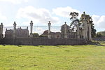 |
[45] |
| Holy Trinity Church | Abbots Leigh | Anglican Church | 15th century | ST5444274018 51°27′48″N 2°39′26″W / 51.46329°N 2.657183°W |
1312353 |  More images |
[46] |
| Holy Trinity Church | Weston-super-Mare | Church | 1861 | ST3124062312 51°21′21″N 2°59′20″W / 51.355702°N 2.98885°W |
1137827 |  More images |
[47] |
| Home Farm Buildings, Tyntesfield | Wraxall | Dairy | 1881 | ST5016471711 51°26′32″N 2°43′06″W / 51.442187°N 2.718432°W |
1061341 |  More images |
[48] |
| Hutton Court | Hutton | Manor House | Late 15th–20th century | ST3529358588 51°19′22″N 2°55′48″W / 51.322698°N 2.929975°W |
1320991 | 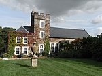 More images |
[49] |
| Lake Farmhouse | Kenn | Farmhouse | c. 1600 | ST4056569354 51°25′12″N 2°51′22″W / 51.420068°N 2.856132°W |
1136606 | Upload Photo |
[50] |
| Leigh Court | Abbots Leigh | Country House | 1814 | ST5431674724 51°28′11″N 2°39′33″W / 51.469627°N 2.659088°W |
1000407 |  More images |
[51] |
| Lily pond and 2 ornamental pedestals with urns each 20 metres either side of pond in rose garden at Barrow Court | Barrow Gurney | Column | c. 1890 | ST5142468493 51°24′48″N 2°42′00″W / 51.413364°N 2.699863°W |
1129172 | Upload Photo |
[52] |
| Medieval Cross 5 yards from south porch in St Peter's churchyard | Portishead | Cross | Late medieval | ST4662476000 51°28′50″N 2°46′12″W / 51.480424°N 2.77001°W |
1291083 | Upload Photo |
[53] |
| Monument to Anna Whiting, in the churchyard and to south of All Saints' Church | Long Ashton | Chest Tomb | 1700 | ST5535870946 51°26′09″N 2°38′37″W / 51.435743°N 2.64361°W |
1129848 | Upload Photo |
[54] |
| Monument to Elizabeth Phelps, in the churchyard to south of All Saints' Church | Long Ashton | Chest Tomb | 1698 or 1699 | ST5535870939 51°26′08″N 2°38′37″W / 51.43568°N 2.643609°W |
1311995 | Upload Photo |
[55] |
| Monument to George Whiting, in the churchyard to south of All Saints' Church | Long Ashton | Chest Tomb | 1709 | ST5535770945 51°26′09″N 2°38′37″W / 51.435734°N 2.643624°W |
1320651 | Upload Photo |
[56] |
| Monument to John and Alice Smith, in the churchyard to west of All Saints' Church | Long Ashton | Chest Tomb | 1591 | ST5532470959 51°26′09″N 2°38′39″W / 51.435857°N 2.6441°W |
1129026 | Upload Photo |
[57] |
| Monument to Robert Whiting, 1662, in the churchyard to south of All Saints' Church | Long Ashton | Chest Tomb | 1662 | ST5535770949 51°26′09″N 2°38′37″W / 51.43577°N 2.643624°W |
1129847 | Upload Photo |
[58] |
| Monument to Robert Whiting, 1679, in the churchyard to south of All Saints' Church | Long Ashton | Chest Tomb | 1679 | ST5535770948 51°26′09″N 2°38′37″W / 51.435761°N 2.643624°W |
1138107 | Upload Photo |
[59] |
| Monument to Robert Whiting, 1693, in the churchyard to south of All Saints' Church | Long Ashton | Chest Tomb | 1693 | ST5535970945 51°26′09″N 2°38′37″W / 51.435734°N 2.643595°W |
1138115 | Upload Photo |
[60] |
| Newtons | Kewstoke | Farmhouse | 17th century | ST3515463614 51°22′04″N 2°55′58″W / 51.367869°N 2.932887°W |
1320690 |  More images |
[61] |
| No 2 Former Hannah More Infants School | Nailsea | Barn | Late 15th or early 16th century | ST4657569901 51°25′32″N 2°46′11″W / 51.425585°N 2.769793°W |
1129115 | Upload Photo |
[62] |
| Old Church of St Nicholas | Uphill | Church | Norman | ST3161558373 51°19′13″N 2°58′58″W / 51.320334°N 2.982707°W |
1129743 |  More images |
[63] |
| Orangery, Tyntesfield | Wraxall | Orangery | 1897 | ST5066271155 51°26′14″N 2°42′40″W / 51.437231°N 2.71119°W |
1061355 |  More images |
[64] |
| Parish Church of St Andrew | Loxton | Parish Church | 11th century | ST3762455824 51°17′53″N 2°53′46″W / 51.298109°N 2.896044°W |
1313078 |  More images |
[65] |
| Parish Church of St Augustine | Locking | Parish Church | Late 14th or early 15th century | ST3635459637 51°19′56″N 2°54′54″W / 51.332249°N 2.914939°W |
1135810 |  More images |
[66] |
| Parish Church of St Lawrence | Wick St. Lawrence | Church | 15th century | ST3663665440 51°23′04″N 2°54′43″W / 51.384453°N 2.911927°W |
1129773 |  More images |
[67] |
| Powdermill Farmhouse | Winford | House | Later 17th century | ST5507764301 51°22′34″N 2°38′49″W / 51.375975°N 2.646808°W |
1158132 |  |
[68] |
| Sores Court | Backwell | Farmhouse | Mid-late 17th century | ST4860367758 51°24′23″N 2°44′25″W / 51.406506°N 2.740315°W |
1312284 |  More images |
[69] |
| St Brandon's School for Girls | Clevedon | House | 1850 | ST4005171122 51°26′09″N 2°51′50″W / 51.435909°N 2.863822°W |
1129704 |  More images |
[70] |
| Steps, walls, ornamental vases and sundial forming junction between rose garden and north lawn at Barrow Court | Barrow Gurney | Wall | c. 1890 | ST5143268508 51°24′49″N 2°41′59″W / 51.413499°N 2.69975°W |
1129173 | Upload Photo |
[71] |
| Temple, exedra and linking east boundary wall of formal garden at Barrow Court | Barrow Gurney | Balustrade | c. 1890 | ST5154368455 51°24′47″N 2°41′53″W / 51.413032°N 2.698146°W |
1129170 | Upload Photo |
[72] |
| Terrace and dairy at Banwell Castle | Banwell | Dairy | c. 1848 | ST4018558647 51°19′26″N 2°51′35″W / 51.323765°N 2.85979°W |
1135437 | Upload Photo |
[73] |
| The Bell House | Weston-super-Mare | House | Late medieval | ST3553462982 51°21′44″N 2°55′38″W / 51.36223°N 2.927314°W |
1129726 |  |
[74] |
| The Court | Tickenham | Farmhouse | c. 1400 | ST4575271493 51°26′23″N 2°46′55″W / 51.43982°N 2.781873°W |
1312529 | 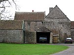 More images |
[75] |
| The Grange | Portishead | House | 19th century | ST4666875571 51°28′36″N 2°46′10″W / 51.476572°N 2.769312°W |
1220300 | Upload Photo |
[76] |
| The Parsonage | Winford | House | c. 1700 | ST5297664293 51°22′33″N 2°40′37″W / 51.375733°N 2.67699°W |
1129217 | 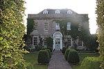 More images |
[77] |
| Tithe Barn at Barrow Court | Barrow Gurney | House | 14th century | ST5139768452 51°24′47″N 2°42′01″W / 51.412993°N 2.700245°W |
1129208 |  More images |
[78] |
| Unidentified Chest Tomb, 18 metres east of east end of All Saints Church | Kingston Seymour | Chest Tomb | 15th or 16th century | ST4011266859 51°23′51″N 2°51′44″W / 51.397589°N 2.862223°W |
1135989 | Upload Photo |
[79] |
| Uphill Manor | Weston-super-Mare | House | c. 1805 | ST3190959009 51°19′34″N 2°58′43″W / 51.326087°N 2.978611°W |
1137993 |  |
[80] |
| Urchinwood Manor | Congresbury | Manor House | 1620 | ST4473563556 51°22′06″N 2°47′43″W / 51.368362°N 2.795264°W |
1129209 | Upload Photo |
[81] |
| Village Cross | Congresbury | Steps | 15th century | ST4373363816 51°22′14″N 2°48′35″W / 51.370601°N 2.809698°W |
1158002 |  |
[82] |
| Village Cross 5 yards east of Banksea Cottages | Wick St. Lawrence | Village Cross | 15th century | ST3660565388 51°23′02″N 2°54′45″W / 51.383982°N 2.912363°W |
1129775 |  |
[83] |
| Waterworks at Blagdon: Pumping Station with Receiving Tanks | Blagdon | Pumping station | 1905 | ST5035160018 51°20′13″N 2°42′51″W / 51.3370°N 2.7141°W |
1320936 |  More images |
[84] |
| West garden walls with towers at Banwell Castle | Banwell | Tower | c. 1848 | ST4010258658 51°19′26″N 2°51′40″W / 51.323855°N 2.860983°W |
1129782 | Upload Photo |
[85] |
| Woodspring District Council Offices (Housing Services Department) | Clevedon | House | Mid 19th century | ST4098571484 51°26′21″N 2°51′02″W / 51.439262°N 2.850448°W |
1312828 | Upload Photo |
[86] |
See also edit
Notes edit
- ^ The date given is the date used by Historic England as significant for the initial building or that of an important part in the structure's description.
- ^ Sometimes known as OSGB36, the grid reference is based on the British national grid reference system used by the Ordnance Survey.
- ^ The "List Entry Number" is a unique number assigned to each listed building and scheduled monument by Historic England.
References edit
- ^ "Town Hall". North Somerset Council. Archived from the original on 30 October 2016. Retrieved 3 May 2017.
- ^ "Listed Buildings". Historic England. Retrieved 23 August 2017.
- ^ "Planning (Listed Buildings and Conservation Areas) Act 1990 (c. 9)". Ministry of Justice. Archived from the original on 18 April 2010. Retrieved 17 December 2007.
- ^ "Historic England's Role". Historic England. Archived from the original on 10 August 2016. Retrieved 3 May 2017.
- ^ Terrell, Stan (2001) [First published 1966]. Birnbeck Pier Weston-super-Mare, a short history. Weston-super-Mare: North Somerset Museum Service. pp. 5–8. ISBN 978-0-901104-10-6.
- ^ "Waterworks at Blagdon: Pumping Station with Receiving Tanks". National Heritage List for England. Historic England. Archived from the original on 31 October 2015. Retrieved 3 May 2017.
- ^ Historic England. "Alburys (1320922)". National Heritage List for England. Retrieved 3 April 2015.
- ^ Historic England. "Banwell Abbey the cloisters (1135732)". National Heritage List for England. Retrieved 3 April 2015.
- ^ Historic England. "Banwell Castle, Terraces And Courtyard Walls (1283203)". National Heritage List for England. Retrieved 3 April 2015.
- ^ Historic England. "Barn To South West Of Powdermill Farmhouse (1158144)". National Heritage List for England. Retrieved 3 April 2015.
- ^ Historic England. "Barn, 50 Yards South East Of Chelvey Court (1129823)". National Heritage List for England. Retrieved 3 April 2015.
- ^ Historic England. "Barrow Court (1311901)". National Heritage List for England. Retrieved 3 April 2015.
- ^ Historic England. "Birdcombe Court And Birdcombe Court Farmhouse (1311776)". National Heritage List for England. Retrieved 3 April 2015.
- ^ Historic England. "Birnbeck Pier (1129718)". National Heritage List for England. Retrieved 3 April 2015.
- ^ Historic England. "Butcombe Farmhouse (1129229)". National Heritage List for England. Retrieved 3 April 2015.
- ^ Historic England. "Chapel, Immediately South Of Lower Court Farmhouse (1129041)". National Heritage List for England. Retrieved 3 April 2015.
- ^ Historic England. "Chelvey Court And Bridge To The East And 2 Outbuildings To The South West (1312236)". National Heritage List for England. Retrieved 3 April 2015.
- ^ Historic England. "Christ Church (1129663)". National Heritage List for England. Retrieved 3 April 2015.
- ^ Historic England. "Church Of All Saints (1138021)". National Heritage List for England. Retrieved 3 April 2015.
- ^ Historic England. "Church Of All Saints (1129717)". National Heritage List for England. Retrieved 3 April 2015.
- ^ Historic England. "Church Of Holy Trinity (1129095)". National Heritage List for England. Retrieved 3 April 2015.
- ^ Historic England. "Church Of Saint Martin (1137549)". National Heritage List for England. Retrieved 3 April 2015.
- ^ Historic England. "Church Of Saint Mary The Virgin (1320975)". National Heritage List for England. Retrieved 3 April 2015.
- ^ Historic England. "Church Of St Andrew (1146388)". National Heritage List for England. Retrieved 3 April 2015.
- ^ Historic England. "Church Of St George (1129826)". National Heritage List for England. Retrieved 3 April 2015.
- ^ Historic England. "Church Of St John (1312770)". National Heritage List for England. Retrieved 3 April 2015.
- ^ Historic England. "Church Of St John The Evangelist (1136680)". National Heritage List for England. Retrieved 3 April 2015.
- ^ Historic England. "Church Of St Mary And St Edward (1311925)". National Heritage List for England. Retrieved 3 April 2015.
- ^ Historic England. "Church Of St Mary And St Peter (1320916)". National Heritage List for England. Retrieved 3 April 2015.
- ^ Historic England. "Church Of St Michael And All Angels (1129189)". National Heritage List for England. Retrieved 3 April 2015.
- ^ Historic England. "Church Of St Michael And All Angels (1129835)". National Heritage List for England. Retrieved 3 April 2015.
- ^ Historic England. "Church Of St Nicholas (1137608)". National Heritage List for England. Retrieved 3 April 2015.
- ^ Historic England. "Churchyard cross (1129190)". National Heritage List for England. Retrieved 3 April 2015.
- ^ Historic England. "Churchyard Cross, In The Churchyard And To The South Of All Saint's Church (1320988)". National Heritage List for England. Retrieved 7 July 2015.
- ^ Historic England. "Coachhouse at Banwell Castle (1129781)". National Heritage List for England. Retrieved 3 April 2015.
- ^ Historic England. "Court Farmhouse (1129214)". National Heritage List for England. Retrieved 3 April 2015.
- ^ Historic England. "Court House Farmhouse (1220237)". National Heritage List for England. Retrieved 3 April 2015.
- ^ Historic England. "Crenallated Wall And Circular Tower Running From North-East Corner Of Clevedon Court (1129699)". National Heritage List for England. Retrieved 3 April 2015.
- ^ Historic England. "East And West Corner Gazebos And Linking North Boundary Wall Of Formal Garden At Barrow Court (1129169)". National Heritage List for England. Retrieved 3 April 2015.
- ^ Historic England. "East And West Courts And Linking South Boundary Wall Of Formal Garden At Barrow Court (1320932)". National Heritage List for England. Retrieved 3 April 2015.
- ^ Historic England. "Farmhouse Range adjoining Priory (1129766)". National Heritage List for England. Retrieved 3 April 2015.
- ^ Historic England. "Friends Meeting House (1320963)". National Heritage List for England. Retrieved 3 April 2015.
- ^ Historic England. "Gatcombe Court (1137925)". National Heritage List for England. Retrieved 3 April 2015.
- ^ Historic England. "Gatehouse, Stables And Flanking Walls At Banwell Castle (1320658)". National Heritage List for England. Retrieved 3 April 2015.
- ^ Historic England. "Gatepiers, Gates And Series Of 12 Pillars Forming West Boundary Wall Of Garden At Barrow Court (1129171)". National Heritage List for England. Retrieved 3 April 2015.
- ^ Historic England. "Holy Trinity Church (1312353)". National Heritage List for England. Retrieved 3 April 2015.
- ^ Historic England. "Holy Trinity Church (1137827)". National Heritage List for England. Retrieved 3 April 2015.
- ^ Historic England. "Home Farm Buildings, Tyntesfield (1061341)". National Heritage List for England. Retrieved 3 April 2015.
- ^ Historic England. "Hutton Court (1320991)". National Heritage List for England. Retrieved 3 April 2015.
- ^ Historic England. "Lake Farmhouse (1136606)". National Heritage List for England. Retrieved 3 April 2015.
- ^ Historic England. "Leigh Court (1000407)". National Heritage List for England. Retrieved 15 January 2017.
- ^ Historic England. "Lily Pond And 2 Ornamental Pedestals With Urns Each 20 Metres Either Side Of Pond In Rose Garden At Barrow Court (1129172)". National Heritage List for England. Retrieved 3 April 2015.
- ^ Historic England. "Medieval Cross 5 Yards From South Porch In St Peter's Churchyard (1291083)". National Heritage List for England. Retrieved 7 July 2015.
- ^ Historic England. "Monument to Anna Whiting, in the Churchyard and to south of All Saints' Church (1129848)". National Heritage List for England. Retrieved 7 July 2015.
- ^ Historic England. "Monument to Elizabeth Phelps, in the Churchyard to South of All Saints' Church (1311995)". National Heritage List for England. Retrieved 7 July 2015.
- ^ Historic England. "Monument to George Whiting, in the Churchyard uo South of All Saints' Church (1320651)". National Heritage List for England. Retrieved 7 July 2015.
- ^ Historic England. "Monument To John And Alice Smith, In The Churchyard To West Of All Saints' Church (1129026)". National Heritage List for England. Retrieved 7 July 2015.
- ^ Historic England. "Monument to Robert Whiting, 1662, in the Churchyard uo South of All Saints' Church (1129847)". National Heritage List for England. Retrieved 7 July 2015.
- ^ Historic England. "Monument to Robert Whiting, 1679, in the Churchyard to south of All Saints' Church (1138107)". National Heritage List for England. Retrieved 7 July 2015.
- ^ Historic England. "Monument To Robert Whiting, 1693, In The Churchyard To South Of All Saints' Church (1138115)". National Heritage List for England. Retrieved 7 July 2015.
- ^ Historic England. "Newtons (1320690)". National Heritage List for England. Retrieved 3 April 2015.
- ^ Historic England. "No 2 Former Hannah More Infants School (1129115)". National Heritage List for England. Retrieved 3 April 2015.
- ^ Historic England. "Old Church of St Nicholas (1129743)". National Heritage List for England. Retrieved 3 April 2015.
- ^ Historic England. "Orangery, Tyntesfield (1061355)". National Heritage List for England. Retrieved 3 April 2015.
- ^ Historic England. "Parish Church Of St Andrew (1313078)". National Heritage List for England. Retrieved 3 April 2015.
- ^ Historic England. "Parish Church Of St Augustine (1135810)". National Heritage List for England. Retrieved 3 April 2015.
- ^ Historic England. "Parish Church of St Lawrence (1129773)". National Heritage List for England. Retrieved 3 April 2015.
- ^ Historic England. "Powdermill Farmhouse (1158132)". National Heritage List for England. Retrieved 3 April 2015.
- ^ Historic England. "Sores Court (1312284)". National Heritage List for England. Retrieved 3 April 2015.
- ^ Historic England. "St Brandon's School For Girls (1129704)". National Heritage List for England. Retrieved 7 July 2015.
- ^ Historic England. "Steps, Walls, Ornamental Vases and Sundial Forming Junction Between Rose Garden and North Lawn at Barrow Court (1129173)". National Heritage List for England. Retrieved 3 April 2015.
- ^ Historic England. "Temple, Exedra And Linking East Boundary Wall Of Formal Garden At Barrow Court (1129170)". National Heritage List for England. Retrieved 3 April 2015.
- ^ Historic England. "Terrace And Dairy At Banwell Castle (1135437)". National Heritage List for England. Retrieved 3 April 2015.
- ^ Historic England. "The Bell House (1129726)". National Heritage List for England. Retrieved 3 April 2015.
- ^ Historic England. "The Court (1312529)". National Heritage List for England. Retrieved 3 April 2015.
- ^ Historic England. "The Grange (1220300)". National Heritage List for England. Retrieved 3 April 2015.
- ^ Historic England. "The Parsonage (1129217)". National Heritage List for England. Retrieved 3 April 2015.
- ^ Historic England. "Tithe Barn At Barrow Court (1129208)". National Heritage List for England. Retrieved 3 April 2015.
- ^ Historic England. "Unidentified Chest Tomb, 18 Metres East Of East End Of All Saints Church (1135989)". National Heritage List for England. Retrieved 3 April 2015.
- ^ Historic England. "Uphill Manor (1137993)". National Heritage List for England. Retrieved 3 April 2015.
- ^ Historic England. "Urchinwood Manor (1129209)". National Heritage List for England. Retrieved 3 April 2015.
- ^ Historic England. "Village Cross (1158002)". National Heritage List for England. Retrieved 3 April 2015.
- ^ Historic England. "Village Cross 5 Yards East Of Banksea Cottages (1129775)". National Heritage List for England. Retrieved 3 April 2015.
- ^ Historic England. "Waterworks at Blagdon: Pumping Station with Receiving Tanks (1320936)". National Heritage List for England. Retrieved 3 May 2017.
- ^ Historic England. "West Garden Walls With Towers At Banwell Castle (1129782)". National Heritage List for England. Retrieved 3 April 2015.
- ^ Historic England. "Woodspring District Council Offices (Housing Services Department) (1312828)". National Heritage List for England. Retrieved 3 April 2015.
External links edit