
KNOWPIA
WELCOME TO KNOWPIA

Grade II* listed buildings on the Isle of Wight 
Summary
There are over 20,000 Grade II* listed buildings in England. This page is a list of these buildings in the county of the Isle of Wight.
Isle of Wight edit
| Name | Location | Type | Completed [note 1] | Date designated | Grid ref.[note 2] Geo-coordinates |
Entry number [note 3] | Image |
|---|---|---|---|---|---|---|---|
| Arreton Manor | Arreton, Isle of Wight | Manor House | Between 1595 and 1612 | 21 July 1951 | SZ5333786866 50°40′44″N 1°14′47″W / 50.679017°N 1.246462°W |
1292259 |  More images
|
| Haseley Manor | Arreton, Isle of Wight | Dairy | 18th century | 21 July 1951 | SZ5471285719 50°40′07″N 1°13′38″W / 50.668576°N 1.227172°W |
1292781 |  More images
|
| Merstone Manor | Merstone, Arreton, Isle of Wight | Manor House | 1605 | 21 July 1951 | SZ5214485437 50°39′59″N 1°15′49″W / 50.666276°N 1.263547°W |
1292159 |  Upload Photo |
| Standen House | Arreton, Isle of Wight | House | 18th century addition | 2 August 1957 | SZ5071287113 50°40′53″N 1°17′01″W / 50.681473°N 1.283578°W |
1209182 | 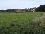 More images
|
| Nunwell House | Brading, Isle of Wight | Coal Shed | 19th century | 21 July 1951 | SZ5955687409 50°41′00″N 1°09′30″W / 50.683298°N 1.158364°W |
1219725 | 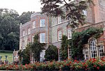 More images
|
| Mottistone Manor, the Dower House | Mottistone, Brighstone, Isle of Wight | Farmhouse | 15th century or early 16th century | 21 July 1951 | SZ4062983797 50°39′09″N 1°25′36″W / 50.652443°N 1.426649°W |
1209289 |  More images
|
| Church of All Saints | Calbourne, Isle of Wight | Parish Church | 13th century | 18 January 1957 | SZ4249986563 50°40′38″N 1°24′00″W / 50.677183°N 1.399881°W |
1218604 |  More images
|
| Newtown Old Town Hall | Calbourne, Isle of Wight | Museum | c. 1699 | 18 January 1967 | SZ4237090564 50°42′47″N 1°24′04″W / 50.71317°N 1.401249°W |
1209336 |  More images
|
| Shalcombe Manor | Shalcombe, Calbourne, Isle of Wight | House | 1994 | 28 March 1994 | SZ3954185631 50°40′08″N 1°26′31″W / 50.66901°N 1.441843°W |
1292704 | Upload Photo |
| Swainston Manor | Calbourne, Isle of Wight | House | 16th century | 21 July 1951 | SZ4410887818 50°41′18″N 1°22′37″W / 50.688349°N 1.376962°W |
1209329 | 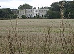 More images
|
| Westover | Calbourne, Isle of Wight | House | c. 1760 | 18 January 1967 | SZ4235386331 50°40′30″N 1°24′07″W / 50.675107°N 1.401974°W |
1292706 | 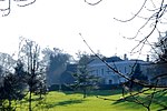 More images
|
| Barn at Chale Abbey | Chale, Isle of Wight | Barn | Early 16th century | 21 July 1951 | SZ4853677818 50°35′53″N 1°18′56″W / 50.598076°N 1.315589°W |
1292753 | Upload Photo |
| Chale Abbey | Chale, Isle of Wight | House | 1951 | 21 July 1951 | SZ4860177820 50°35′53″N 1°18′53″W / 50.598088°N 1.314671°W |
1218207 | Upload Photo |
| Church of St Andrew | Chale, Isle of Wight | Parish Church | 14th century | 18 January 1967 | SZ4832377567 50°35′45″N 1°19′07″W / 50.595836°N 1.318631°W |
1209203 |  More images
|
| Church of St Mary | Cowes, Isle of Wight | Tower | 1815-1816 | 17 August 1951 | SZ4933196170 50°45′47″N 1°18′07″W / 50.763032°N 1.301915°W |
1222748 |  More images
|
| Hammerhead Crane at J S White Shipyard | Cowes, Isle of Wight | Cantilever Crane | 1911 | 2 August 2004 | SZ4997895469 50°45′24″N 1°17′34″W / 50.756673°N 1.292837°W |
1390949 |  More images
|
| Ivy House | Cowes, Isle of Wight | House | 18th century | 17 August 1951 | SZ4953296163 50°45′47″N 1°17′57″W / 50.762952°N 1.299066°W |
1267244 | Upload Photo |
| Northwood House (former offices of Medina Borough Council) | Cowes, Isle of Wight | House | Early 19th century | 17 August 1951 | SZ4924496207 50°45′48″N 1°18′11″W / 50.763372°N 1.303143°W |
1223779 |  More images
|
| Cowes Castle | Cowes, Isle of Wight | House | 18th century | 17 August 1951 | SZ4937496559 50°45′59″N 1°18′05″W / 50.766526°N 1.301253°W |
1267310 | 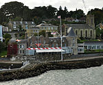 More images
|
| 88 and 89 High Street | Cowes, Isle of Wight | House | Late 18th century | 17 August 1951 | SZ4963796199 50°45′48″N 1°17′51″W / 50.763266°N 1.297572°W |
1222954 | Upload Photo |
| Former Stables at Osborne House | Osborne House, East Cowes, Isle of Wight | Naval College | Converted 1903-4 | 23 January 1987 | SZ5127394653 50°44′57″N 1°16′29″W / 50.749223°N 1.274593°W |
1255100 | 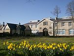 More images
|
| Landing House | Norris Estate, East Cowes, Isle of Wight | Landing House | 1855-6 | 5 July 2000 | SZ5239995481 50°45′24″N 1°15′31″W / 50.756568°N 1.258516°W |
1389288 | Upload Photo |
| Precinct Walls of Old Quarr Abbey | Binstead, Fishbourne, Isle of Wight | Abbey | Probably 1131 | 18 May 1972 | SZ5677692767 50°43′54″N 1°11′49″W / 50.731753°N 1.196888°W |
1234997 |  |
| Afton Manor | Afton, Isle of Wight | House | c. 1725 | 18 January 1967 | SZ3485186836 50°40′49″N 1°30′29″W / 50.680145°N 1.508092°W |
1219355 |  |
| All Saints Church | Freshwater, Isle of Wight | Parish Church | Late 12th century | 18 January 1967 | SZ3470487305 50°41′04″N 1°30′36″W / 50.684371°N 1.510129°W |
1209349 |  More images
|
| Fort Albert | Cliff End, Freshwater, Isle of Wight | House | 1970s-1980s | 28 March 1994 | SZ3296089072 50°42′01″N 1°32′05″W / 50.700362°N 1.534657°W |
1291552 |  More images
|
| Gatcombe House | Gatcombe, Isle of Wight | Country House | 1751 | 21 July 1951 | SZ4929185001 50°39′45″N 1°18′14″W / 50.662603°N 1.30397°W |
1209216 |  More images
|
| Sheat Manor | Gatcombe, Isle of Wight | Garage | C20 | 21 July 1951 | SZ4937284487 50°39′29″N 1°18′10″W / 50.657974°N 1.302892°W |
1209219 |  More images
|
| Woodlands Vale, including attached rose arches, forecourt balustrading, terrace walling, alcove, pergola, steps, planters and ponds | Nettlestone and Seaview, Isle of Wight | House | 1840-50 | 18 May 1972 | SZ6129091697 50°43′18″N 1°07′59″W / 50.721674°N 1.133112°W |
1234364 | Upload Photo |
| Apollo Theatre | Newport, Isle of Wight | Theatre | 1804 | 1 October 1953 | SZ5005989145 50°41′59″N 1°17′33″W / 50.699801°N 1.292545°W |
1276890 | 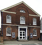 More images
|
| Bellcroft House | Newport, Isle of Wight | Apartment | 1953 | 1 October 1953 | SZ5097789411 50°42′08″N 1°16′46″W / 50.702113°N 1.279511°W |
1233835 | 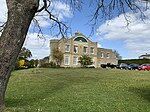 More images
|
| Country Club, Old Literary Institute | Newport, Isle of Wight | House | 1811 | 1 October 1953 | SZ4987189135 50°41′59″N 1°17′43″W / 50.699727°N 1.295208°W |
1365287 | 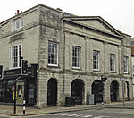 |
| God's Providence House | Newport, Isle of Wight | House | Late 17th century | 1 October 1953 | SZ5000389122 50°41′59″N 1°17′36″W / 50.699599°N 1.293341°W |
1365277 |  More images
|
| Roman Catholic Church of St Thomas of Canterbury | Newport, Isle of Wight | Roman Catholic Church | 1791 | 1 February 1972 | SZ4970489050 50°41′56″N 1°17′51″W / 50.698977°N 1.297584°W |
1232851 |  More images
|
| The Guildhall | Newport, Isle of Wight | Guildhall | 1819 | 1 October 1953 | SZ5001889217 50°42′02″N 1°17′35″W / 50.700452°N 1.293116°W |
1278563 |  More images
|
| The Old Grammar School | Newport, Isle of Wight | House | 1614 | 1 February 1972 | SZ4978189218 50°42′02″N 1°17′47″W / 50.700481°N 1.296471°W |
1034526 |  More images
|
| Church of St John the Baptist | Niton, Niton and Whitwell, Isle of Wight | Parish Church | 11th century | 18 January 1967 | SZ5052176771 50°35′19″N 1°17′16″W / 50.588493°N 1.287687°W |
1209258 |  More images
|
| Church of St Mary and St Rhadegund | Whitwell, Niton and Whitwell, Isle of Wight | Parish Church | 1967 | 18 January 1967 | SZ5217777773 50°35′50″N 1°15′51″W / 50.597358°N 1.264156°W |
1292740 |  More images
|
| Church of All Saints | Ryde, Isle of Wight | Church | 1867/72 | 24 October 1950 | SZ5890192299 50°43′38″N 1°10′01″W / 50.727334°N 1.166856°W |
1274824 | 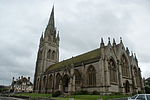 More images
|
| Church of St Michael and All Angels | Swanmore, Ryde, Isle of Wight | Church | 1861/63 | 18 May 1972 | SZ5876891387 50°43′09″N 1°10′08″W / 50.719147°N 1.168885°W |
1239466 | 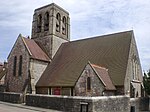 More images
|
| The Royal Victoria Arcade | Ryde, Isle of Wight | Shopping Arcade | 1835-1836 | 24 October 1950 | SZ5921892746 50°43′53″N 1°09′44″W / 50.731321°N 1.162293°W |
1239106 |  More images
|
| Ningwood Manor House | Shalfleet, Isle of Wight | Manor House | c. 1650 | 18 January 1967 | SZ4015288797 50°41′51″N 1°25′58″W / 50.697438°N 1.432854°W |
1209391 | Upload Photo |
| Shalfleet Manor | Shalfleet, Isle of Wight | Manor House | Late 16th century | 2 August 1957 | SZ4141089391 50°42′10″N 1°24′54″W / 50.702691°N 1.414977°W |
1292685 | Upload Photo |
| Church of St Blasius | Shanklin, Isle of Wight | Parish Church | 1853 | 14 March 1949 | SZ5784880555 50°37′19″N 1°11′01″W / 50.62184°N 1.183606°W |
1034290 |  More images
|
| Barn at Wolverton Manor | Shorwell, Isle of Wight | Barn | 17th century | 18 January 1967 | SZ4528482364 50°38′21″N 1°21′40″W / 50.639215°N 1.360981°W |
1220337 | Upload Photo |
| Billingham Manor | Emmett Hill, Shorwell, Isle of Wight | House | 1631 | 21 July 1951 | SZ4860281899 50°38′05″N 1°18′51″W / 50.634767°N 1.314124°W |
1291212 | Upload Photo |
| Church of St James | Kingston, Shorwell, Isle of Wight | Parish Church | 13th century | 18 January 1967 | SZ4788481299 50°37′46″N 1°19′28″W / 50.629431°N 1.324353°W |
1209403 | 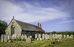 More images
|
| Kingston Manor | Kingston, Shorwell, Isle of Wight | Manor House | Early 17th century | 21 July 1951 | SZ4781881305 50°37′46″N 1°19′31″W / 50.629491°N 1.325285°W |
1291119 | Upload Photo |
| Westcourt Manor | Shorwell, Isle of Wight | Manor House | c. 1500 | 21 July 1951 | SZ4517682752 50°38′34″N 1°21′45″W / 50.642713°N 1.362461°W |
1291026 |  More images
|
| Weston Manor | Totland, Isle of Wight | House | 1869-70 | 28 March 1994 | SZ3263586100 50°40′25″N 1°32′22″W / 50.673654°N 1.53952°W |
1209416 | Upload Photo |
| Church of St Boniface (old Church) | Bonchurch, Ventnor, Isle of Wight | Church | C12/C13 | 30 March 1951 | SZ5778778023 50°35′57″N 1°11′06″W / 50.599078°N 1.184862°W |
1224516 |  More images
|
| Church of St Lawrence | St Lawrence, Ventnor, Isle of Wight | Church | 1878 | 15 July 1976 | SZ5376076575 50°35′11″N 1°14′31″W / 50.586442°N 1.241965°W |
1266331 |  More images
|
| East Dene, Workers Travel Association Guest House | Ventnor, Isle of Wight | Guest House | 1951 | 30 March 1951 | SZ5775578136 50°36′00″N 1°11′07″W / 50.600097°N 1.185297°W |
1224413 | Upload Photo |
| Holy Trinity Church | Ventnor, Isle of Wight | Church | 1860-62 | 15 July 1976 | SZ5694777853 50°35′51″N 1°11′48″W / 50.597632°N 1.196756°W |
1343326 |  More images
|
| Lisle Combe | St Lawrence, Ventnor, Isle of Wight | Cottage Ornee | Early 19th century | 15 July 1976 | SZ5427576777 50°35′18″N 1°14′05″W / 50.58821°N 1.234661°W |
1225493 | Upload Photo |
| Madeira Hall Hotel | Ventnor, Isle of Wight | House | Circa 1800-1820 | 15 July 1976 | SZ5713177910 50°35′53″N 1°11′39″W / 50.598126°N 1.194147°W |
1075788 | Upload Photo |
| Old Church of St Lawrence | St Lawrence, Ventnor, Isle of Wight | Church | 12th century | 30 March 1951 | SZ5362776652 50°35′14″N 1°14′38″W / 50.587146°N 1.243832°W |
1225276 | More images
|
| The Cottage, St Lawrence Well | Ventnor, Isle of Wight | House | 17th century or 18th century | 15 July 1976 | SZ5413176721 50°35′16″N 1°14′12″W / 50.58772°N 1.236704°W |
1225494 | Upload Photo |
| The Old Manor House | Ventnor, Isle of Wight | Farmhouse | Earlier building | 30 March 1951 | SZ5621277583 50°35′43″N 1°12′26″W / 50.595275°N 1.20718°W |
1266597 | Upload Photo |
| Coburg | Whippingham, Isle of Wight | Estate Cottage | c. 1853 | 17 August 1951 | SZ5233993407 50°44′17″N 1°15′35″W / 50.737924°N 1.25966°W |
1223080 | Upload Photo |
| Church of St Edmund | Wootton Bridge, Isle of Wight | Church | 13th century | 1 October 1953 | SZ5413892646 50°43′51″N 1°14′03″W / 50.730917°N 1.23428°W |
1229657 |  More images
|
| Freemantle Lodge Gateway to Appuldurcombe | Wroxall, Isle of Wight | Gate | Late 18th century | 18 January 1967 | SZ5403380767 50°37′27″N 1°14′15″W / 50.624111°N 1.2375°W |
1292007 |  More images
|
| Bugle Hotel | Yarmouth, Isle of Wight | Hotel | Late 16th century | 18 January 1967 | SZ3545689735 50°42′22″N 1°29′57″W / 50.706177°N 1.499252°W |
1209437 | 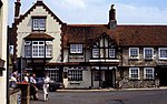 More images
|
| Church of St Swithin (old) | Yarmouth, Isle of Wight | Parish Church | 13th century | 21 July 1951 | SZ3671189139 50°42′03″N 1°28′54″W / 50.70074°N 1.481539°W |
1209421 | 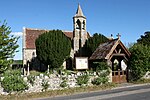 More images
|
| Parish Church of St Jame | Yarmouth, Isle of Wight | Parish Church | Medieval | 18 January 1967 | SZ3546589663 50°42′20″N 1°29′57″W / 50.705529°N 1.499131°W |
1209433 |  More images
|
| The George Hotel | Yarmouth, Isle of Wight | House | 1700-1710 | 18 January 1967 | SZ3539089762 50°42′23″N 1°30′01″W / 50.706424°N 1.500184°W |
1209432 |  More images
|
| Thorley Manor | Thorley, Yarmouth, Isle of Wight | Manor House | c. 1712 | 18 January 1967 | SZ3677089105 50°42′02″N 1°28′51″W / 50.700431°N 1.480707°W |
1209424 |  More images
|
See also edit
![]() Media related to Grade II* listed buildings on the Isle of Wight at Wikimedia Commons
Media related to Grade II* listed buildings on the Isle of Wight at Wikimedia Commons
Notes edit
- ^ The date given is the date used by Historic England as significant for the initial building or that of an important part in the structure's description.
- ^ Sometimes known as OSGB36, the grid reference is based on the British national grid reference system used by the Ordnance Survey.
- ^ The "List Entry Number" is a unique number assigned to each listed building and scheduled monument by Historic England.
References edit
External links edit
- English Heritage Images of England