
KNOWPIA
WELCOME TO KNOWPIA

Grade I listed buildings in Craven 
Summary
There are over 9,000 Grade I listed buildings in England. This page is a list of these buildings in the Craven District of North Yorkshire.
List of buildings edit
| Name | Location | Type | Completed [note 1] | Date designated | Grid ref.[note 2] Geo-coordinates | Notes | Entry number [note 3] | Image | Ref. |
|---|---|---|---|---|---|---|---|---|---|
| Barden Church | Barden | Chapel | 16th century | 10 September 1954 | SE0511857171 54°00′38″N 1°55′24″W / 54.010532°N 1.923394°W |
1131761 |  Upload Photo |
[1] | |
| Barden Tower | Barden | Tower house | Mid-16th century | 10 September 1954 | SE0509357198 54°00′39″N 1°55′26″W / 54.010775°N 1.923775°W |
Tower house built by Henry Clifford, 17th century remodelling by Lady Anne Clifford | 1317012 |  More images |
[2][3] |
| Priest's House | Barden | House | 16th century | 10 September 1954 | SE0511057163 54°00′38″N 1°55′25″W / 54.01046°N 1.923517°W |
1317013 |  More images |
[4] | |
| Beamsley Hospital (north range) | Beamsley | Chapel | 17th century | 10 September 1954 | SE0822953089 53°58′26″N 1°52′34″W / 53.973805°N 1.876032°W |
Hospital and chapel. Chapel built by Lady Margaret Russell | 1131765 | 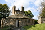 More images |
[5] |
| Church of St Mary, Bolton Abbey | Bolton Abbey | Church | Late 12th century | 10 September 1954 | SE0739854203 53°59′02″N 1°53′19″W / 53.983829°N 1.888675°W |
1166745 |  More images |
[1][6] | |
| Priory of St Mary | Bolton Abbey | Augustinian monastery | 12th century | 10 September 1954 | SE0741754182 53°59′01″N 1°53′18″W / 53.98364°N 1.888386°W |
Scheduled ancient monument No 610 | 1131775 |  More images |
[7] |
| Broughton Hall | Broughton | Country house | 1597 | 10 September 1954 | SD9428250844 53°57′13″N 2°05′19″W / 53.953658°N 2.08862°W |
1132296 |  More images |
[8] | |
| Church of All Saints | Broughton | Church | Early 16th century | 10 September 1954 | SD9340650359 53°56′57″N 2°06′07″W / 53.949288°N 2.101958°W |
1132291 |  More images |
[8] | |
| Church of St Wilfrid | Burnsall | Church | 14th century | 10 September 1954 | SE0325761515 54°02′59″N 1°57′06″W / 54.049589°N 1.951746°W |
1131740 | 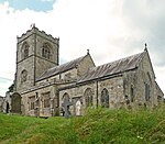 More images |
||
| Farnhill Hall | Main Street, Farnhill | Fortified manor house | 15th century | 10 September 1954 | SE0032946468 53°54′52″N 1°59′47″W / 53.91436°N 1.996477°W |
15th century substantially altered 16th and 19th century | 1316997 | Upload Photo |
[8] |
| Church of St Alkeda | Giggleswick | Church | Late 14th/early 15th century | 20 February 1958 | SD8115164084 54°04′20″N 2°17′22″W / 54.072338°N 2.289538°W |
Late 14th century to early 15th century and tower from the mid 15th century | 1157303 |  More images |
[8] |
| Church of St Oswald | Horton in Ribblesdale | Parish church | 12th century | 20 February 1958 | SD8101072116 54°08′40″N 2°17′32″W / 54.144519°N 2.2922°W |
1132264 |  More images |
||
| Church of St Andrew | Kildwick | Church | 14th century | 10 September 1954 | SE0114445893 53°54′33″N 1°59′03″W / 53.909192°N 1.984072°W |
1132175 |  More images |
[8][9] | |
| Kildwick Bridge | Kildwick | Bridge | 1305–13 | 10 September 1954 | SE0111545699 53°54′27″N 1°59′04″W / 53.907448°N 1.984514°W |
1167718 |  More images |
[8] | |
| Church of St Michael the Archangel | Kirkby Malham | Parish church | Late 15th century | 20 February 1958 | SD8940360997 54°02′41″N 2°09′48″W / 54.044831°N 2.163325°W |
1132389 |  More images |
||
| Lawkland Hall and garden walls | Lawkland | House | Late 16th century | 20 February 1958 | SD7765065922 54°05′19″N 2°20′35″W / 54.088716°N 2.343174°W |
West wing late 16th century, extended late 17th century including hall and east wing | 1132378 |  More images |
[8] |
| Church of St Mary the Virgin | Long Preston | Church | Late 14th/early 15th century | 20 February 1958 | SD8371558090 54°01′07″N 2°15′00″W / 54.018555°N 2.250032°W |
1157818 |  More images |
||
| The Folly | Victoria Street, Settle | House | 1670s | 20 February 1958 | SD8207563568 54°04′04″N 2°16′31″W / 54.067734°N 2.275387°W |
Architect Richard Preston | 1166834 |  More images |
[8] |
| Church of the Holy Trinity | High Street, Skipton | Church | 14th century | 28 April 1952 | SD9903951914 53°57′48″N 2°00′58″W / 53.963307°N 2.016135°W |
1131877 |  More images |
[8] | |
| Former chapel at Skipton Castle | The Bailey, Skipton | Chapel | Probably 13th century | 28 April 1952 | SD9904051982 53°57′50″N 2°00′58″W / 53.963918°N 2.01612°W |
Former chapel that, when in use, was dedicated to St. John the Evangelist. Freestanding rectangular building within the Bailey of the Castle. | 1131902 |  More images |
[8][10][11] |
| Outer gatehouse to Skipton Castle | The Bailey, Skipton | Gatehouse | 14th century | 28 April 1952 | SD9908651931 53°57′48″N 2°00′56″W / 53.96346°N 2.015419°W |
This is the public entrance to the castle | 1131901 |  More images |
[8] |
| Skipton Castle | The Bailey, Skipton | Castle | Mostly early 14th century | 28 April 1952 | SD9911651998 53°57′51″N 2°00′54″W / 53.964062°N 2.014962°W |
1316962 |  More images |
[8] | |
| Church of St Mary | Thornton in Craven | Church | Early 16th century | 10 September 1954 | SD9016148345 53°55′52″N 2°09′05″W / 53.931135°N 2.151335°W |
1167634 |  More images |
See also edit
- Grade I listed buildings in North Yorkshire
- Grade I listed buildings in Selby (district)
- Grade I listed buildings in Harrogate (borough)
- Grade I listed buildings in Richmondshire
- Grade I listed buildings in Hambleton
- Grade I listed buildings in Ryedale
- Grade I listed buildings in Scarborough (borough)
- Grade I listed buildings in the City of York
- Grade I listed buildings in Redcar and Cleveland
- Grade I listed buildings in Middlesbrough (borough)
- Grade I listed buildings in Stockton-on-Tees
- Grade II* listed buildings in Craven
Notes edit
- ^ The date given is the date used by Historic England as significant for the initial building or that of an important part in the structure's description.
- ^ Sometimes known as OSGB36, the grid reference is based on the British national grid reference system used by the Ordnance Survey.
- ^ The "List Entry Number" is a unique number assigned to each listed building and scheduled monument by Historic England.
References edit
- ^ a b Historic England. "Details from listed building database (1131761)". National Heritage List for England. Retrieved 16 January 2009.
- ^ Historic England. "Barden Tower (Grade I) (1317012)". National Heritage List for England. Retrieved 15 May 2017.
- ^ Historic England. "Details from listed building database (1317012)". National Heritage List for England. Retrieved 16 January 2009.
- ^ Historic England. "Details from listed building database (1317013)". National Heritage List for England. Retrieved 16 January 2009.
- ^ Historic England. "Details from listed building database (1131765)". National Heritage List for England. Retrieved 16 January 2009.
- ^ Historic England. "Church of St Mary (Grade I) (1166745)". National Heritage List for England. Retrieved 15 May 2017.
- ^ Historic England. "Details from listed building database (1131775)". National Heritage List for England. Retrieved 16 January 2009.
- ^ a b c d e f g h i j k l "Listed Buildings in Craven District Outside YDNP" (PDF). Craven District Council. 28 April 2008. Archived from the original (PDF) on 27 September 2011. Retrieved 15 January 2009.
- ^ Davies, Caroline (16 March 2008). "Parishes at war over plans to rip out pews: Archers-style rifts arise as vicars try to create space for concerts and yoga". The Observer from the guardian.co.uk site. Retrieved 15 January 2009.
- ^ Historic England. "Details from listed building database (1131902)". National Heritage List for England. Retrieved 17 January 2009.
- ^ "3D Castle Plan". Skipton Castle. 28 April 2008. Retrieved 17 January 2009.
External links edit
![]() Media related to Grade I listed buildings in Craven at Wikimedia Commons
Media related to Grade I listed buildings in Craven at Wikimedia Commons