


Summary
There are many Grade I listed buildings in St Edmundsbury, a former non-metropolitan district and borough in the county of Suffolk in England that takes its name from the town of Bury St Edmunds.
In the United Kingdom, the term listed building refers to a building or other structure officially designated as being of "exceptional architectural or historic special interest"; Grade I structures are those considered to be "buildings of "exceptional interest, sometimes considered to be internationally important. Just 2.5% of listed buildings are Grade I." The total number of listed buildings in England is 372,905.[1] Listing was begun by a provision in the Town and Country Planning Act 1947. Listing a building imposes severe restrictions on what the owner might wish to change or modify in the structure or its fittings. In England, the authority for listing under the Planning (Listed Buildings and Conservation Areas) Act 1990[2] rests with English Heritage, a non-departmental public body sponsored by the Department for Culture, Media and Sport.
St Edmundsbury is a local government district with its administrative headquarters at Bury St Edmunds, which is the third city by size in Suffolk. The other towns in the area are Clare and Haverhill. The number of inhabitants of the area is 102,900 with a density of 157 inhabitants per km2. The whole district is parished.
List edit
| Name | Location | Type | Completed [note 1] | Date designated | Grid ref.[note 2] Geo-coordinates | Notes | Entry number [note 3] | Image |
|---|---|---|---|---|---|---|---|---|
| Church of St Peter | Ampton | Parish Church | 15th century | 14 July 1955 | TL8661471181 52°18′25″N 0°44′09″E / 52.307027°N 0.735841°E |
[3] | 1198006 |  More images
|
| Church of St Peter & St Paul | Bardwell | Parish Church | 15th century | 14 July 1955 | TL9410673620 52°19′35″N 0°50′49″E / 52.326332°N 0.846996°E |
[4] | 1376891 | 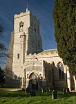 More images
|
| Church of St Andrew | Barningham | Church | 14th century | 14 July 1955 | TL9678576892 52°21′17″N 0°53′17″E / 52.354758°N 0.88817°E |
[5] | 1376995 |  More images
|
| Church of All Saints | Barrow | Church | Norman | 14 July 1955 | TL7602764619 52°15′06″N 0°34′38″E / 52.251586°N 0.577303°E |
[6] | 1376863 |  More images
|
| Coldham Hall | Stanningfield | Country House | 1574 | 14 July 1955 | TL8641455860 52°10′10″N 0°43′28″E / 52.16951°N 0.724468°E |
[7] | 1229768 |  More images
|
| St Nicholas' Church | Stanningfield | Church | 15th century | 14 July 1955 | TL8773156346 52°10′24″N 0°44′38″E / 52.173429°N 0.743971°E |
[8] | 1229767 | 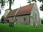 More images
|
| St Georges's Church | Bradfield St George | Church | c. 1500 | 14 July 1955 | TL9072159932 52°12′17″N 0°47′23″E / 52.204606°N 0.789658°E |
[9] | 1228901 |  More images
|
| Brockley Hall | Brockley | Farmhouse | 14th century | 27 January 1984 | TL8265355526 52°10′04″N 0°40′10″E / 52.167767°N 0.669358°E |
[10] | 1229174 |  More images
|
| Abbey Gate and Gatehouse | Bury St Edmunds | Abbey | 1353 | 7 August 1952 | TL8554464220 52°14′42″N 0°42′59″E / 52.244879°N 0.716339°E |
[11] | 1375545 | 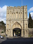 More images
|
| Abbots Bridge and adjoining east precinct wall | Bury St Edmunds | Abbey | 14th century | 7 August 1952 | TL8578864356 52°14′46″N 0°43′12″E / 52.246018°N 0.719984°E |
[12] | 1375552 |  More images
|
| Alwyne House and Alwyne Cottage | Bury St Edmunds | House | 19th century | 7 August 1952 | TL8569264313 52°14′44″N 0°43′07″E / 52.245664°N 0.718555°E |
[13] | 1375554 |  More images
|
| Athenaeum and attached railings | Bury St Edmunds | House | 17th century | 7 August 1952 | TL8553064136 52°14′39″N 0°42′58″E / 52.244129°N 0.716088°E |
[14] | 1376999 |  More images
|
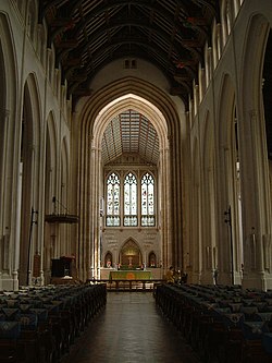
| Cathedral Church of St James | Bury St Edmunds | Cathedral | 16th century | 7 August 1952 | TL8559764117 52°14′38″N 0°43′01″E / 52.243936°N 0.717058°E |
[15] | 1377001 |  More images
|
| Church of St Mary | Bury St Edmunds | Church | 15th century | 7 August 1952 | TL8560463945 52°14′33″N 0°43′01″E / 52.242389°N 0.717066°E |
[16] | 1342765 |  More images
|
| Manor House | Bury St Edmunds | House | 1738 | 7 August 1952 | TL8573763933 52°14′32″N 0°43′08″E / 52.242236°N 0.719005°E |
[17] | 1022551 |  More images
|
| Market Cross | Bury St Edmunds | Town Hall | 1780 | 7 August 1952 | TL8525364308 52°14′45″N 0°42′44″E / 52.245767°N 0.71213°E |
[18] | 1076930 |  More images
|
| Moyse's Hall | Bury St Edmunds | Merchants House | 12th century | 7 August 1952 | TL8530164370 52°14′47″N 0°42′46″E / 52.246307°N 0.712866°E |
[19] | 1076931 |  More images
|
| Norman Tower | Bury St Edmunds | Tower | 1120-1148 | 7 August 1952 | TL8557264078 52°14′37″N 0°43′00″E / 52.243594°N 0.716671°E |
[20] | 1375555 | 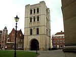 More images
|
| North wall of Great Court of the Abbey | Bury St Edmunds | Wall | 12th century | 7 August 1952 | TL8558364292 52°14′44″N 0°43′01″E / 52.245512°N 0.716949°E |
[21] | 1375553 | 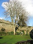 More images
|
| Northgate House | Bury St Edmunds | Timber Framed House | 18th century | 7 August 1952 | TL8555864450 52°14′49″N 0°43′00″E / 52.246939°N 0.71667°E |
[22] | 1022615 |  More images
|
| Numbers 1, 1a, 2 and 3 West Front and Sampsons Tower | Bury St Edmunds | Abbey | c. 1200 | 7 August 1952 | TL8564664094 52°14′37″N 0°43′04″E / 52.243713°N 0.717762°E |
[23] | 1375539 |  More images
|
| Precinct wall of former vineyard along north side of Kevelaer Way | Bury St Edmunds | Wall | 12th century | 7 August 1952 | TL8598664051 52°14′36″N 0°43′22″E / 52.243212°N 0.722713°E |
[24] | 1375550 |  Upload Photo |
| Precinct wall on south to east of Shire Hall (Shire Hall not included) | Bury St Edmunds | Wall | 12th century | 7 August 1952 | TL8584363983 52°14′34″N 0°43′14″E / 52.242649°N 0.720583°E |
[25] | 1375549 | Upload Photo |
| Precinct wall to north of the former Abbey of St Edmund | Bury St Edmunds | Wall | 12th century | 7 August 1952 | TL8573764362 52°14′46″N 0°43′09″E / 52.246089°N 0.719241°E |
[26] | 1375548 | More images
|
| Precinct wall to north of the Abbey Gate | Bury St Edmunds | Wall | 14th century | 7 August 1952 | TL8553664246 52°14′42″N 0°42′58″E / 52.245115°N 0.716236°E |
[27] | 1375546 |  More images
|
| Precinct wall to south of the Abbey Gate | Bury St Edmunds | Wall | 14th century | 7 August 1952 | TL8554664199 52°14′41″N 0°42′59″E / 52.244689°N 0.716357°E |
[28] | 1375547 | 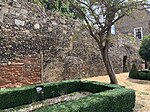 |
| Provosts House and Number 4 Churchyard (Clopton Cottage) | Bury St Edmunds | House | c. 1730 | 7 August 1952 | TL8569964076 52°14′37″N 0°43′07″E / 52.243533°N 0.718528°E |
[29] | 1375558 | 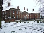 More images
|
| Ruins of Abbey Church of St Edmund | Bury St Edmunds | Abbey | 12th century | 7 August 1952 | TL8575064123 52°14′38″N 0°43′09″E / 52.243938°N 0.7193°E |
[30] | 1375540 | 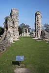 More images
|
| Ruins of abbey dovecote and part of wall | Bury St Edmunds | Abbey | 12th century | 12 July 1972 | TL8576764277 52°14′43″N 0°43′11″E / 52.245315°N 0.719633°E |
[31] | 1375544 |  More images
|
| Ruins of Chapel of the Charnel | Bury St Edmunds | Charnel House | Late 13th century | 7 August 1952 | TL8570264004 52°14′34″N 0°43′07″E / 52.242886°N 0.718532°E |
[32] | 1375556 |  More images
|
| Ruins of Hall of Pleas and south wall of Great Court | Bury St Edmunds | Abbey | 13th century | 7 August 1952 | TL8558064176 52°14′40″N 0°43′01″E / 52.244471°N 0.716842°E |
[33] | 1375543 |  |
| Ruins to east and north of abbey church | Bury St Edmunds | Abbey | 12th century | 7 August 1952 | TL8574764163 52°14′39″N 0°43′09″E / 52.244298°N 0.719278°E |
[34] | 1375541 |  More images
|
| Ruins to the north of the cloister | Bury St Edmunds | Abbey | 12th century | 7 August 1952 | TL8571964222 52°14′41″N 0°43′08″E / 52.244838°N 0.7189°E |
[35] | 1375542 |  |
| St Saviours Hospital | Bury St Edmunds | Chapel | 1185 | 7 August 1952 | TL8535665255 52°15′15″N 0°42′51″E / 52.254236°N 0.714156°E |
[36] | 1363685 |  More images
|
| Bury St Edmunds Guildhall and attached railings | Bury St Edmunds | Guildhall | 15th century | 7 August 1952 | TL8526864059 52°14′37″N 0°42′44″E / 52.243526°N 0.712213°E |
[37] | 1363726 | 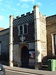 More images
|
| Theatre Royal | Bury St Edmunds | Theatre | 1819 | 7 August 1952 | TL8561863739 52°14′26″N 0°43′02″E / 52.240534°N 0.717158°E |
[38] | 1142285 |  More images
|
| Unitarian Chapel | Bury St Edmunds | Presbyterian Chapel | 1711 | 7 August 1952 | TL8536764057 52°14′37″N 0°42′49″E / 52.243474°N 0.71366°E |
[39] | 1248301 |  More images
|
| Wall to east of former abbey vineyard | Bury St Edmunds | Wall | 19th century | 7 August 1952 | TL8599064244 52°14′42″N 0°43′22″E / 52.244944°N 0.722877°E |
[40] | 1375551 | Upload Photo |
| Northgate Street, Nos. 9-11 | Bury St Edmunds | Open Hall House | 15th century | 7 August 1952 | TL8555464472 52°14′50″N 0°43′00″E / 52.247138°N 0.716624°E |
[41] | 1022624 |  |
| Guildhall Street, No 81 | Bury St Edmunds | House | 18th century | 7 August 1952 | TL8524264068 52°14′37″N 0°42′43″E / 52.243615°N 0.711838°E |
[42] | 1363718 |  |
| Church of St Mary | Cavendish | Church | 15th century | 19 December 1961 | TL8051346549 52°05′16″N 0°38′00″E / 52.087849°N 0.633343°E |
[43] | 1031774 |  More images
|
| Church of St John the Baptist | Chevington | Church | c. 1500 | 14 July 1955 | TL7887960122 52°12′37″N 0°37′00″E / 52.210279°N 0.61666°E |
[44] | 1186968 |  More images
|
| Chapel to Clare Priory | Clare | Chapel | 1248 | 19 December 1961 | TL7700045000 52°04′30″N 0°34′53″E / 52.07507°N 0.581321°E |
[45] | 1285828 |  More images
|
| Clare Priory | Clare | Priory | 1604 | 19 December 1961 | TL7696444990 52°04′30″N 0°34′51″E / 52.074992°N 0.580791°E |
[46] | 1376670 |  More images
|
| Cliftons | Clare | House | 16th century | 19 December 1961 | TL7674945054 52°04′32″N 0°34′40″E / 52.075635°N 0.57769°E |
[47] | 1180531 |  More images
|
| Nethergate Hotel | Clare | House | 1644 | 19 December 1961 | TL7686645130 52°04′35″N 0°34′46″E / 52.07628°N 0.579435°E |
[48] | 1031719 |  More images
|
| Parish Church of SS Peter and Paul | Clare | Church | 15th century | 19 December 1961 | TL7696445461 52°04′45″N 0°34′52″E / 52.079222°N 0.581035°E |
[49] | 1194114 |  More images
|
| The Ancient House | Clare | Timber Framed House | 15th century | 20 February 1958 | TL7694445415 52°04′44″N 0°34′51″E / 52.078815°N 0.58072°E |
[50] | 1376700 |  More images
|
| Church of St Mary | Coney Weston | Parish Church | 14th century | 14 July 1955 | TL9715978395 52°22′05″N 0°53′40″E / 52.368118°N 0.894537°E |
[51] | 1031174 |  More images
|
| Church of St Margaret | Cowlinge | Church | 14th century | 19 December 1961 | TL7184654931 52°09′57″N 0°30′40″E / 52.165891°N 0.511205°E |
[52] | 1376713 |  More images
|
| The Iron Bridge, Culford Park | Culford | Bridge | c. 1803 | 15 May 1996 | TL8279970401 52°18′05″N 0°40′46″E / 52.301305°N 0.679527°E |
[53] | 1269105 |  More images
|
| Church of St Nicholas | Denston | Church | 15th century | 19 December 1961 | TL7601752954 52°08′49″N 0°34′16″E / 52.146822°N 0.571101°E |
[54] | 1031706 |  More images
|
| Church of St Genevieve | Euston | Church | 1676 | 14 July 1955 | TL9003478479 52°22′17″N 0°47′24″E / 52.371388°N 0.790066°E |
[55] | 1376962 | 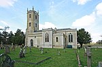 More images
|
| Church of St Peter | Fakenham Magna | Parish Church | 15th century | 14 July 1955 | TL9105276614 52°21′15″N 0°48′14″E / 52.354288°N 0.80394°E |
[56] | 1376921 |  More images
|
| Church of All Saints | Fornham All Saints | Parish Church | 12th century | 14 July 1955 | TL8375267623 52°16′34″N 0°41′31″E / 52.276039°N 0.691973°E |
[57] | 1031300 |  More images
|
| Church of the Holy Innocents | Great Barton | Church | 13th century | 14 July 1955 | TL8899166042 52°15′36″N 0°46′04″E / 52.260068°N 0.767785°E |
[58] | 1376986 |  More images
|
| Church of St Peter | Great Livermere | Parish Church | 13th century | 14 July 1955 | TL8851771384 52°18′30″N 0°45′50″E / 52.308201°N 0.763833°E |
[59] | 1283741 | 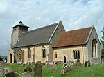 More images
|
| Church of St Thomas a Becket | Great Whelnetham | Church | 14th century | 14 July 1955 | TL8781359343 52°12′01″N 0°44′49″E / 52.200314°N 0.746828°E |
[60] | 1278722 |  More images
|
| Church of St Mary | Hawkedon | Church | 15th century | 19 December 1961 | TL7973552968 52°08′45″N 0°37′31″E / 52.145751°N 0.625387°E |
[61] | 1031651 |  More images
|
| Swan's Hall | Hawkedon | Jettied House | 16th century | 19 December 1961 | TL7968451205 52°07′48″N 0°37′25″E / 52.129934°N 0.623711°E |
[62] | 1031656 |  More images
|
| Thurston End Hall | Hawkedon | House | 1607 | 19 December 1961 | TL7944851855 52°08′09″N 0°37′14″E / 52.135849°N 0.62061°E |
[63] | 1031655 |  More images
|
| All Saints Church | Hawstead | Church | 16th century | 14 July 1955 | TL8557959258 52°12′01″N 0°42′51″E / 52.200307°N 0.714131°E |
[64] | 1279106 | 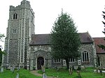 More images
|
| Church of St John Lateran | Hengrave | Church | 14th century | 14 July 1955 | TL8244968576 52°17′06″N 0°40′24″E / 52.285031°N 0.673412°E |
[65] | 1180513 | 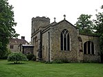 More images
|
| Hengrave Hall | Hengrave | Country House | 1538 | 14 July 1955 | TL8239468541 52°17′05″N 0°40′21″E / 52.284735°N 0.672588°E |
[66] | 1031423 |  More images
|
| Church of All Saints | Honington | Parish Church | 14th century | 14 July 1955 | TL9134274573 52°20′09″N 0°48′25″E / 52.33586°N 0.807031°E |
[67] | 1182036 |  More images
|
| Church of All Saints | Hopton | Parish Church | 14th century | 14 July 1955 | TL9938779039 52°22′23″N 0°55′39″E / 52.373095°N 0.927599°E |
[68] | 1198789 |  More images
|
| Ickworth House | Ickworth | Country House | 1829 | 14 July 1955 | TL8161861333 52°13′13″N 0°39′26″E / 52.22026°N 0.657351°E |
[69] | 1205300 | 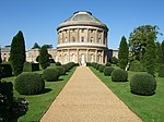 More images
|
| Church of St Mary | Ixworth | Parish Church | 15th century | 3 February 1950 | TL9314070390 52°17′52″N 0°49′52″E / 52.29767°N 0.830987°E |
[70] | 1180826 |  More images
|
| Ixworth Abbey | Ixworth | House | 17th century | 14 July 1955 | TL9298270435 52°17′53″N 0°49′43″E / 52.29813°N 0.828699°E |
[71] | 1031475 | 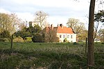 More images
|
| Church of All Saints | Ixworth Thorpe | Church | 16th century | 14 July 1955 | TL9177072499 52°19′02″N 0°48′44″E / 52.317087°N 0.812123°E |
[72] | 1031461 |  More images
|
| Church of St Peter and St Paul | Kedington | Church | 15th century | 19 December 1961 | TL7050247026 52°05′43″N 0°29′15″E / 52.095305°N 0.487615°E |
[73] | 1376724 | 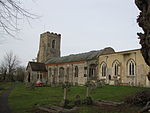 More images
|
| Church of All Saints | Little Bradley | Church | Anglo-Saxon origins | 19 December 1961 | TL6818752122 52°08′30″N 0°27′23″E / 52.141786°N 0.45637°E |
1227173 |  More images
| |
| Church of St Mary Magdalene | Little Whelnetham | Church | 16th century | 14 July 1955 | TL8886560045 52°12′23″N 0°45′45″E / 52.206259°N 0.762594°E |
[74] | 1278672 |  More images
|
| Church of St Peter | Ousden | Church | 12th century | 19 December 1961 | TL7358159590 52°12′26″N 0°32′20″E / 52.207194°N 0.53893°E |
[75] | 1227383 |  More images
|
| Church of St Mary | Pakenham | Parish Church | 12th century | 14 July 1955 | TL9298867063 52°16′04″N 0°49′37″E / 52.267849°N 0.826858°E |
[76] | 1181353 |  More images
|
| Church of St Giles | Risby | Church | 14th century | 14 July 1955 | TL8021966377 52°15′58″N 0°38′22″E / 52.266018°N 0.639582°E |
[77] | 1031432 | 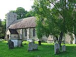 More images
|
| Church of St Mary | Rougham | Parish Church | 15th century | 14 July 1955 | TL9120062596 52°13′42″N 0°47′53″E / 52.228362°N 0.798162°E |
[78] | 1031163 |  More images
|
| Church of St Nicholas | Rushbrooke | Parish Church | 16th century | 14 July 1955 | TL8934161520 52°13′10″N 0°46′13″E / 52.219341°N 0.770375°E |
[79] | 1377019 |  More images
|
| Church of St Andrew | Sapiston | Parish Church | 12th century | 14 July 1955 | TL9205074258 52°19′58″N 0°49′02″E / 52.332784°N 0.817229°E |
[80] | 1031294 |  More images
|
| Church of All Saints | Stansfield | Church | 15th century | 19 December 1961 | TL7833452524 52°08′32″N 0°36′17″E / 52.142217°N 0.604701°E |
[81] | 1227686 | 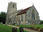 More images
|
| Purton Green Farmhouse | Stansfield | Hall House | 13th century | 20 May 1974 | TL7825853510 52°09′04″N 0°36′15″E / 52.151097°N 0.604109°E |
[82] | 1227639 |  More images
|
| Church of St John the Baptist | Stoke-by-Clare | Church | 16th century | 19 December 1955 | TL7410243342 52°03′40″N 0°32′18″E / 52.061096°N 0.538235°E |
[83] | 1235153 |  More images
|
| Church of St Margaret | Stradishall | Church | 14th century | 19 December 1961 | TL7477852570 52°08′38″N 0°33′10″E / 52.143766°N 0.552815°E |
[84] | 1235703 | 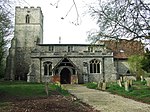 More images
|
| Church of St Nicholas | Little Saxham | Church | 14th century | 14 July 1955 | TL7992663714 52°14′32″N 0°38′02″E / 52.242198°N 0.633876°E |
[85] | 1285080 |  More images
|
| Church of St Nicholas | Thelnetham | Parish Church | c. 1300 | 14 July 1955 | TM0186178302 52°21′56″N 0°57′48″E / 52.365573°N 0.963447°E |
[86] | 1194457 |  More images
|
| Church of St Mary | Troston | Parish Church | 13th century | 14 July 1955 | TL9003172270 52°18′56″N 0°47′11″E / 52.315635°N 0.786513°E |
[87] | 1031250 |  More images
|
| West Stow Hall | West Stow | Farmhouse | 16th century | 14 July 1955 | TL8159270879 52°18′22″N 0°39′44″E / 52.305997°N 0.662103°E |
[88] | 1031269 |  More images
|
| Church of All Saints | Wickhambrook | Church | 14th century | 19 December 1961 | TL7534654444 52°09′38″N 0°33′43″E / 52.160418°N 0.562074°E |
[89] | 1264889 |  More images
|
| Gifford's Hall | Wickhambrook | Manor House | c. 1490 | 19 December 1961 | TL7708353842 52°09′16″N 0°35′14″E / 52.154457°N 0.587126°E |
[90] | 1235864 | Upload Photo |
| Church of All Saints | Wordwell | Parish Church | 11th century | 14 July 1955 | TL8280472035 52°18′58″N 0°40′50″E / 52.315977°N 0.680487°E |
[91] | 1031270 |  More images
|
See also edit
Notes edit
- ^ The date given is the date used by Historic England as significant for the initial building or that of an important part in the structure's description.
- ^ Sometimes known as OSGB36, the grid reference is based on the British national grid reference system used by the Ordnance Survey.
- ^ The "List Entry Number" is a unique number assigned to each listed building and scheduled monument by Historic England.
References edit
- ^ "Listed Buildings". English Heritage. 2010. Archived from the original on 26 January 2013. Retrieved 22 August 2011.
- ^ "Planning (Listed Buildings and Conservation Areas) Act 1990 (c. 9)". Ministry of Justice. Retrieved 28 May 2009.
- ^ Historic England. "Details from listed building database (1198006)". National Heritage List for England. Retrieved 17 July 2009.
- ^ Historic England. "Details from listed building database (1376891)". National Heritage List for England. Retrieved 19 July 2009.
- ^ Historic England. "Details from listed building database (1376995)". National Heritage List for England. Retrieved 17 July 2009.
- ^ Historic England. "Details from listed building database (1376863)". National Heritage List for England. Retrieved 17 July 2009.
- ^ Historic England. "Details from listed building database (1229768)". National Heritage List for England. Retrieved 17 July 2009.
- ^ Historic England. "Details from listed building database (1229767)". National Heritage List for England. Retrieved 17 July 2009.
- ^ Historic England. "Details from listed building database (1228901)". National Heritage List for England. Retrieved 19 July 2009.
- ^ Historic England. "Details from listed building database (1229174)". National Heritage List for England. Retrieved 17 July 2009.
- ^ Historic England. "Details from listed building database (1375545)". National Heritage List for England. Retrieved 17 July 2009.
- ^ Historic England. "Details from listed building database (1375552)". National Heritage List for England. Retrieved 17 July 2009.
- ^ Historic England. "Details from listed building database (1375554)". National Heritage List for England. Retrieved 17 July 2009.
- ^ Historic England. "Details from listed building database (1376999)". National Heritage List for England. Retrieved 17 July 2009.
- ^ Historic England. "Details from listed building database (1377001)". National Heritage List for England. Retrieved 17 July 2009.
- ^ Historic England. "Details from listed building database (1342765)". National Heritage List for England. Retrieved 17 July 2009.
- ^ Historic England. "Details from listed building database (1022551)". National Heritage List for England. Retrieved 17 July 2009.
- ^ Historic England. "Details from listed building database (1076930)". National Heritage List for England. Retrieved 17 July 2009.
- ^ Historic England. "Details from listed building database (1076931)". National Heritage List for England. Retrieved 17 July 2009.
- ^ Historic England. "Details from listed building database (1375555)". National Heritage List for England. Retrieved 17 July 2009.
- ^ Historic England. "Details from listed building database (1375553)". National Heritage List for England. Retrieved 17 July 2009.
- ^ Historic England. "Details from listed building database (1022615)". National Heritage List for England. Retrieved 17 July 2009.
- ^ Historic England. "Details from listed building database (1375539)". National Heritage List for England. Retrieved 17 July 2009.
- ^ Historic England. "Details from listed building database (1375550)". National Heritage List for England. Retrieved 17 July 2009.
- ^ Historic England. "Details from listed building database (1375549)". National Heritage List for England. Retrieved 17 July 2009.
- ^ Historic England. "Details from listed building database (1375548)". National Heritage List for England. Retrieved 17 July 2009.
- ^ Historic England. "Details from listed building database (1375546)". National Heritage List for England. Retrieved 17 July 2009.
- ^ Historic England. "Details from listed building database (1375547)". National Heritage List for England. Retrieved 17 July 2009.
- ^ Historic England. "Details from listed building database (1375558)". National Heritage List for England. Retrieved 17 July 2009.
- ^ Historic England. "Details from listed building database (1375540)". National Heritage List for England. Retrieved 17 July 2009.
- ^ Historic England. "Details from listed building database (1375544)". National Heritage List for England. Retrieved 17 July 2009.
- ^ Historic England. "Details from listed building database (1375556)". National Heritage List for England. Retrieved 17 July 2009.
- ^ Historic England. "Details from listed building database (1375543)". National Heritage List for England. Retrieved 17 July 2009.
- ^ Historic England. "Details from listed building database (1375541)". National Heritage List for England. Retrieved 17 July 2009.
- ^ Historic England. "Details from listed building database (1375542)". National Heritage List for England. Retrieved 17 July 2009.
- ^ Historic England. "Details from listed building database (1363685)". National Heritage List for England. Retrieved 17 July 2009.
- ^ Historic England. "Details from listed building database (1363726)". National Heritage List for England. Retrieved 17 July 2009.
- ^ Historic England. "Details from listed building database (1142285)". National Heritage List for England. Retrieved 19 July 2009.
- ^ Historic England. "Details from listed building database (1248301)". National Heritage List for England. Retrieved 17 July 2009.
- ^ Historic England. "Details from listed building database (1375551)". National Heritage List for England. Retrieved 17 July 2009.
- ^ Historic England. "Details from listed building database (1022624)". National Heritage List for England. Retrieved 17 July 2009.
- ^ Historic England. "Details from listed building database (1363718)". National Heritage List for England. Retrieved 19 July 2009.
- ^ Historic England. "Details from listed building database (1031774)". National Heritage List for England. Retrieved 19 July 2009.
- ^ Historic England. "Details from listed building database (1186968)". National Heritage List for England. Retrieved 19 July 2009.
- ^ Historic England. "Details from listed building database (1285828)". National Heritage List for England.
- ^ Historic England. "Details from listed building database (1376670)". National Heritage List for England. Retrieved 17 July 2009.
- ^ Historic England. "Details from listed building database (1180531)". National Heritage List for England. Retrieved 17 July 2009.
- ^ Historic England. "Details from listed building database (1031719)". National Heritage List for England. Retrieved 17 July 2009.
- ^ Historic England. "Details from listed building database (1194114)". National Heritage List for England. Retrieved 17 July 2009.
- ^ Historic England. "Details from listed building database (1376700)". National Heritage List for England. Retrieved 19 July 2009.
- ^ Historic England. "Details from listed building database (1031174)". National Heritage List for England. Retrieved 17 July 2009.
- ^ Historic England. "Details from listed building database (1376713)". National Heritage List for England. Retrieved 19 July 2009.
- ^ Historic England. "Details from listed building database (1269105)". National Heritage List for England. Retrieved 17 July 2009.
- ^ Historic England. "Details from listed building database (1031706)". National Heritage List for England. Retrieved 19 July 2009.
- ^ Historic England. "Details from listed building database (1376962)". National Heritage List for England. Retrieved 17 July 2009.
- ^ Historic England. "Details from listed building database (1376921)". National Heritage List for England. Retrieved 19 July 2009.
- ^ Historic England. "Details from listed building database (1031300)". National Heritage List for England. Retrieved 17 July 2009.
- ^ Historic England. "Details from listed building database (1376986)". National Heritage List for England. Retrieved 17 July 2009.
- ^ Historic England. "Details from listed building database (1283741)". National Heritage List for England. Retrieved 17 July 2009.
- ^ Historic England. "Details from listed building database (1278722)". National Heritage List for England. Retrieved 17 July 2009.
- ^ Historic England. "Details from listed building database (1031651)". National Heritage List for England. Retrieved 17 July 2009.
- ^ Historic England. "Details from listed building database (1031656)". National Heritage List for England. Retrieved 17 July 2009.
- ^ Historic England. "Details from listed building database (1031655)". National Heritage List for England. Retrieved 17 July 2009.
- ^ Historic England. "Details from listed building database (1279106)". National Heritage List for England. Retrieved 17 July 2009.
- ^ Historic England. "Details from listed building database (1180513)". National Heritage List for England. Retrieved 19 July 2009.
- ^ Historic England. "Details from listed building database (1031423)". National Heritage List for England. Retrieved 17 July 2009.
- ^ Historic England. "Details from listed building database (1182036)". National Heritage List for England. Retrieved 17 July 2009.
- ^ Historic England. "Details from listed building database (1198789)". National Heritage List for England. Retrieved 17 July 2009.
- ^ Historic England. "Details from listed building database (1205300)". National Heritage List for England. Retrieved 17 July 2009.
- ^ Historic England. "Details from listed building database (1180826)". National Heritage List for England. Retrieved 17 July 2009.
- ^ Historic England. "Details from listed building database (1031475)". National Heritage List for England. Retrieved 17 July 2009.
- ^ Historic England. "Details from listed building database (1031461)". National Heritage List for England. Retrieved 19 July 2009.
- ^ Historic England. "Details from listed building database (1376724)". National Heritage List for England. Retrieved 17 July 2009.
- ^ Historic England. "Details from listed building database (1278672)". National Heritage List for England. Retrieved 17 July 2009.
- ^ Historic England. "Details from listed building database (1227383)". National Heritage List for England. Retrieved 19 July 2009.
- ^ Historic England. "Details from listed building database (1181353)". National Heritage List for England. Retrieved 17 July 2009.
- ^ Historic England. "Details from listed building database (1031432)". National Heritage List for England. Retrieved 17 July 2009.
- ^ Historic England. "Details from listed building database (1031163)". National Heritage List for England. Retrieved 17 July 2009.
- ^ Historic England. "Details from listed building database (1377019)". National Heritage List for England. Retrieved 17 July 2009.
- ^ Historic England. "Details from listed building database (1031294)". National Heritage List for England. Retrieved 17 July 2009.
- ^ Historic England. "Details from listed building database (1227686)". National Heritage List for England. Retrieved 17 July 2009.
- ^ Historic England. "Details from listed building database (1227639)". National Heritage List for England. Retrieved 17 July 2009.
- ^ Historic England. "Details from listed building database (1235153)". National Heritage List for England. Retrieved 17 July 2009.
- ^ Historic England. "Details from listed building database (1235703)". National Heritage List for England. Retrieved 17 July 2009.
- ^ Historic England. "Details from listed building database (1285080)". National Heritage List for England. Retrieved 17 July 2009.
- ^ Historic England. "Details from listed building database (1194457)". National Heritage List for England. Retrieved 17 July 2009.
- ^ Historic England. "Details from listed building database (1031250)". National Heritage List for England. Retrieved 17 July 2009.
- ^ Historic England. "Details from listed building database (1031269)". National Heritage List for England. Retrieved 17 July 2009.
- ^ Historic England. "Details from listed building database (1264889)". National Heritage List for England. Retrieved 17 July 2009.
- ^ Historic England. "Details from listed building database (1235864)". National Heritage List for England. Retrieved 17 July 2009.
- ^ Historic England. "Details from listed building database (1031270)". National Heritage List for England. Retrieved 17 July 2009.