
KNOWPIA
WELCOME TO KNOWPIA

Gragnague 
Summary
Gragnague (French pronunciation: [ɡʁaɲaɡ]; Occitan: Granhaga) is a commune in the Haute-Garonne department in southwestern France.
Gragnague | |
|---|---|
 The church in Gragnague | |
 Coat of arms | |
Location of Gragnague .mw-parser-output .locmap .od{position:absolute}.mw-parser-output .locmap .id{position:absolute;line-height:0}.mw-parser-output .locmap .l0{font-size:0;position:absolute}.mw-parser-output .locmap .pv{line-height:110%;position:absolute;text-align:center}.mw-parser-output .locmap .pl{line-height:110%;position:absolute;top:-0.75em;text-align:right}.mw-parser-output .locmap .pr{line-height:110%;position:absolute;top:-0.75em;text-align:left}.mw-parser-output .locmap .pv>div{display:inline;padding:1px}.mw-parser-output .locmap .pl>div{display:inline;padding:1px;float:right}.mw-parser-output .locmap .pr>div{display:inline;padding:1px;float:left}html.skin-theme-clientpref-night .mw-parser-output .od,html.skin-theme-clientpref-night .mw-parser-output .od .pv>div,html.skin-theme-clientpref-night .mw-parser-output .od .pl>div,html.skin-theme-clientpref-night .mw-parser-output .od .pr>div{background:#000;color:#fff}html.skin-theme-clientpref-night .mw-parser-output .locmap{filter:grayscale(0.6)}@media(prefers-color-scheme:dark){html.skin-theme-clientpref-os .mw-parser-output .locmap{filter:grayscale(0.6)}html.skin-theme-clientpref-os .mw-parser-output .od,html.skin-theme-clientpref-os .mw-parser-output .od .pv>div,html.skin-theme-clientpref-os .mw-parser-output .od .pl>div,html.skin-theme-clientpref-os .mw-parser-output .od .pr>div{background:#000;color:#fff}}  Gragnague  Gragnague | |
| Coordinates: 43°41′39″N 1°35′02″E / 43.6942°N 1.5839°E | |
| Country | France |
| Region | Occitania |
| Department | Haute-Garonne |
| Arrondissement | Toulouse |
| Canton | Pechbonnieu |
| Intercommunality | Coteaux du Girou |
| Government | |
| • Mayor (2020–2026) | Daniel Calas[1] |
| Area 1 | 13.04 km2 (5.03 sq mi) |
| Population (2021)[2] | 2,286 |
| • Density | 180/km2 (450/sq mi) |
| Time zone | UTC+01:00 (CET) |
| • Summer (DST) | UTC+02:00 (CEST) |
| INSEE/Postal code | 31228 /31380 |
| Elevation | 136–233 m (446–764 ft) (avg. 144 m or 472 ft) |
| 1 French Land Register data, which excludes lakes, ponds, glaciers > 1 km2 (0.386 sq mi or 247 acres) and river estuaries. | |
Population edit
| Year | Pop. | ±% |
|---|---|---|
| 1962 | 401 | — |
| 1968 | 422 | +5.2% |
| 1975 | 596 | +41.2% |
| 1982 | 723 | +21.3% |
| 1990 | 889 | +23.0% |
| 1999 | 1,437 | +61.6% |
| 2006 | 1,554 | +8.1% |
| 2007 | 1,571 | +1.1% |
| 2008 | 1,588 | +1.1% |
| 2013 | 1,753 | +10.4% |
| 2015 | 1,746 | −0.4% |
| 2018 | 1,853 | +6.1% |
The inhabitants of the commune are known as Gragnaguais.
Transport edit
Gragnague station has rail connections to Toulouse, Albi and Rodez.
Monument edit
-
 Town hall
 -
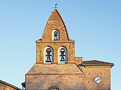 Bell gable
 -
 Post office


See also edit
References edit
- ^ "Répertoire national des élus: les maires". data.gouv.fr, Plateforme ouverte des données publiques françaises (in French). 2 December 2020.
- ^ "Populations légales 2021". The National Institute of Statistics and Economic Studies. 28 December 2023.
Wikimedia Commons has media related to Gragnague.