


Summary
Greenbank is a small informal district in the city of Bristol, England, nestling between Easton to the west, Eastville to the north-east, Clay Bottom and Rose Green to the east, and Whitehall to the south. The area is mainly one of 1890s terraced housing with some present millennium housing on the north eastern edge of the cemetery. Nearly all of the housing is in the north-east of Easton electoral ward, though the road Greenbank View and the cemetery are in Eastville electoral ward.[1]
| Greenbank | |
|---|---|
 New housing on Greenbank Road | |
 Greenbank Location within Bristol | |
| OS grid reference | ST617747 |
| Unitary authority | |
| Ceremonial county | |
| Region | |
| Country | England |
| Sovereign state | United Kingdom |
| Post town | BRISTOL |
| Postcode district | BS |
| Dialling code | 0117 |
| Police | Avon and Somerset |
| Fire | Avon |
| Ambulance | South Western |
Bristol & Bath Railway Path edit
The Bristol & Bath Railway Path forms the north eastern boundary of Greenbank and provides a traffic free route not only the two miles into Bristol, but also 13 miles to Bath along one of the most scenic non-traffic cycle routes in the country. The Path is seen as being a valuable public asset by the people of Greenbank and other adjoining areas, with a 2008 campaign to stop it being used as a bus route garnering much local support. The Path also provides a valuable green haven in the form of a linear park in what is a very densely populated part of Bristol.
Schools edit
The area is well served with primary schools with Whitehall and May Park both being contiguous to Greenbank proper. The City Academy Bristol is within a few hundred meters down the Railway Path towards Lawrence Hill and Bristol Metropolitan College is only a mile toward Fishponds.
Greenbank Cemetery edit
In the far eastern corner of the cemetery are the memorials to the civilian dead of the Bristol Blitz of 1941. The area is very moving, with some graves containing the remains of three generations of Bristolians. Nearby lies a separate military cemetery with graves from British and Commonwealth servicemen, the graves of German Luftwaffe crew killed during the Bristol Blitz, and Italian Mariners killed in action. The cemetery was used as a location for the Trotter brothers' mother's grave in the last ever episode of Only Fools and Horses.
Buildings edit
There are a few distinctive buildings within the area:
- The Elizabeth Shaw chocolate factory (famous for its 'Famous Names' and 'Chocolate Crisp' brands)
- Chapel in Greenbank Cemetery [2]
- Greenbank Masjid, occupying a church building formerly used by the Castle Green United Reformed Church. Informally known as the "Lego Church", it was designed by Sir Frank Wills and built in 1902.
Development of Greenbank Chocolate Factory edit
The factory ceased chocolate production in 2006, since when various attempts have been made to secure planning permission and develop the site. In 2013 the factory passed into the hands of the Generator Group.[3] The local community has always been actively interested in any proposals,[4] and began to object in force when they discovered that a plan had been submitted to Bristol City Council on Christmas Eve 2014.
Gallery edit
-
 Elizabeth Shaw chocolate factory
 -
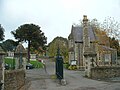 Greenbank Road entrance of Greenbank Cemetery
 -
 Balloon over Co-operation Road, Greenbank


References edit
- ^ "Easton Ward from May 2016 (map)" (PDF). Bristol City Council. 2016. Retrieved 18 February 2017.
- ^ "Cemeteries and crematoria". Bristol City Council. Retrieved 9 September 2016.
- ^ "Stressed or Distressed?". Generator Group. Retrieved 9 September 2016.
- ^ "ChocBox 2.0 community group for the Chocolate Factory, Greenbank". ChocBox 2.0 community group. Retrieved 9 September 2016.
External links edit
- St. Anne's Church, Greenbank
- A Short History of the Greenbank Chocolate Factory, John Penny (archived 2016)
- Chocbox2.0 - information compiled by local people about the Chocolate Factory and its future
- Aerial Shot of Greenbank, c. 1930, Map Your Bristol