


Summary
The Greenbrier River Trail (GRT),[1] is a lineal state park comprising a 77.1-mile (124.1 km) rail trail between North Caldwell and Cass in eastern West Virginia, United States.[2]
| Greenbrier River Rail Trail State Park | |
|---|---|
 Greenbrier River Trail south of Marlinton | |
 Location of Greenbrier River Trail's Marlinton Depot in West Virginia | |
| Location | Greenbrier County, West Virginia and Pocahontas County, West Virginia |
| Nearest town | Marlinton, West Virginia |
| Coordinates | 38°13′18″N 80°05′39″W / 38.22167°N 80.09417°W |
| Elevation | 2,116 ft (645 m) |
| Established | 1980 |
| Named for | Greenbrier River |
| Governing body | West Virginia Division of Natural Resources |
| Website | wvstateparks |
The GRT route and its contours were originally engineered by the Chesapeake and Ohio Railway, serving as a passenger and freight line before becoming unviable after the Great Depression. The right of way was gifted to the State of West Virginia in the late 1970s and the former railbed reopened in 1980[3] as a recreational multi-use trail.
The wheelchair-accessible trail features a hard-packed crushed-limestone surface[4] accommodating hiking, bicycling, ski-touring and horseback-riding. Access is provided at 14 trailheads.[4] The route features 16 primitive campsites (several with three-sided camping shelters),[5] 50 to 60 picnic tables,[6] and passes three state parks and two state forests.[5] As it follows the Greenbrier River, the trail drops 732 feet (223 m)[4] (north to south) along its route, crossing 35 trestles and traversing two tunnels – Droop Mountain Tunnel with a length of 409 feet (125 m) and Sharps Tunnel with a length of 500 feet (150 m).[7]
In 1999, the GRT was one of 50 trails in the United States designated a Millennium Legacy Trail.[8] In 2012, the trail was elected to the National Rail Trail Hall of Fame[6] and was named by Backpacker magazine as "one of the Top 10 hiking trails in the United States."[4]
Background edit
The GRT follows portions of the Chesapeake and Ohio Railway's former Greenbrier Division constructed between North Caldwell and Cass in 1899 and 1900. The route was used heavily in the 1920s for through traffic via its connection with the Western Maryland Railway at Durbin, serving quarries, sawmills and tanneries[9] as well as agricultural and livestock operations.[9] The line hit its peak peacetime tonnage in 1926.[9]
By the 1930s rail traffic waned, with the coming of improved roads[10] and the depletion of timber tracts.[9] Passenger service ended January 8, 1958,[9] and freight service ended in December 1978,[11] with the line being officially abandoned December 29, 1978.[10]
The Chesapeake and Ohio donated most of its right-of-way south of Durbin, including the land that became the Greenbrier River Trail, to the State of West Virginia on June 20, 1980.[10] A contractor for the railroad removed the track south of Cass in 1979–1980 and the state purchased the track from Cass to Durbin for its scrap value to be used by the Cass Scenic Railroad.[10]
-
 Marlinton trailhead
 -
 Straight shady section of trail
 -
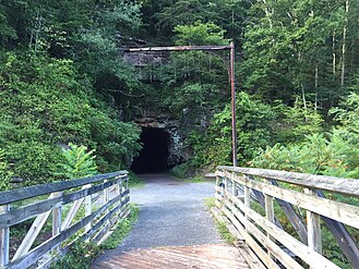 Southern entrance to Sharps Tunnel


Trailheads edit
| Trailhead | Milepost | Directions | Map Coordinates |
|---|---|---|---|
| North Caldwell | 3.0 | 1.3 mi (2.1 km) N of US 60 on Stone House Road | 37°47′37″N 80°22′50″W / 37.79361°N 80.38056°W |
| Harper | 5.8 | On CR 30/3 | |
| Keister | 11.1 | On CR 30/1 | |
| Anthony | 14.4 | On CR 21/2 | |
| Spring Creek | 21.4 | On CR 13, 3.5 mi (5.6 km) east of US 219 | |
| Renick | 24.5 | On Auto Road (CR 11), 0.4 mi (0.64 km) east of US 219 | |
| Horrock | 29.6 | On Rorer Road (CR 7/2) | |
| Beard | 38.5 | On Beard Post Office Road (CR 31/8) | |
| Burnsides | 41.7 | On Workman Road (CR 31/3) | |
| Seebert | 45.8 | at Seebert on Seebert Road (CR 27), about 2 miles (3.2 km) east of US 219 | 38°07′36″N 80°10′33″W / 38.12667°N 80.17583°W |
| Marlinton | 56.0 | at Marlinton on WV 39 | 38°13′18″N 80°05′39″W / 38.22167°N 80.09417°W |
| Cass | 80.4 | at Slabtown, 0.5 mi (0.80 km) S of Cass on WV 66 at Deer Creek Road | 38°23′27″N 79°55′20″W / 38.39083°N 79.92222°W |
See also edit
References edit
- ^ "Flood damage closes part of Greenbrier River Trail; all other West Virginia state parks fully operational". West Virginia Department of Natural Resources.
- ^ Greenbrier River Trail State Park web site, accessed April 19 2008
- ^ "Greenbrier River Trail at WVencyclopedia". WVencyclopedia.
- ^ a b c d Bob Downing (June 7, 2012). "Greenbrier River Trail great for W.Va. bikers, hikers". Charlotte Observer.
- ^ a b Karen M. Laski (August 1, 1997). "The Trails Less Traveled". Washington Post.
- ^ a b "Greenbrier River Trail Makes Hall of Fame". Allegheny Mountain Radio. June 4, 2012.
- ^ McNeel, William P. "Greenbrier River." The West Virginia Encyclopedia. Ken Sullivan, editor. Charleston, WV: West Virginia Humanities Council. 2006. ISBN 0-9778498-0-5
- ^ "Greenbrier River Trail: History". Greenbrier River Trail.
- ^ a b c d e "Greenbrier River Trail, West Virginia". Trail Link.
- ^ a b c d McNeel, William Price (1985). The Durbin Route. Charleston, West Virginia: Pictorial Histories Publishing Company. ISBN 0-933126-56-5.
- ^ "Greenbrier River Trail: 77 miles of lush history". The Roanoke Times. January 31, 1998.
- ^ "Greenbrier River Trail" (PDF). Greenbrier River Trail. West Virginia Division of Natural Resources. Retrieved June 12, 2017.
External links edit
- Official website
- Greenbrier River Trail Association web page
- West Virginia Rails-to-Trails page
- Hiking and Biking Map of the Greenbrier River Trail
- Greenbrier River Watershed Association
- Greenbrier River Trail at Trailink
- HawkinsRails Greenbrier River Trail page