


Summary
Grobbendonk (Dutch pronunciation: [ˈɣrɔbə(n)dɔŋk]) is a municipality located in the Belgian province of Antwerp (Dutch: Antwerpen). The municipality comprises the towns of Bouwel and Grobbendonk proper. In 2021, Grobbendonk had a total population of 11,249. The total area is 28.36 km2.[2]
Grobbendonk | |
|---|---|
 | |
 Flag  Coat of arms | |
Location of Grobbendonk .mw-parser-output .locmap .od{position:absolute}.mw-parser-output .locmap .id{position:absolute;line-height:0}.mw-parser-output .locmap .l0{font-size:0;position:absolute}.mw-parser-output .locmap .pv{line-height:110%;position:absolute;text-align:center}.mw-parser-output .locmap .pl{line-height:110%;position:absolute;top:-0.75em;text-align:right}.mw-parser-output .locmap .pr{line-height:110%;position:absolute;top:-0.75em;text-align:left}.mw-parser-output .locmap .pv>div{display:inline;padding:1px}.mw-parser-output .locmap .pl>div{display:inline;padding:1px;float:right}.mw-parser-output .locmap .pr>div{display:inline;padding:1px;float:left}html.skin-theme-clientpref-night .mw-parser-output .od,html.skin-theme-clientpref-night .mw-parser-output .od .pv>div,html.skin-theme-clientpref-night .mw-parser-output .od .pl>div,html.skin-theme-clientpref-night .mw-parser-output .od .pr>div{background:#000;color:#fff}html.skin-theme-clientpref-night .mw-parser-output .locmap{filter:grayscale(0.6)}@media(prefers-color-scheme:dark){html.skin-theme-clientpref-os .mw-parser-output .locmap{filter:grayscale(0.6)}html.skin-theme-clientpref-os .mw-parser-output .od,html.skin-theme-clientpref-os .mw-parser-output .od .pv>div,html.skin-theme-clientpref-os .mw-parser-output .od .pl>div,html.skin-theme-clientpref-os .mw-parser-output .od .pr>div{background:#000;color:#fff}}  Grobbendonk Location in Belgium
Location of Grobbendonk in the province of Antwerp  | |
| Coordinates: 51°12′N 04°43′E / 51.200°N 4.717°E | |
| Country | |
| Community | Flemish Community |
| Region | Flemish Region |
| Province | Antwerp |
| Arrondissement | Turnhout |
| Government | |
| • Mayor | Marianne Verhaert (GiB) |
| • Governing party/ies | Gib (local Open VLD), N-VA |
| Area | |
| • Total | 28.37 km2 (10.95 sq mi) |
| Population (2020-01-01)[1] | |
| • Total | 11,172 |
| • Density | 390/km2 (1,000/sq mi) |
| Postal codes | 2280, 2288 |
| NIS code | 13010 |
| Area codes | 014, 03 |
| Website | www.grobbendonk.be |
The official flag of Grobbendonk was adopted in 1989. In terms of heraldry, the flag is quartered, I and IV argent, three hills vert, a bird sable (specifically a raven), II and III gules three fleur-de-lis argent.
Lord of Grobbendonk edit
The house of Ursel is still lord of Grobbendonk, owner of the Heerlijkheid.
The heerlijkheid was in 1545 property of Erasmus II Schetz, the first Baron was his grandson Antonie II Schetz, Baron of Grobbendonck. The next generations were created Count of Grobbendonk, amongst these descendant duke of Ursel who was hereditary Count of Grobbendonk.
Famous inhabitants edit
- Rik Van Looy, cyclist, twice World Cycling Champion
- Herman Van Springel, cyclist, finished second in the Tour de France
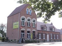
Gallery edit
-
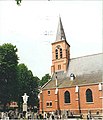 Assumption of Mary Church in Bouwel
 -
 Villa 't Wit Huys
 -
 Windmill Molen van Bouwel
 -
 Landscape near Grobbendonk


References edit
External links edit
 Media related to Grobbendonk at Wikimedia Commons
- Official website - Only available in Dutch