
KNOWPIA
WELCOME TO KNOWPIA

Gruchet-le-Valasse 
Summary
Gruchet-le-Valasse (French pronunciation: [ɡʁyʃɛ lə valas]) is a commune in the Seine-Maritime department of the Normandy region in northern France.
Gruchet-le-Valasse | |
|---|---|
 The abbey of Valasse, in 2004 | |
 Coat of arms | |
Location of Gruchet-le-Valasse .mw-parser-output .locmap .od{position:absolute}.mw-parser-output .locmap .id{position:absolute;line-height:0}.mw-parser-output .locmap .l0{font-size:0;position:absolute}.mw-parser-output .locmap .pv{line-height:110%;position:absolute;text-align:center}.mw-parser-output .locmap .pl{line-height:110%;position:absolute;top:-0.75em;text-align:right}.mw-parser-output .locmap .pr{line-height:110%;position:absolute;top:-0.75em;text-align:left}.mw-parser-output .locmap .pv>div{display:inline;padding:1px}.mw-parser-output .locmap .pl>div{display:inline;padding:1px;float:right}.mw-parser-output .locmap .pr>div{display:inline;padding:1px;float:left}html.skin-theme-clientpref-night .mw-parser-output .od,html.skin-theme-clientpref-night .mw-parser-output .od .pv>div,html.skin-theme-clientpref-night .mw-parser-output .od .pl>div,html.skin-theme-clientpref-night .mw-parser-output .od .pr>div{background:#000;color:#fff}html.skin-theme-clientpref-night .mw-parser-output .locmap{filter:grayscale(0.6)}@media(prefers-color-scheme:dark){html.skin-theme-clientpref-os .mw-parser-output .locmap{filter:grayscale(0.6)}html.skin-theme-clientpref-os .mw-parser-output .od,html.skin-theme-clientpref-os .mw-parser-output .od .pv>div,html.skin-theme-clientpref-os .mw-parser-output .od .pl>div,html.skin-theme-clientpref-os .mw-parser-output .od .pr>div{background:#000;color:#fff}}  Gruchet-le-Valasse  Gruchet-le-Valasse | |
| Coordinates: 49°33′25″N 0°29′08″E / 49.5569°N 0.4856°E | |
| Country | France |
| Region | Normandy |
| Department | Seine-Maritime |
| Arrondissement | Le Havre |
| Canton | Bolbec |
| Intercommunality | Caux Seine Agglo |
| Government | |
| • Mayor (2020–2026) | Didier Peralta[1] (UDI) |
| Area 1 | 14.2 km2 (5.5 sq mi) |
| Population (2021)[2] | 3,074 |
| • Density | 220/km2 (560/sq mi) |
| Time zone | UTC+01:00 (CET) |
| • Summer (DST) | UTC+02:00 (CEST) |
| INSEE/Postal code | 76329 /76210 |
| Elevation | 12–141 m (39–463 ft) (avg. 30 m or 98 ft) |
| 1 French Land Register data, which excludes lakes, ponds, glaciers > 1 km2 (0.386 sq mi or 247 acres) and river estuaries. | |
Geography edit
A village of forestry, farming and associated light industry situated in the Pays de Caux, some 15 miles (24 km) east of Le Havre, at the junction of the D173 and D9015 roads.
Heraldry edit
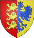 |
The arms of Gruchet-le-Valasse are blazoned : Gules, 3 leopards Or dimidiated with Or, a double-headed eagle crowned azure.
|
Population edit
| Year | Pop. | ±% p.a. |
|---|---|---|
| 1968 | 1,855 | — |
| 1975 | 1,819 | −0.28% |
| 1982 | 2,317 | +3.52% |
| 1990 | 2,787 | +2.34% |
| 1999 | 2,682 | −0.43% |
| 2007 | 2,544 | −0.66% |
| 2012 | 3,077 | +3.88% |
| 2017 | 3,160 | +0.53% |
| Source: INSEE[3] | ||
Places of interest edit
- Several sixteenth century houses.
- The church of St-Thomas, dating from the fourteenth century.
- The twelfth century abbey de Gruchet-le-Valasse.
- The nineteenth century Hôtel de Ville (town hall).
See also edit
References edit
- ^ "Répertoire national des élus: les maires" (in French). data.gouv.fr, Plateforme ouverte des données publiques françaises. 6 June 2023.
- ^ "Populations légales 2021". The National Institute of Statistics and Economic Studies. 28 December 2023.
- ^ Population en historique depuis 1968, INSEE
External links edit
Wikimedia Commons has media related to Gruchet-le-Valasse.
- Official website of Gruchet-le-Valasse (in French)