


Summary
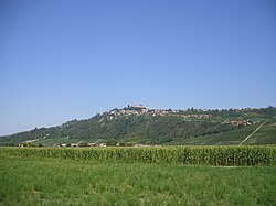
Guarene is a comune (municipality) in the Province of Cuneo in the Italian region Piedmont, located in the area of Roero about 45 kilometres (28 mi) southeast of Turin and about 50 kilometres (31 mi) northeast of Cuneo. It is one of I Borghi più belli d'Italia ("The most beautiful villages of Italy").[3]
Guarene | |
|---|---|
| Comune di Guarene | |
 | |
 Coat of arms | |
Location of Guarene .mw-parser-output .locmap .od{position:absolute}.mw-parser-output .locmap .id{position:absolute;line-height:0}.mw-parser-output .locmap .l0{font-size:0;position:absolute}.mw-parser-output .locmap .pv{line-height:110%;position:absolute;text-align:center}.mw-parser-output .locmap .pl{line-height:110%;position:absolute;top:-0.75em;text-align:right}.mw-parser-output .locmap .pr{line-height:110%;position:absolute;top:-0.75em;text-align:left}.mw-parser-output .locmap .pv>div{display:inline;padding:1px}.mw-parser-output .locmap .pl>div{display:inline;padding:1px;float:right}.mw-parser-output .locmap .pr>div{display:inline;padding:1px;float:left}html.skin-theme-clientpref-night .mw-parser-output .od,html.skin-theme-clientpref-night .mw-parser-output .od .pv>div,html.skin-theme-clientpref-night .mw-parser-output .od .pl>div,html.skin-theme-clientpref-night .mw-parser-output .od .pr>div{background:#000;color:#fff}html.skin-theme-clientpref-night .mw-parser-output .locmap{filter:grayscale(0.6)}@media(prefers-color-scheme:dark){html.skin-theme-clientpref-os .mw-parser-output .locmap{filter:grayscale(0.6)}html.skin-theme-clientpref-os .mw-parser-output .od,html.skin-theme-clientpref-os .mw-parser-output .od .pv>div,html.skin-theme-clientpref-os .mw-parser-output .od .pl>div,html.skin-theme-clientpref-os .mw-parser-output .od .pr>div{background:#000;color:#fff}}  Guarene Location of Guarene in Italy  Guarene Guarene (Piedmont) | |
| Coordinates: 44°44′N 8°2′E / 44.733°N 8.033°E | |
| Country | Italy |
| Region | Piedmont |
| Province | Cuneo (CN) |
| Frazioni | Bassi, Biano, Castelrotto, Montebello, Osteria, Racca, Vaccheria |
| Government | |
| • Mayor | Franco Artusio |
| Area | |
| • Total | 13.4 km2 (5.2 sq mi) |
| Elevation | 360 m (1,180 ft) |
| Population (31 May 2007)[2] | |
| • Total | 3,229 |
| • Density | 240/km2 (620/sq mi) |
| Demonym | Guarenesi |
| Time zone | UTC+1 (CET) |
| • Summer (DST) | UTC+2 (CEST) |
| Postal code | 12050 |
| Dialing code | 0173 |
| Patron saint | Saint James |
| Saint day | 25 July |
| Website | Official website |
It is part of the Roero historical region. Main sights include the castle (rebuilt in the 18th century), with Italian-style gardens, and the 17th century Palazzo Re Rebaudengo, now the seat of exhibitions.
Agriculture edit
The hilly parts of the commune are planted with vines and fruit trees. The principle grape varieties are Arneis, Nebbiolo, Dolcetto and Barbera. A wide variety of fruit in grown, but of particular note is the local “Madernassa” pear, a variety which originated here in 1784 and is currently enjoying an expanding export market, being particularly popular in England. Towards the Tanaro, in Frazione Vaccheria the crops include tomatoes, peppers, garlic and cardoons.[4]
References edit
- ^ "Superficie di Comuni Province e Regioni italiane al 9 ottobre 2011". Italian National Institute of Statistics. Retrieved 16 March 2019.
- ^ "Popolazione Residente al 1° Gennaio 2018". Italian National Institute of Statistics. Retrieved 16 March 2019.
- ^ "Piemonte" (in Italian). 9 January 2017. Retrieved 31 July 2023.
- ^ Comune Guarene: Agricoltura Archived 2007-03-12 at the Wayback Machine (in Italian)