
KNOWPIA
WELCOME TO KNOWPIA

Guilligomarc'h 
Summary
Guilligomarc'h (Breton: Gwelegouarc'h) is a commune in the Finistère department of Brittany in north-western France.
Guilligomarc'h
Gwelegouarc'h | |
|---|---|
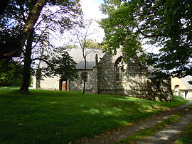 The chapel of Saint-Eloi, in Guilligomarc'h | |
Location of Guilligomarc'h .mw-parser-output .locmap .od{position:absolute}.mw-parser-output .locmap .id{position:absolute;line-height:0}.mw-parser-output .locmap .l0{font-size:0;position:absolute}.mw-parser-output .locmap .pv{line-height:110%;position:absolute;text-align:center}.mw-parser-output .locmap .pl{line-height:110%;position:absolute;top:-0.75em;text-align:right}.mw-parser-output .locmap .pr{line-height:110%;position:absolute;top:-0.75em;text-align:left}.mw-parser-output .locmap .pv>div{display:inline;padding:1px}.mw-parser-output .locmap .pl>div{display:inline;padding:1px;float:right}.mw-parser-output .locmap .pr>div{display:inline;padding:1px;float:left}html.skin-theme-clientpref-night .mw-parser-output .od,html.skin-theme-clientpref-night .mw-parser-output .od .pv>div,html.skin-theme-clientpref-night .mw-parser-output .od .pl>div,html.skin-theme-clientpref-night .mw-parser-output .od .pr>div{background:#000;color:#fff}html.skin-theme-clientpref-night .mw-parser-output .locmap{filter:grayscale(0.6)}@media(prefers-color-scheme:dark){html.skin-theme-clientpref-os .mw-parser-output .locmap{filter:grayscale(0.6)}html.skin-theme-clientpref-os .mw-parser-output .od,html.skin-theme-clientpref-os .mw-parser-output .od .pv>div,html.skin-theme-clientpref-os .mw-parser-output .od .pl>div,html.skin-theme-clientpref-os .mw-parser-output .od .pr>div{background:#000;color:#fff}}  Guilligomarc'h  Guilligomarc'h | |
| Coordinates: 47°56′13″N 3°24′52″W / 47.9369°N 3.4144°W | |
| Country | France |
| Region | Brittany |
| Department | Finistère |
| Arrondissement | Quimper |
| Canton | Quimperlé |
| Intercommunality | CA Quimperlé Communauté |
| Government | |
| • Mayor (2020–2026) | Alain Follic[1] |
| Area 1 | 22.75 km2 (8.78 sq mi) |
| Population (2021)[2] | 797 |
| • Density | 35/km2 (91/sq mi) |
| Time zone | UTC+01:00 (CET) |
| • Summer (DST) | UTC+02:00 (CEST) |
| INSEE/Postal code | 29071 /29300 |
| Elevation | 22–148 m (72–486 ft) |
| 1 French Land Register data, which excludes lakes, ponds, glaciers > 1 km2 (0.386 sq mi or 247 acres) and river estuaries. | |
Population edit
Inhabitants of Guilligomarc'h are called in French Guillogomarc'hois.
|
| ||||||||||||||||||||||||||||||||||||||||||||||||||||||||||||||||||||||||||||||||||||||||||||||||||||||||||||||||||
| Source: EHESS[3] and INSEE (1968-2020)[4] | |||||||||||||||||||||||||||||||||||||||||||||||||||||||||||||||||||||||||||||||||||||||||||||||||||||||||||||||||||
Geography edit
Guilligomarc'h is located in southeastern part of Finistère department, 13 km (8.1 mi) northeast of Quimperlé and 21 km (13 mi) north of Lorient. Historically, the village belongs to Vannetais. The river Ellé forms the commune's western border and the river Scorff its eastern border. Apart from the village centre, there are about seventy hamlets.
Neighboring communes edit
Map edit

List of hamlets edit
|
|
|
History edit
The oldest surviving parish registers date back to 1624.
Gallery edit
-
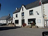 The town hall.
 -
 Sach castle.
 -
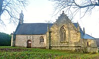 Saint Eloi's chapel.
 -
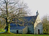 Saint Julien's chapel.
 -
 Thatched roof cottage in Saint-Eloi hamlet.
 -
 Old house in Saint Coal hamlet.


See also edit
References edit
- ^ "Répertoire national des élus: les maires". data.gouv.fr, Plateforme ouverte des données publiques françaises (in French). 2 December 2020.
- ^ "Populations légales 2021". The National Institute of Statistics and Economic Studies. 28 December 2023.
- ^ Des villages de Cassini aux communes d'aujourd'hui: Commune data sheet Guilligomarc'h, EHESS (in French).
- ^ Population en historique depuis 1968, INSEE
External links edit
Wikimedia Commons has media related to Guilligomarc'h.
- Official website (in French)
- Base Mérimée: Search for heritage in the commune, Ministère français de la Culture. (in French)
- Mayors of Finistère Association (in French)