


Summary
Gurap is a village in Dhaniakhali CD block in Chinsurah subdivision of Hooghly district in the state of West Bengal, India.
Gurap | |
|---|---|
Village | |
 | |
 Gurap Location in West Bengal, India  Gurap Gurap (India) | |
| Coordinates: 23°02′14″N 88°07′18″E / 23.037144°N 88.121556°E | |
| Country | |
| State | West Bengal |
| District | Hooghly |
| Elevation | 16 m (52 ft) |
| Population (2011) | |
| • Total | 7,856 |
| Languages | |
| • Official | Bengali, English |
| Time zone | UTC+5:30 (IST) |
| PIN | 712303 (Gurap) |
| Telephone/STD code | 03213 |
| Lok Sabha constituency | Hooghly |
| Vidhan Sabha constituency | Dhanekhali |
| Website | hooghly |
Geography edit


5miles
River
M: municipal corporation/ municipal city/ town, CT: census town, R: rural/ urban centre,
Owing to space constraints in the small map, the actual locations in a larger map may vary slightly
Location edit
The area is composed of flat alluvial plains that form a part of the Gangetic Delta.[1]
Police station edit
Gurap police station has jurisdiction over a part of Dhaniakhali CD block.[2][3]
Urbanisation edit
In Chandannagore subdivision 58.52% of the population is rural and the urban population is 41.48%. Chandannagore subdivision has 1 municipal corporation, 3 municipalities and 7 census towns. The single municipal corporation is Chandernagore Municipal Corporation. The municipalities are Tarakeswar Municipality, Bhadreswar Municipality and Champdany Municipality.[4] Of the three CD Blocks in Chandannagore subdivision, Tarakeswar CD Block is wholly rural, Haripal CD Block is predominantly rural with just 1 census town, and Singur CD Block is slightly less rural with 6 census towns. Polba Dadpur and Dhaniakhali CD Blocks of Chinsurah subdivision (included in the map alongside) are wholly rural.[5] The municipal areas are industrialised. All places marked in the map are linked in the larger full screen map.
Demographics edit
As per the 2011 Census of India, Gurap had a total population of 7,856 of which 3,880 (49%) were males and 3,976 (51%) were females. Population below 6 years was 748. The total number of literates in Gurap was 5,126 (72.12% of the population over 6 years).[5]
Transport edit
Gurap railway station is situated on the Howrah-Bardhaman chord.[6]
The Kolkata-Agra National Highway 19/Durgapur Expressway passes through Gurap.[7]
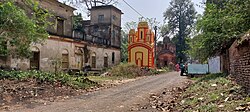
Culture edit
David J. McCutchion mentions the Nandadulala temple (1751) at Gurap as a standard atchala temple with porch on triple archway having leafy swathes. He mentions the dol-mancha (18th century) near the Nandadulala temple as having rich terracotta. There are porches on neo classical pillars later attached to the atchala.[8]
The temple of Nandadulala at Gurap (at Sr No S-WB-63) is included in the List of State Protected Monuments in West Bengal by the Archaeological Survey of India.[9][10]
-
 Nandadulala temple
 -
 Terracota decoration on the wall of Nanadulala temple
 -
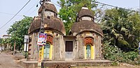 Jora Shiva Temple
 -
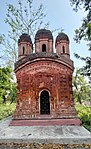 Pancharatna Shiva Temple


References edit
- ^ "District Census Handbook: Hugli, Series-20, Part XIIA" (PDF). Physiography, Page 17-24. Directorate of Census Operations, West Bengal, 2011. Retrieved 28 September 2018.
- ^ "District Statistical Handbook 2014 Hooghly". Tables 2.1, 2.2. Department of Statistics and Programme Implementation, Government of West Bengal. Retrieved 3 October 2018.
- ^ "Hooghly District Police". West Bengal Police. Retrieved 20 June 2017.
- ^ "District Statistical Handbook 2014 Hooghly". Table 2.1, 2.2, 2.4(a). Department of Statistics and Programme Implementation, Government of West Bengal. Retrieved 27 September 2018.
- ^ a b "C.D. Block Wise Primary Census Abstract Data(PCA)". 2011 census: West Bengal – District-wise CD Blocks. Registrar General and Census Commissioner, India. Retrieved 27 September 2018.
- ^ "36811 Howrah Bardhaman Jn Chord Local". Time Table. indiarailinfo. Retrieved 20 June 2017.
- ^ "Rationalisation of Numbering Systems of National Highways" (PDF). New Delhi: Department of Road Transport and Highways. Archived from the original (PDF) on 1 February 2016. Retrieved 20 June 2017.
- ^ McCutchion, David J., Late Mediaeval Temples of Bengal, first published 1972, reprinted 2017, pages 48, 73, 75. The Asiatic Society, Kolkata, ISBN 978-93-81574-65-2
- ^ "Protected Monuments in West Bengal". Archaeological Survey of India. Archived from the original on 3 September 2013. Retrieved 27 September 2020.
- ^ "Gurap: A Hidden Gem of Ancient Terracotta Works, Temples and More". Outlook India. Retrieved 18 March 2024.