


Summary
Haddinnet, also transliterated as Hadnet, is a tabia or municipality in the Dogu'a Tembien district of the Tigray Region of Ethiopia. The tabia centre is in Addi Idaga village, located approximately 6.5 km to the northeast of the woreda town Hagere Selam.
Haddinnet
Hadnet | |
|---|---|
Tabia | |
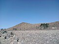
 Slopes of Tsili ridge in Haddinnet | |
 Haddinnet Location within Ethiopia | |
| Coordinates: 13°42′N 39°12′E / 13.700°N 39.200°E | |
| Country | Ethiopia |
| Region | Tigray |
| Zone | Debub Misraqawi (Southeastern) |
| Woreda | Dogu'a Tembien |
| Area | |
| • Total | 69.37 km2 (26.78 sq mi) |
| Elevation | 2,200 m (7,200 ft) |
| Population (2007) | |
| • Total | 7,310 |
| • Density | 105/km2 (270/sq mi) |
| Time zone | UTC+3 (EAT) |
Geography edit

The tabia is located on the southern and northern slopes of the Tsili ridge in the northern part of Dogu'a Tembien. The highest peak is Dabba Selama (2630 m a.s.l.) (not to be confounded with the homonymous monastery) and the lowest place along Agefet River (1720 m a.s.l.).


Geology edit


From the higher to the lower locations, the following geological formations are present:[1]
- Phonolite plugs
- Upper basalt
- Interbedded lacustrine deposits
- Lower basalt
- Amba Aradam Formation
- Agula Shale[2]
- Antalo Limestone
- Adigrat Sandstone
- Edaga Arbi Glacials
- Quaternary alluvium and freshwater tufa[3]
Climate edit
The rainfall pattern shows a very high seasonality with 70 to 80% of the annual rain falling in July and August. Mean temperature in Addi Idaga is 20.4 °C, oscillating between average daily minimum of 11.5 °C and maximum of 28.9 °C. The contrasts between day and night air temperatures are much larger than seasonal contrasts.[4]

Springs edit
As there is very poor baseflow in the permanent rivers, the presence of springs is of utmost importance for the local people. The main springs in the tabia are:[5]
- Ruba Weyni, fed by seepage from May Leiba reservoir
- May Damo in Atsa
- Abune Ayezgi in Debre Medhanit
Reservoirs edit
In this area with rains that last only for a couple of months per year, reservoirs of different sizes allow harvesting runoff from the rainy season for further use in the dry season. Overall they suffer from siltation.[6] Yet, they strongly contribute to greening the landscape, either through irrigation or seepage water. Main reservoirs are:
- May Leiba reservoir, in Ayninbirkekin tabia, constructed in 1998
- Traditional surface water harvesting ponds, particularly in places without permanent springs, called rahaya
- Horoyo, household ponds, recently constructed through campaigns[7]
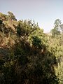
Vegetation and exclosures edit
The tabia holds several exclosures, areas that are set aside for regreening.[8] Wood harvesting and livestock range are not allowed there. Besides effects on biodiversity,[9][10][11] water infiltration, protection from flooding, sediment deposition,[12] carbon sequestration,[13] people commonly have economic benefits from these exclosures through grass harvesting, beekeeping and other non-timber forest products.[14] The local inhabitants also consider it as “land set aside for future generations”.[15]


Settlements edit
The tabia centre Addi Idaga holds a few administrative offices, a health post, a primary school, and some small shops. Saturday is the market day.[5] There are a few more primary schools across the tabia. The main other populated places are:[16]
|
|

Agriculture and livelihood edit
The population lives essentially from crop farming, supplemented with off-season work in nearby towns. The land is dominated by farmlands which are clearly demarcated and are cropped every year. Hence the agricultural system is a permanent upland farming system.[17] The farmers have adapted their cropping systems to the spatio-temporal variability in rainfall.[18] Large irrigated lands have been established in Addi Idaga. The youngsters of the tabia have established wide grasslands on mountain ridges; the grass is mainly sold for thatching.
History and culture edit

History edit
The history of the tabia is strongly confounded with the history of Tembien. In the 1930s, during the Italian invasion, Ksad Azef (13°44.2′N 39°13′E / 13.7367°N 39.217°E) was an important battlefield during the First Battle of Tembien. It is a place through which the Tembien highlands could relatively easily be accessed when coming from the Gheralta lowlands. The Italians called it Passo Abaro.[19] Italian Blackshirt soldiers left a memorial stone on top of the nearby Mount Dabba Selama.[20]

Religion and churches edit
Most inhabitants are Orthodox Christians. The following churches are located in the tabia:
|
|

Inda Siwa, the local beer houses edit
In the main villages, there are traditional beer houses (Inda Siwa), often in unique settings, which are a good place for resting and chatting with the local people. The most renown in the tabia are all located in the tabia centre Addi Idaga:[5]
- Yergalem Assefa
- Mulubrhan Hagos
- Mihret Abrha
Roads and communication edit

The main road Mekelle – Hagere Selam – Abiy Addi runs 5–10 km south of the tabia. People need to walk long distances to catch a bus. Further, a rural access road links most villages to the main asphalt road.
Tourism edit
Its mountainous nature and proximity to Mekelle makes the tabia fit for tourism.[21]
Touristic attractions edit
- Tsili ridge
- Tinsehe waterfall
- Dabba Selama mountain, with Erica arborea forest, church, and a memorial stone of the 1930s, left by soldiers of the Italian army, a metres-wide phonolite with inscriptions.[20]
- Kidane Mihret rock church in Ab'aro, surrounded by tufa plugs, springs and a cluster of trees. The church was established in widened caves of the tufa plug.[20]
Geotouristic sites edit
The high variability of geological formations and the rugged topography invites for geological and geographic tourism or "geotourism".[22] Geosites in the tabia include:
|
|
Birdwatching edit
Birdwatching (for the species, see the main Dogu'a Tembien page) can be done particularly in exclosures and forests. The Wehabit Sillasie church forest bird-watching site is particularly interesting.[9][16]

Trekking routes edit
Trekking routes have been established in this tabia.[20] The tracks are not marked on the ground but can be followed using downloaded .GPX files.[23]
- Trek 21, along the northern side of Tsaliet gorge up to Addi Hamushenai, and further down to Addeha in Kola Tembien
- Trek 23 to the top of Dabba Selama mountain
- Trek 26, over the top of Tsili ridge
- Trek Gh2, from Addi Idaga, down to Gheralta, along the Ab'aro rock church
Accommodation and facilities edit
The facilities are very basic.[24] One may be invited to spend the night in a rural homestead or ask permission to pitch a tent. Hotels are available in Hagere Selam and Mekelle.
More detailed information edit
For more details on environment, agriculture, rural sociology, hydrology, ecology, culture, etc., see the overall page on the Dogu'a Tembien district.
Gallery edit
-
 View on Azef
 -
 Dabba Selama Mountain
 -
 Ksad Azef Mountain Pass
 -
 Erica arborea on Dabba Selama Mountain


References edit
- ^ Sembroni, A.; Molin, P.; Dramis, F. (2019). Regional geology of the Dogu'a Tembien massif. In: Geo-trekking in Ethiopia's Tropical Mountains - The Dogu'a Tembien District. SpringerNature. ISBN 978-3-030-04954-6.
- ^ Bosellini, A.; Russo, A.; Fantozzi, P.; Assefa, G.; Tadesse, S. (1997). "The Mesozoic succession of the Mekelle Outlier (Tigrai Province, Ethiopia)". Mem. Sci. Geol. 49: 95–116.
- ^ Moeyersons, J. and colleagues (2006). "Age and backfill/overfill stratigraphy of two tufa dams, Tigray Highlands, Ethiopia: Evidence for Late Pleistocene and Holocene wet conditions". Palaeogeography, Palaeoclimatology, Palaeoecology. 230 (1–2): 162–178. Bibcode:2006PPP...230..165M. doi:10.1016/j.palaeo.2005.07.013.
- ^ Jacob, M. and colleagues (2019). "Dogu'a Tembien's Tropical Mountain Climate". Geo-trekking in Ethiopia's Tropical Mountains. GeoGuide. SpringerNature. pp. 45–61. doi:10.1007/978-3-030-04955-3_3. ISBN 978-3-030-04954-6. S2CID 199105560.
- ^ a b c What do we hear from the farmers in Dogu'a Tembien? [in Tigrinya]. Hagere Selam, Ethiopia. 2016. p. 100.
{{cite book}}: CS1 maint: location missing publisher (link) - ^ Nigussie Haregeweyn, and colleagues (2006). "Reservoirs in Tigray: characteristics and sediment deposition problems". Land Degradation and Development. 17: 211–230. doi:10.1002/ldr.698. S2CID 129834993.
- ^ Developers and farmers intertwining interventions: the case of rainwater harvesting and food-for-work in Degua Temben, Tigray, Ethiopia
- ^ Aerts, R; Nyssen, J; Mitiku Haile (2009). "On the difference between "exclosures" and "enclosures" in ecology and the environment". Journal of Arid Environments. 73 (8): 762–763. Bibcode:2009JArEn..73..762A. doi:10.1016/j.jaridenv.2009.01.006.
- ^ a b Aerts, R.; Lerouge, F.; November, E. (2019). Birds of forests and open woodlands in the highlands of Dogu'a Tembien. In: Geo-trekking in Ethiopia's Tropical Mountains - The Dogu'a Tembien District. SpringerNature. ISBN 978-3-030-04954-6.
- ^ Mastewal Yami, and colleagues (2007). "Impact of Area Enclosures on Density and Diversity of Large Wild Mammals: The Case of May Ba'ati, Douga Tembien Woreda, Central Tigray, Ethiopia". East African Journal of Sciences. 1: 1–14.
- ^ Aerts, R; Lerouge, F; November, E; Lens, L; Hermy, M; Muys, B (2008). "Land rehabilitation and the conservation of birds in a degraded Afromontane landscape in northern Ethiopia". Biodiversity and Conservation. 17: 53–69. doi:10.1007/s10531-007-9230-2. S2CID 37489450.
- ^ Descheemaeker, K. and colleagues (2006). "Sediment deposition and pedogenesis in exclosures in the Tigray Highlands, Ethiopia". Geoderma. 132 (3–4): 291–314. Bibcode:2006Geode.132..291D. doi:10.1016/j.geoderma.2005.04.027.
- ^ Wolde Mekuria, and colleagues (2011). "Restoration of Ecosystem Carbon Stocks Following Exclosure Establishment in Communal Grazing Lands in Tigray, Ethiopia". Soil Science Society of America Journal. 75 (1): 246–256. Bibcode:2011SSASJ..75..246M. doi:10.2136/sssaj2010.0176.
- ^ Bedru Babulo, and colleagues (2006). "Economic valuation methods of forest rehabilitation in exclosures". Journal of the Drylands. 1: 165–170.
- ^ Jacob, M. and colleagues (2019). Exclosures as Primary Option for Reforestation in Dogu'a Tembien. In: Geo-trekking in Ethiopia's Tropical Mountains - The Dogu'a Tembien District. SpringerNature. ISBN 978-3-030-04954-6.
- ^ a b Jacob, M. and colleagues (2019). Geo-trekking map of Dogu'a Tembien (1:50,000). In: Geo-trekking in Ethiopia's Tropical Mountains - The Dogu'a Tembien District. SpringerNature. ISBN 978-3-030-04954-6.
- ^ Nyssen, J.; Naudts, J.; De Geyndt, K.; Haile, Mitiku; Poesen, J.; Moeyersons, J.; Deckers, J. (2008). "Soils and land use in the Tigray highlands (Northern Ethiopia)". Land Degradation and Development. 19 (3): 257–274. doi:10.1002/ldr.840. S2CID 128492271.
- ^ Frankl, A. and colleagues (2013). "The effect of rainfall on spatio‐temporal variability in cropping systems and duration of crop cover in the Northern Ethiopian Highlands". Soil Use and Management. 29 (3): 374–383. doi:10.1111/sum.12041. hdl:1854/LU-3123393. S2CID 95207289.
- ^ Consociazione turistica Italiana. Guida dell'Africa orientale Italiana. Milano. p. 246.
- ^ a b c d Description of trekking routes in Dogu'a Tembien. In: Geo-trekking in Ethiopia's Tropical Mountains - The Dogu'a Tembien District. SpringerNature. 2019. ISBN 978-3-030-04954-6.
- ^ Geo-trekking in Ethiopia's Tropical Mountains - The Dogu'a Tembien District. SpringerNature. 2019. ISBN 978-3-030-04954-6.
- ^ Miruts Hagos and colleagues (2019). "Geosites, Geoheritage, Human-Environment Interactions, and Sustainable Geotourism in Dogu'a Tembien". Geo-trekking in Ethiopia's Tropical Mountains. GeoGuide. SpringerNature. pp. 3–27. doi:10.1007/978-3-030-04955-3_1. ISBN 978-3-030-04954-6. S2CID 199095921.
- ^ "Public GPS Traces tagged with nyssen-jacob-frankl".
- ^ Nyssen, Jan (2019). "Logistics for the Trekker in a Rural Mountain District of Northern Ethiopia". Geo-trekking in Ethiopia's Tropical Mountains. GeoGuide. Springer-Nature. pp. 537–556. doi:10.1007/978-3-030-04955-3_37. ISBN 978-3-030-04954-6. S2CID 199198251.