


Summary
Hadfield is a town in the High Peak of Derbyshire, England, with a population at the 2021 Census of 6,763.[1][2] It lies on the south side of the River Etherow, near to the border with Greater Manchester, at the western edge of the Peak District close to Glossop. It doubled as the fictional town of Royston Vasey in the BBC comedy series The League of Gentlemen.[3]
| Hadfield | |
|---|---|
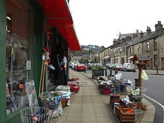 Station Road – The main street in Hadfield | |
 Hadfield Location within Derbyshire | |
| Population | 6,763 (2021 Census) |
| OS grid reference | SK021963 |
| District | |
| Shire county | |
| Region | |
| Country | England |
| Sovereign state | United Kingdom |
| Post town | GLOSSOP |
| Postcode district | SK13 |
| Dialling code | 01457 |
| Police | Derbyshire |
| Fire | Derbyshire |
| Ambulance | North West |
| UK Parliament | |
Geography edit
Hadfield is in the northwest of England, between Bottoms Reservoir and the Glossop Brook, on the southern side of the River Etherow valley, which is known as Longdendale. The town lies between 394 and 690 feet (120 and 210 m) above sea level. Hadfield is 12+1⁄2 miles (20 km) from Manchester.
History edit
Hadfield was part of the Manor of Glossop and, at the time of the Domesday Book in 1086, belonged to William the Conqueror.[4] King Henry I granted the land to William Peveril. In 1157, King Henry II gave it to the Abbey of Basingwerk in North Wales. In 1537, King Henry VIII gave it to the Earl of Shrewsbury, from whom it came to the Howard family (Dukes of Norfolk). While the Howards were responsible in the 1810s for the development of Glossop, it was the Sidebottom family who developed Hadfield. They bought the Waterside and Bridge Mill complex from John Turner and John Thornley in 1820.
For three generations, they developed these mills as a large spinning and weaving combine. They built their own branch railway to the mill and, in 1880, ran 293,000 spindles and 4,800 looms. In 1896, the Sidebottoms went into liquidation. Bridge Mill was destroyed by fire in 1899, but Waterside Mill was bought by John Gartside and Co of Ashton-under-Lyne. Gartside's re-equipped the mills with automatic looms from the United States and installed new engines and electric lighting.[5]
During the First World War (1914–18), the mill was taken over by the Greenfield Mill Company but parts of the mill were used to produce munitions. After the war, the company declined. In 1940, the mill was occupied by Maconochie's Foodstuffs Ltd, which had been bombed out of its previous premises in London. By 1954, about half of the original building had been demolished and more was to go. In 1976, the site was redeveloped and renamed as the Hadfield Trading Estate.[6]
Station Mill was built in 1834 by Thomas and Edward Platt, members of a family who had farmed Longdendale for generations. The family owned this cotton mill for 68 years, before selling it in 1923 to E. Wilman & Sons, which converted it to silk noil spinning. The mill closed in 1989.

Hadfield Mills were corn mills from before 1819. In 1874, Thomas Rhodes and Sons converted the mills to the manufacture of cotton. A thousand workers were employed there in 1873, but it closed in 1932. In 1940, it was reopened by Hadfield Worsted Mills Ltd for cloth manufacture.[6]
Hadfield and its mills were linked to Glossop via an electric tramway which operated between 1903 and 1927.
Governance edit
Hadfield is administered by High Peak Borough Council at the Town/District/Borough level of Government and by Derbyshire County Council at County level.
Representation on Derbyshire County Council is split between the divisions of Glossop and Charlesworth, and Etherow – with the majority of the town being in the Etherow division. The Etherow division contains Hadfield North, Hadfield South, Gamesley and the large and sparsely populated Tintwistle ward. The Glossop and Charlesworth division contains, amongst others, the Padfield ward (which takes the northern side of Station Road, the main shopping street). These boundaries were set in 2013.
| Division | Holder | |
|---|---|---|
| Etherow | Cllr Dave Wilcox | |
| Glossop and Charlesworth | Cllr Damien Greenhalgh Cllr Ellie Wilcox |
Representation on High Peak Borough Council
| Ward | Holder | |
|---|---|---|
| Hadfield North | Cllr MANN, Victoria Elizabeth | |
| Hadfield South | Cllr SIDDALL, Edward | |
| Hadfield South | Cllr MCKEOWN, Robert Joseph |
Hadfield does not have a parish council.
The Member of Parliament for the High Peak constituency, since 2019, has been Robert Largan MP who represents the Conservative Party. His majority in the 2019 general election was 590 over the Labour candidate Ruth George.
| Constituency | Holder | |
|---|---|---|
| High Peak | Robert Largan |
Transport edit
Hadfield lies within close proximity of the county boundary with Greater Manchester and some services are provided with this in mind. Though lying within Derbyshire and the East Midlands, some of Hadfield's transport facilities are managed by Transport for Greater Manchester.
Railway edit

The town is served by Hadfield and Dinting railway stations, on the Glossop line. Hadfield is the terminus, with most trains running first to Glossop and then reversing back through Dinting towards Manchester Piccadilly. Services are operated by Northern Trains.[9]
The railway, formerly known as the Woodhead Line, used to run through to Penistone and Sheffield, via the Woodhead Tunnel, but passenger services were withdrawn in 1970. Goods trains ran until 1981, when Hadfield became the terminus. The track to the east was lifted subsequently and has now been adopted as part of the Longdendale Trail footpath.
Roads edit
The A57, which links Manchester to Sheffield via the Snake Pass, passes to the south of Hadfield, from Woolley Bridge to Dinting Vale. The A628 road, from Manchester to Barnsley and Sheffield over the Woodhead Pass, runs on the other side of the River Etherow through Hollingworth and Tintwistle. These two roads are major freight routes and are often congested, which has created traffic problems both for Hadfield and the neighbouring towns and villages. The proposed Mottram to Tintwistle by-pass is intended to relieve the congestion.[10]
Buses edit
Bus services in the area are operated by Stagecoach Manchester and High Peak Buses. The town is served by three main bus routes:[11]
- 237, which runs twice per hour in each direction towards Glossop and Ashton-under-Lyne
- 341, which runs hourly to both Glossop and Hyde
- 393, which is an hourly circular route linking the town to Padfield, Glossop and Shirebrook Park.
Media edit
Regional TV news comes from Salford-based BBC North West and ITV Granada. Television signals are received from the Winter Hill,[12] and one of the two local relay transmitters (Glossop [13] and Mottram In Longdendale).[14]
Local radio stations are BBC Radio Manchester on 95.1 FM and Greatest Hits Radio Midlands (formerly High Peak Radio) on 106.4 FM.
The local newspaper is the Glossop Advertiser, owned by Manchester Evening News.[15]
Other media edit
The popular BBC television comedy series The League of Gentlemen was filmed in Hadfield, which doubled as the fictional town of Royston Vasey.[3] In the film spin-off from the original series, The League of Gentlemen's Apocalypse, Hadfield appears as itself when the characters from the TV series enter into the real world through a supposed portal below a church. The statue featured in the series and film's opening credits is the war memorial, commemorating lives lost in the First and Second World Wars.
See also edit
References edit
- ^ "Hadfield South Ward population 2011". Neighbourhood Statistics. Office for National Statistics. Archived from the original on 20 September 2016. Retrieved 25 March 2016.
- ^ "Hadfield North Ward population 2011". Neighbourhood Statistics. Office for National Statistics. Archived from the original on 20 September 2016. Retrieved 25 March 2016.
- ^ a b Allen, George (1 October 2017). "League of Gentlemen is being filmed in Derbyshire's Hadfield this month". Derbyshire Telegraph. Retrieved 25 January 2024.
- ^ Domesday Book: A Complete Translation. London: Penguin, 2003. ISBN 0-14-143994-7
- ^ Perkins, Helen. Old Ordnance Survey Maps Hadfield and Tintwistle 1907. Gateshead: Alan Godfrey Maps. ISBN 0-85054-647-8.
- ^ a b Quayle, Tom (2006). The Cotton Industry in Longdendale and Glossopdale. Stroud,Gloucestershire: Tempus. pp. 96–108. ISBN 0-7524-3883-2.
- ^ "Derbyshire County Council election results". 3 May 2013. Archived from the original on 6 May 2013.
- ^ High Peak councillors. Archived 26 January 2012 at the Wayback Machine
- ^ "Timetables and engineering information for travel with Northern". Northern Railway. 10 December 2023. Retrieved 27 December 2023.
- ^ "Work on £200m Mottram Pennine bypass 'could start in 2023'". BBC. 24 August 2020. Retrieved 6 November 2022.
- ^ "Hadfield Bus Services". Bus Times. 2023. Retrieved 27 December 2023.
- ^ "Full Freeview on the Winter Hill (Bolton, England) transmitter". UK Free TV. May 2004. Retrieved 19 September 2023.
- ^ "Freeview Light on the Glossop (Derbyshire, England) transmitter". UK Free TV. May 2004. Retrieved 6 November 2023.
- ^ "Freeview Light on the Mottram in Longdendale (Tameside, England) transmitter". UK Free TV. May 2004. Retrieved 6 November 2023.
- ^ "Glossop Advertiser". British Papers. 8 November 2013. Retrieved 6 November 2023.