


Summary
Hadley's Purchase is a township located in the southernmost portion of Coös County, New Hampshire, United States. As of the 2020 census, the purchase had a population of zero.[2] The purchase lies entirely within the White Mountain National Forest.
Hadley's Purchase, New Hampshire | |
|---|---|
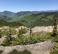 Northern half of Hadley's Purchase as seen from Mount Crawford. Crawford Notch in left distance, Mount Washington far right. | |
 Location in Coös County, New Hampshire | |
| Coordinates: 44°07′42″N 71°19′56″W / 44.12833°N 71.33222°W | |
| Country | United States |
| State | New Hampshire |
| County | Coös |
| Area | |
| • Total | 7.4 sq mi (19.2 km2) |
| • Land | 7.4 sq mi (19.2 km2) |
| • Water | 0 sq mi (0 km2) 0% |
| Elevation | 2,550 ft (780 m) |
| Population (2020)[2] | |
| • Total | 0 |
| Time zone | UTC-5 (Eastern) |
| • Summer (DST) | UTC-4 (Eastern) |
| Area code | 603 |
| FIPS code | 33-007-32420 |
| GNIS feature ID | 872009 |
In New Hampshire, locations, grants, townships (which are different from towns), and purchases are unincorporated portions of a county which are not part of any town and have limited self-government (if any, as many are uninhabited).
History edit
The purchase takes its name from Henry G. Hadley, who bought approximately 8,000 acres (32 km2) from the state in 1834 for $500.[3]
Geography edit
According to the United States Census Bureau, the purchase has a total area of 7.4 square miles (19.2 km2), all land other than streams. The highest point in the purchase is 3,180 feet (970 m) above sea level, along its eastern border. The highest summit in Hadley's Purchase is 3,119-foot (951 m) Mount Crawford, in the center of the purchase.
U.S. Route 302 in neighboring Hart's Location roughly parallels the southern and western limits of the purchase, passing within approximately 0.4 miles (0.64 km) to 1 mile (1.6 km) of the border.
Demographics edit
| Census | Pop. | Note | %± |
|---|---|---|---|
| 1960 | 0 | — | |
| 1970 | 0 | — | |
| 1980 | 0 | — | |
| 1990 | 0 | — | |
| 2000 | 0 | — | |
| 2010 | 0 | — | |
| 2020 | 0 | — | |
| U.S. Decennial Census[2][4] | |||
As of the 2010 census,[5] there were no people living in the township.
References edit
- ^ "2021 U.S. Gazetteer Files – New Hampshire". United States Census Bureau. Retrieved November 16, 2021.
- ^ a b c "Hadleys purchase, Coos County, New Hampshire: 2020 DEC Redistricting Data (PL 94-171)". U.S. Census Bureau. Retrieved November 16, 2021.
- ^ Julyan, Robert Hixson; Julyan, Mary (1993), Place Names of the White Mountains (Revised ed.), University Press of New England, p. 66, ISBN 978-0-87451-638-8
- ^ "Census of Population and Housing". Census.gov. Retrieved June 4, 2016.
- ^ "U.S. Census website". United States Census Bureau. Retrieved January 31, 2008.