


Summary
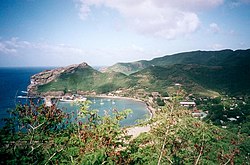
Hakahau is the main village and port of the island of Ua Pou, in the Marquesas Islands, northeast of French Polynesia. It is the capital of the municipality. It is located at the bottom of a sheltered bay on the northeast side of the island, and has a sheltered dock by a jetty. The Aranui 3 stops at Hakahau.[1]
Hakahau | |
|---|---|
Village | |
 | |
 Hakahau Location in the Marquesas Islands | |
| Coordinates: 9°21′40″S 140°2′57″W / 9.36111°S 140.04917°W | |
| Country | |
| Overseas collectivity | |
| Territory | |
| Island | Ua Pou |
| Area | |
| • Total | 4.333 km2 (1.673 sq mi) |
| Population | |
| • Total | 1,588 |
| • Density | 366/km2 (950/sq mi) |
Geography edit
Climate edit
Hakahau has a tropical monsoon climate (Köppen climate classification Am). The average annual temperature in Hakahau is 25.5 °C (77.9 °F). The average annual rainfall is 1,345.5 mm (52.97 in) with May as the wettest month. The temperatures are highest on average in March, at around 26.2 °C (79.2 °F), and lowest in September, at around 25.0 °C (77.0 °F). The highest temperature ever recorded in Hakahau was 32.1 °C (89.8 °F) on 13 April 2007; the coldest temperature ever recorded was 16.2 °C (61.2 °F) on 28 August 1997.
| Climate data for Hakahau (1991−2020 normals, extremes 1997−present) | |||||||||||||
|---|---|---|---|---|---|---|---|---|---|---|---|---|---|
| Month | Jan | Feb | Mar | Apr | May | Jun | Jul | Aug | Sep | Oct | Nov | Dec | Year |
| Record high °C (°F) | 31.5 (88.7) |
31.7 (89.1) |
31.6 (88.9) |
32.1 (89.8) |
31.6 (88.9) |
31.4 (88.5) |
30.7 (87.3) |
30.7 (87.3) |
31.0 (87.8) |
31.3 (88.3) |
31.4 (88.5) |
31.2 (88.2) |
32.1 (89.8) |
| Mean daily maximum °C (°F) | 28.6 (83.5) |
29.0 (84.2) |
29.3 (84.7) |
29.4 (84.9) |
29.2 (84.6) |
28.7 (83.7) |
28.2 (82.8) |
28.0 (82.4) |
28.1 (82.6) |
28.4 (83.1) |
28.4 (83.1) |
28.7 (83.7) |
28.7 (83.7) |
| Daily mean °C (°F) | 25.5 (77.9) |
25.9 (78.6) |
26.2 (79.2) |
26.1 (79.0) |
26.0 (78.8) |
25.6 (78.1) |
25.1 (77.2) |
25.0 (77.0) |
25.0 (77.0) |
25.2 (77.4) |
25.3 (77.5) |
25.5 (77.9) |
25.5 (77.9) |
| Mean daily minimum °C (°F) | 22.4 (72.3) |
22.9 (73.2) |
23.0 (73.4) |
22.9 (73.2) |
22.8 (73.0) |
22.4 (72.3) |
22.0 (71.6) |
22.0 (71.6) |
21.9 (71.4) |
22.0 (71.6) |
22.2 (72.0) |
22.4 (72.3) |
22.4 (72.3) |
| Record low °C (°F) | 18.0 (64.4) |
19.1 (66.4) |
18.1 (64.6) |
17.1 (62.8) |
17.4 (63.3) |
18.0 (64.4) |
17.1 (62.8) |
16.2 (61.2) |
16.4 (61.5) |
17.1 (62.8) |
17.7 (63.9) |
18.4 (65.1) |
16.2 (61.2) |
| Average precipitation mm (inches) | 152.5 (6.00) |
117.8 (4.64) |
186.5 (7.34) |
123.2 (4.85) |
114.2 (4.50) |
108.1 (4.26) |
128.2 (5.05) |
77.7 (3.06) |
64.0 (2.52) |
78.3 (3.08) |
117.4 (4.62) |
77.6 (3.06) |
1,345.5 (52.97) |
| Average precipitation days (≥ 1.0 mm) | 11.5 | 11.7 | 14.0 | 12.0 | 12.6 | 11.5 | 12.6 | 10.1 | 9.4 | 11.0 | 11.7 | 9.0 | 137.0 |
| Source: Météo-France[2] | |||||||||||||
References edit
- ^ Wheeler, Tony; Carillet, Jean-Bernard (1997). Tahiti & French Polynesia. Lonely Planet. p. 320. ISBN 978-0-86442-287-3.
- ^ "Fiche Climatologique Statistiques 1991-2020 et records" (PDF). Météo-France. Retrieved August 25, 2022.