


Summary
A haor (Bengali: হাওর[a]) is a wetland ecosystem in the north eastern part of Bangladesh which physically is a bowl or saucer shaped shallow depression, also known as a backswamp.[1][2][3][4][5] During monsoons haors receive surface runoff water from rivers and canals to become vast stretches of turbulent water.


Haor, baor, beel and jheel edit

In Bangladesh and in the deltaic part of the Indian state of West Bengal, which lie in the floodplain of three great rivers, the Bengali language has several terms to differentiate between lakes, including baor, haor, jheel and beel.[6][7] All four are types of similar freshwater wetlands.[8] The line of difference between a haor, a beel and a baor is usually very thin.
A beel is usually a depression or topographic low generally produced by erosion or other geographical process. These are marshy in character. Sometimes beels are remains of a river that has changed its course. Many of the beels dry up in the winter but during the rains expand into broad and shallow sheets of water, which may be described as fresh water lagoons.[9] Beels are generally smaller than haors, but there also are large beels like Chalan Beel in Rajshahi Division, through which the Atrai River passes. It has shrunk over the years but still occupies an area of 26 km2 in dry season. Sometimes small permanent water bodies within the haors remain after the haors dry up. These are also called beels, which occupy the lowest part of the depressions.[10][9] A baor or jheel is an oxbow lake,[11] namely moribund beds of Bhairab, Kaliganga, Gorai and Kumar rivers.[12]
A simple definition was provided by hydrologist Saila Parveen, "Haor – seasonal wetland, baor – oxbow lake, and beel – perennial water body."[13] Jheels or baors are found mostly in the moribund delta as in greater Comilla, Faridpur, Dhaka and Pabna districts.[3][9] The haor is predominantly a feature of north-eastern Bangladesh. Beels are seen all over Bangladesh and the neighboring districts of West Bengal.[14]
Geography and geology edit

In a country where one third of all area can be termed as wetlands,[15] the haor basin is an internationally important[citation needed] wetland ecosystem, spread over Sunamganj, Habiganj, Moulvibazar districts and Sylhet Sadar Upazila, as well as Kishoreganj and Netrokona districts outside the core haor area. It is a mosaic of wetland habitats, including rivers, streams and irrigation canals, large areas of seasonally flooded cultivated plains, and hundreds of haors and beels. This zone contains about 400 haors and beels, varying in size from a few hectares to several thousand hectares.[2][10][16]
The core haor area, alternatively referred to as the Haor basin or the Sylhet basin, is estimated to spread over an area between 4,450 km2[17] and 25,000 square kilometres[18] by experts. The total area of haor-type wetland ecosystem in Bangladesh is 80,000 square kilometres.[7] The haor basin is bounded by the hill ranges of India – Meghalaya on the north, Tripura and Mizoram on the south, and Assam and Manipur on the east.[10] The basin extends north to the foot of the Garo and Khasia Hills, and east along the upper Surma Valley to the Indian border. The Tippera surface lies directly to the south of the Haor Basin, and is partly low and deltaic and partly higher ground with a piedmont fringe to the east.[4] It includes about 47 major haors and some 6,300 beels of varying size, of which about 3,500 are permanent and 2,800 are seasonal.[5][10]
These area is low because of subsidence of tectonic Dauki fault.[12] In the geological depression of the haor basin, subsidence is continuing at an estimated rate of 20 mm per year. In some places it has sunk by around 10 m in the last few hundred years.[11] The area, by some experts, is further divided into three zones by standards of morphology and hydrology:[11]
Climate and floods edit

The haor basin is a remote and difficult area that is flooded every year during monsoon.[1][18]
Some of the most extensive seasonally flooded areas in South Asia are situated in bowl-shaped depressions known as haors located between the natural levees of rivers subject to overflow during the monsoon.[18] The major rivers in the area are Surma and Kushiyara. Some of the tributaries are: Manu, Khowai, Jadukhata, Piyain, Mogra, Mahadao and Kangsha. The hilly rivers coming down from the Khasi and Jaintia hills in Meghalaya carry particularly high volumes of water as they come from some of the rainiest places in the world.[19]
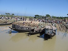
During July to November due to flood these areas go under deep water and look like seas with erosive water surface. During wind storm these waves reach up to 1.5 m in height.[1] It remains under water for seven months of the year, turning haor settlements mostly built on earthen mounds into islands.[1][20]
The fight against natural calamity of the locals people, mostly day laborers, relies on traditional and indigenous methods which with limited effect. Many villages have already been washed away, and many more are on the verge of extinction, forcing people to migrate to urban centers.[1]
Flora edit

The Haor Basin is the only region in Bangladesh where remnant patches of freshwater swamps and reed lands still exists.[2] Once extensive forests of Hijal in the area used to provide an important source of firewood, but these forests are now almost completely destroyed. In recent times, various herbs and aquatic plants are being collected for use as fuel. On top of that, aquatic plants are also being collected for use as fertilizers.[4] Only a few patches remain of the swamp forests that once dominated the area, featuring flood tolerant trees like Hijal (Barringtonia acutangula) and Koroch (Pongamia pinnata).[10]
Joseph Dalton Hooker (1817-1911) did the original survey of local flora sometime in 1850, recorded in his Himalayan Journals (published by the Calcutta Trigonometrical Survey Office and The Minerva Library of Famous Books; Ward, Lock, Bowden & Co., 1891).[21] The findings of his travels along the Surma and visiting the wetlands of Sylhet are reflected in his Flora of British India.[5] Three habitat types in the Sylhet region were identified on the basis of botanical records of Kanjilal (U.N. Kanjilal, P.C. Kanjilal & A. Das; Flora of Assam; 1934): Upland vegetation, Emergent vegetation, and Aquatic vegetation.[5]
The hijal or hual, korij or koroch, bhui dumur (Ficus heterophylla), nol (Arundo donax), khagra (Pharagmites karka), ban golap (Rosa involucratia) and barun (Crataeva nurvala) are the main plant species found in the swamp forests. All of them are flood-tolerant species and can survive in the submerged condition for extended periods of time. However, among these, hijal, tamal and koroj trees are of the greatest value to the people and the environment.[2] Other plant species available in the wetlands include madar (Erythrina variegata), gab (Diospyros peregrina), makna (Euryale ferox), singara (Trapa bispinosa), jaldumur (a kind of Ficus), chitki (Phyllanthus reticulatus), thankuni (Centella asiatica), kalmi (Ipomoea aquatica), helencha (Enhydra flactuans), hogla (Typha elephantina), duckweed, water hyacinth, lotus and water lily.[8]
Conservation edit
Three zones of international importance for conservation and sustainable utilization - the Meghna estuary, Tanguar haor and Hail-Hakaluki haors - have been declared as Ramsar sites under the Ramsar Convention for protection of wetlands, of which Bangladesh is a signatory.[22] The Bangladesh government has also declared the Tanguar haor an Ecologically Critical Area.[2] The Haor basin has a number of government bodies working to preserve the environment, including the Forest Resources Management Project, Management of Aquatic Ecosystem through Community Husbandry, Haor and Floodplain Resource, Conservation and Management of Medicinal Plants and Coastal and Wetland Biodiversity Management at Cox's Bazar and Hakaluki Haor.[23]
Human habitation edit


Prior to the 12th century there is almost no information available on the human habitation here. The information up to the 17th century is sketchy. During the British period, this area was not stringently surveyed, and not a lot of information is available.[24]
It is believed that the early settlers of the area were Hindus and other ethnic groups including Garo, Hajong, Khasi and Koch people coming down from the hills to the north. They were drawn to the area because of its productivity and favorable tenurial terms. With the expansion of Muslim power in the south and the west further Hindu migration continued in the 13th and 14th century. Following an Afghan defeat in Orissa in 1592, a large number of Afghans moved into the area. Expansion of Muslim population continued after the Muslim conquest of Sylhet in 1612, accelerating after the British conquest of Sylhet in 1765. By the 1770s all the cultivable land was brought under plough cultivation.[24]
From the 1780s, population and area under cultivation declined till early 20th century, mostly due to successive natural calamities including floods and earthquakes. The haor basin became an important fishing zone during this time. Population growth picked up again in the 20th century, again due to the opportunity to cultivate land for a nominal rent.[24]
In the haor region, villages are tightly nucleated and built on the natural levees (locally known as kandas). The haor villages are very large in size because no settlement can take place beyond the levees. During the dry cropping season, the satellite villages are established deep inside haor beds, far from parent villages. After harvesting and before inundation, the village structures are dismantled and transported back to parent villages along with harvests.[25]
Economy edit
These haors and beels support major subsistence and commercial fisheries, while the seasonally flooded lake margins support major rice-growing activities.[2] The main crop grown in the haor basin is boro rice or dry season rice. Early monsoon flash floods often cause extensive damage to the boro crop. Protection in the form of full flood dykes or submersible dykes is being provided in some of the developed areas.[11] Among the varieties of rice cultivated in winter, the Boro season, in the knee-deep water of marshlands, the Hashi (BR-17), the Shahjalal (BR-18) and the Mongol (BR-19) varieties are best suited for the haor areas.[12]
Haors and baors, along with the rivers, canals and the floodplain, are a major source of fish production. But, due to silting, and excessive harvesting of fish to meet the demand of growing populations production of fish from this source is gradually dwindling.[26] In recent years, the wetlands have also been used for rearing domestic ducks.[4]
Due to scarcity of cultivable land, government lands (khas land) including the wetlands are increasing getting transferred to private ownership in Bangladesh. Thus most of the haors and beels have now been sold or leased to private individuals for cultivation during the dry season. This transfer is governed by the Haor Development Board Ordinance (Ordinance No. IX of 1977) are under the direct control of the Revenue Department in the Ministry of Land Administration and Land Reforms.[4]
Tourism edit

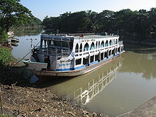
Haors are unique wetlands and have started attracting tourists. The best time to visit the haors is at the end of the monsoons, say around August–September, when they are full with water. Thereafter, the water in the haors starts receding but still provides an awe-inspiring sight. In winter, the haors and beels receive thousands of migratory birds.[10] It is the ideal season for bird-watchers, but then the haors are reduced in size and lose much of their watery grandeur. As summer sets in the haors are no more there, but one can still see numerous beels.
Lonely Planet describes these areas as "some of the most fascinating rural areas of Bangladesh."[27] According to the Ministry of Water Resources of Bangladesh, there were 144 of tourist spots in the Haor area in 2012, of which 37 were natural and 107 were manmade. The Ministry declared its aims to increase the current GDP rate of the tourism sector from 0.70 in 2012 to 2% by 2015 and then to 5% by 2021. 13 tourism development projects were declared including 2 eco-parks, 6 tourist spots, 3 nos of bird watching tower, a fish park, a wildlife sanctuary, and a tourist center near Hammam Waterfall including hotels, restaurants, and parking areas.[28] International Union for Conservation of Nature (IUCN) considers the increase in tourist traffic as "a potential opportunity for the haor dwellers for improving their livelihoods."[29] IUCN Bangladesh initiated a community-based tourism project in the Tanguar Haor wetland area (a Ramsar site) as one of the ways for sustainable management of wetland resources.[30]
Notes edit
- ^ Standard Bengali: [ɦao̯r]
Eastern dialects: [ɦaʊɹ]
Sylheti: [ɦáɔɹ]
References edit
- ^ a b c d e MK Alam; Wave attack in Haor areas of Bangladesh and cement concrete blocks as structural revetment material; Progress in Structural Engineering, Mechanics and Computation: Proceedings (ed. Alphose Zingoni); page 325; Taylor & Francis; 2004; ISBN 90-5809-568-1
- ^ a b c d e f Bio-ecological Zones of Bangladesh; International Union for Conservation of Nature and Natural Resources, Bangladesh Country Office; page 31; The World Conservation Union (IUCN); 2002; ISBN 984-31-1090-0
- ^ a b Bangladesh & Desertification Archived 2007-12-30 at the Wayback Machine, Sustainable Development Networking Programme (SDNP), Bangladesh; Retrieved: 2007-12-04
- ^ a b c d e Abdul Wahab Akonda (1989), "Bangladesh" (PDF), A directory of Asian wetlands, IUCN, pp. unpaginated, ISBN 2-88032-984-1
- ^ a b c d Bennett, Sara; Scott, Derek; Karim, Ansarul; Sobhan, Istiak; Khan, Anisuzzaman; Rashid, S.M.A. (1995). "Chapter 3: Interpretive Description of the Region's Wetlands". Wetland Specialist Study, Northeast Regional Water Management Plan, Bangladesh Flood Action Plan 6. Bangladesh Water Development Board. Archived from the original on 2008-08-07. Retrieved 2007-12-04.
- ^ Fikret Berkes; Sacred Ecology: Traditional Ecological Knowledge and Resource Management; page 43; Taylor & Francis; 1999; ISBN 1-56032-694-8
- ^ a b Overview Archived 2007-12-02 at the Wayback Machine, Official website of IUCN in Bangladesh; Retrieved: 2007-12-03
- ^ a b Alam, Mohd Shamsul; Hossain, Md Sazzad (2012). "Wetland". In Islam, Sirajul; Jamal, Ahmed A. (eds.). Banglapedia: National Encyclopedia of Bangladesh (Second ed.). Asiatic Society of Bangladesh.
- ^ a b c Alam, Mohd Shamsul; Hossain, Md Sazzad (2012). "Beel". In Islam, Sirajul; Jamal, Ahmed A. (eds.). Banglapedia: National Encyclopedia of Bangladesh (Second ed.). Asiatic Society of Bangladesh.
- ^ a b c d e f Alam, Mohd Shamsul; Hossain, Md Sazzad (2012). "Haor". In Islam, Sirajul; Jamal, Ahmed A. (eds.). Banglapedia: National Encyclopedia of Bangladesh (Second ed.). Asiatic Society of Bangladesh.
- ^ a b c d G. M. Akram Hossain, and Ainun Nishat. "Environmental Considerations for Water Resources Development in Haor Areas of Northeastern Bangladesh". American Society of Civil Engineers. Archived from the original on 2011-07-16. Retrieved 2007-11-23.
- ^ a b c Haque, M. Inamul (2012). "Haors_and_Wetlands". In Islam, Sirajul; Jamal, Ahmed A. (eds.). Banglapedia: National Encyclopedia of Bangladesh (Second ed.). Asiatic Society of Bangladesh.
- ^ Saila Parveen and Islam M Faisal, Open-water Fisheries in Bangladesh: A Critical Review Archived 2004-08-04 at the Wayback Machine, The Second International Symposium on the Management of Large Rivers for Fisheries, Large River Symposium
- ^ Chakraborty, Tapas Ranjan (2005). Management of Haors, Baors, and Beels in Bangladesh (PDF). International Lake Environment Committee Foundation.
- ^ Factsheet: Bird, Management of Aquatic Ecosystem through Community Husbandry, Government of Bangladesh; Retrieved: 2007-12-05
- ^ Khokon, Leaquat Hossain, 64 Jela Bhraman, 2007, p. 79, Anindya Prokash, Dhaka, ISBN 984-8740-19-8.
- ^ Alam, Mohd Shamsul (2012). "Depression3". In Islam, Sirajul; Jamal, Ahmed A. (eds.). Banglapedia: National Encyclopedia of Bangladesh (Second ed.). Asiatic Society of Bangladesh.
- ^ a b c Communities and forest management in South Asia; page 32; The World Conservation Union (IUCN); ISBN 2-8317-0554-1
- ^ Bandopadhyay, Dilip Kumar, Bharater Nadi (Rivers of India), 2002, (in Bengali), p. 78, Bharati Book Stall, 6B Ramanath Mazumdar Street, Kolkata
- ^ "Haor Rural Development Programme". concern.net. Archived from the original on 2007-07-09. Retrieved 2007-11-23.
- ^ Zuberi, M Iqbal (2012). "Flora". In Islam, Sirajul; Jamal, Ahmed A. (eds.). Banglapedia: National Encyclopedia of Bangladesh (Second ed.). Asiatic Society of Bangladesh.
- ^ Anwar, Jamal. "Migratory and other Birds in Bangladesh in Danger". SOS-arsenic.net. Retrieved 2007-11-27.
- ^ Convention on Biological Diversity Archived 2011-07-26 at the Wayback Machine, page 1, Department of Environment, Government of Bangladesh; Retrieved: 2007-12-05
- ^ a b c Soeftestad, Lars T. (31 May 2000). Riparian Right and Colonial Might in the Haors Basin of Bangladesh (PDF). International Association for the Study of Common Property (IASCP). Bloomington, Indiana. pp. 1–22. Archived from the original (PDF) on 10 June 2007.
- ^ Village, Banglapedia, Asiatic Society
- ^ National Fisheries Policy, Ministry Of Fisheries And Livestock, Government of Bangladesh, 1998; Retrieved: 2007-12-03
- ^ McAdam, Marika, Bangladesh, p. 149, Sunamganj, Lonely Planet, ISBN 1-74059-280-8
- ^ Master Plan of Haor Area, Bangladesh Haor and Wetland Development Board, Ministry of Water Resources
- ^ Community Based Sustainable Management of Tanguar Haor Project: 3rd Phase, International Union for Conservation of Nature (IUCN)
- ^ Promoting responsible tourism to develop climate resilient tourism industry, International Union for Conservation of Nature (IUCN)
Further reading edit
- Niyogi, PK (16 November 2008). "Travel: Water, Water everywhere". The Statesman. Kolkata.
External links edit
 Haor travel guide from Wikivoyage