
KNOWPIA
WELCOME TO KNOWPIA

Hargnies, Nord 
Summary
Hargnies (French pronunciation: [aʁɲi]) is a commune in the Nord department in northern France.[3]
Hargnies | |
|---|---|
 The town hall in Hargnies | |
 Coat of arms | |
Location of Hargnies .mw-parser-output .locmap .od{position:absolute}.mw-parser-output .locmap .id{position:absolute;line-height:0}.mw-parser-output .locmap .l0{font-size:0;position:absolute}.mw-parser-output .locmap .pv{line-height:110%;position:absolute;text-align:center}.mw-parser-output .locmap .pl{line-height:110%;position:absolute;top:-0.75em;text-align:right}.mw-parser-output .locmap .pr{line-height:110%;position:absolute;top:-0.75em;text-align:left}.mw-parser-output .locmap .pv>div{display:inline;padding:1px}.mw-parser-output .locmap .pl>div{display:inline;padding:1px;float:right}.mw-parser-output .locmap .pr>div{display:inline;padding:1px;float:left}html.skin-theme-clientpref-night .mw-parser-output .od,html.skin-theme-clientpref-night .mw-parser-output .od .pv>div,html.skin-theme-clientpref-night .mw-parser-output .od .pl>div,html.skin-theme-clientpref-night .mw-parser-output .od .pr>div{background:#000;color:#fff}html.skin-theme-clientpref-night .mw-parser-output .locmap{filter:grayscale(0.6)}@media(prefers-color-scheme:dark){html.skin-theme-clientpref-os .mw-parser-output .locmap{filter:grayscale(0.6)}html.skin-theme-clientpref-os .mw-parser-output .od,html.skin-theme-clientpref-os .mw-parser-output .od .pv>div,html.skin-theme-clientpref-os .mw-parser-output .od .pl>div,html.skin-theme-clientpref-os .mw-parser-output .od .pr>div{background:#000;color:#fff}}  Hargnies  Hargnies | |
| Coordinates: 50°15′28″N 3°50′55″E / 50.2578°N 3.8486°E | |
| Country | France |
| Region | Hauts-de-France |
| Department | Nord |
| Arrondissement | Avesnes-sur-Helpe |
| Canton | Aulnoye-Aymeries |
| Intercommunality | CC Pays de Mormal |
| Government | |
| • Mayor (2020–2026) | Alain Gerard[1] |
| Area 1 | 5.14 km2 (1.98 sq mi) |
| Population (2021)[2] | 626 |
| • Density | 120/km2 (320/sq mi) |
| Time zone | UTC+01:00 (CET) |
| • Summer (DST) | UTC+02:00 (CEST) |
| INSEE/Postal code | 59283 /59138 |
| Elevation | 137–162 m (449–531 ft) (avg. 146 m or 479 ft) |
| 1 French Land Register data, which excludes lakes, ponds, glaciers > 1 km2 (0.386 sq mi or 247 acres) and river estuaries. | |
Climate edit
In 2010, the commune's climate was classified as "semi-continental or mountain margin climate", according to the typology of climates in France, which at the time included eight major types of climate in mainland France. In 2020, the municipality was classified as having a "semi-continental climate" in the classification established by Météo-France, which now has only five main types of climate in mainland France. For this type of climate, the summers are hot and the winters harsh, with a large number of days of snow or frost. Annual rainfall is relatively high.[4]
Heraldry edit
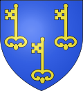 |
The arms of Hargnies are blazoned : Azure, 3 keys Or. (Floursies, Hargnies and Raismes use the same arms.)
|
See also edit
References edit
- ^ "Répertoire national des élus: les maires" (in French). data.gouv.fr, Plateforme ouverte des données publiques françaises. 13 September 2022.
- ^ "Populations légales 2021". The National Institute of Statistics and Economic Studies. 28 December 2023.
- ^ INSEE commune file
- ^ "Le climat en France métropolitaine". www.meteofrance.fr/ (in French). 4 February 2020. Retrieved 27 July 2021.
Wikimedia Commons has media related to Hargnies (Nord).