
KNOWPIA
WELCOME TO KNOWPIA

Harrington, New South Wales 
Summary
Harrington is a fishing village located on the northern entrance of the Manning River in New South Wales, Australia. It was established in 1853 and proclaimed a village on 26 September 1896. It is 15 km north-east of Taree[3] on the Mid North Coast, and 335 kilometres (208 mi) north east of the state capital, Sydney. At the 2021 census, Harrington had a population of 3,381.[1] It was named after the Earl of Harrington by the explorer, John Oxley.[3]
| Harrington New South Wales | |||||||||
|---|---|---|---|---|---|---|---|---|---|
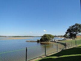 Manning River at Harrington | |||||||||
 Harrington | |||||||||
| Coordinates | 31°52′S 152°41′E / 31.867°S 152.683°E | ||||||||
| Population | 3,381 (2021 census)[1] | ||||||||
| Postcode(s) | 2427 | ||||||||
| Elevation | 6 m (20 ft)[2] | ||||||||
| Location |
| ||||||||
| LGA(s) | Mid-Coast Council | ||||||||
| State electorate(s) | Port Macquarie | ||||||||
| Federal division(s) | Lyne | ||||||||
| |||||||||
| Year | Pop. | ±% |
|---|---|---|
| 1966 | 543 | — |
| 1971 | 608 | +12.0% |
| 1976 | 896 | +47.4% |
| 1981 | 1,183 | +32.0% |
| 1986 | 1,234 | +4.3% |
| 1991 | 1,414 | +14.6% |
| 1996 | 1,397 | −1.2% |
| 2001 | 1,412 | +1.1% |
| 2006 | 1,753 | +24.2% |
| 2011 | 2,257 | +28.8% |
| 2016 | 2,896 | +28.3% |
| 2021 | 3,240 | +11.9% |
| Source: Australian Bureau of Statistics data.[4][5] | ||
Schools edit
- Harrington Public School[6]
Emergency Services edit
- Marine Rescue Crowdy Harrington
- SES
- RFS
References edit
- ^ a b Australian Bureau of Statistics (28 June 2022). "Harrington". 2021 Census QuickStats. Retrieved 13 March 2024.
- ^ Bureau of Meteorology. Retrieved on 2007-11-12.
- ^ a b "Harrington, New South Wales". Geographical Names Register (GNR) of NSW. Geographical Names Board of New South Wales. Retrieved 1 August 2013.
- ^ "Statistics by Catalogue Number". Australian Bureau of Statistics. Retrieved 24 January 2024.
- ^ "Search Census data". Australian Bureau of Statistics. Retrieved 24 January 2024.
- ^ "Home". harrington-p.schools.nsw.edu.au.
External links edit