


Summary
Harrowfield | |
|---|---|
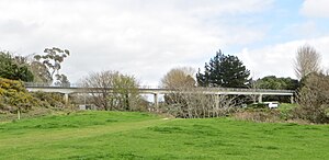 Sewer bridge over the Kirikiriroa Stream carries a walkway/cycleway linking Harrowfield with Queenwood | |
| Coordinates: .mw-parser-output .geo-default,.mw-parser-output .geo-dms,.mw-parser-output .geo-dec{display:inline}.mw-parser-output .geo-nondefault,.mw-parser-output .geo-multi-punct,.mw-parser-output .geo-inline-hidden{display:none}.mw-parser-output .longitude,.mw-parser-output .latitude{white-space:nowrap}37°44′30.5″S 175°15′31.67″E / 37.741806°S 175.2587972°E | |
| Country | New Zealand |
| City | Hamilton, New Zealand |
| Local authority | Hamilton City Council |
| Electoral ward | East Ward |
| Established | 1980s |
| Area | |
| • Land | 41 ha (101 acres) |
| Population (2018 Census)[2] | |
| • Total | 438 |
| St Petersburg | Flagstaff | Rototuna |
| Pukete |
|
Callum Brae |
| St Andrews | Beerescourt | Queenwood |
Harrowfield is a suburb in eastern Hamilton in New Zealand.[3] It was built in about 1991.[4][5]
Part of Tauhara Park borders the suburb. The park has a mini golf area, a playground, sports fields[6] and walkway/cycleway paths, which connect Harrowfield to the Kirikiriroa Stream valley, Queenwood and Flagstaff.[7] Some of the park, on the far side of Wairere Drive, covers the old Rototuna landfill. Since the late 1990s much of the leachate from the landfill has been collected for disposal at Pukete sewage works.[8] However residents were expressing concerns about it in 2012.[9]
Christmas lights in the suburb attract many visitors.[10]
In 2017 development of a further 22 dwellings, including 8 duplexes, was approved. Previous developments were on plots of around 1,200 m2 (13,000 sq ft), rather than the higher 320 m2 (3,400 sq ft) density of the new one, which backs on to Wairere Drive.[11]
Demographics edit
Harrowfield is marked on the 1:50,000 map[12] and is referred to as a suburb in its own right,[13] but as a census area it is part of Queenwood.[14]
| Year | Pop. | ±% p.a. |
|---|---|---|
| 2006 | 474 | — |
| 2013 | 471 | −0.09% |
| 2018 | 438 | −1.44% |
| Source: [2] | ||
Harrowfield had a population of 438 at the 2018 New Zealand census, a decrease of 33 people (−7.0%) since the 2013 census, and a decrease of 36 people (−7.6%) since the 2006 census. There were 165 households, comprising 222 males and 213 females, giving a sex ratio of 1.04 males per female, with 69 people (15.8%) aged under 15 years, 66 (15.1%) aged 15 to 29, 204 (46.6%) aged 30 to 64, and 102 (23.3%) aged 65 or older.
Ethnicities were 83.6% European/Pākehā, 8.2% Māori, 1.4% Pacific peoples, 14.4% Asian, and 0.7% other ethnicities. People may identify with more than one ethnicity.
Although some people chose not to answer the census's question about religious affiliation, 39.7% had no religion, 50.7% were Christian, 0.7% were Hindu, 1.4% were Buddhist and 0.7% had other religions.
Of those at least 15 years old, 132 (35.8%) people had a bachelor's or higher degree, and 24 (6.5%) people had no formal qualifications. 123 people (33.3%) earned over $70,000 compared to 17.2% nationally. The employment status of those at least 15 was that 180 (48.8%) people were employed full-time, 57 (15.4%) were part-time, and 12 (3.3%) were unemployed.[2]
Three SA1 statistical areas cover the Harrowfield suburb, with an area of 0.41 km2 (0.16 sq mi)[1] Their population was more stable, wealthier and older than the 37.4 years of the national average, as shown below -[15]
| meshblock 0952109 south/ SA1 7011948 |
0952108 centre/ SA1 7011947 |
0952107 north/ SA1 7011946 |
National median income | ||||||||||
|---|---|---|---|---|---|---|---|---|---|---|---|---|---|
| Year | Pop | Average age | Households | Median income | Pop | Average age | Households | Median income | Pop | Average age | Households | Median income | |
| 2001 | 204 | 43.1 | 63 | $27,900 | 129 | 44.5 | 45 | $32,000 | 156 | 38.3 | 54 | $35,000 | $18,500 |
| 2006 | 174 | 49 | 63 | $43,800 | 132 | 48 | 45 | $33,800 | 165 | 44 | 57 | $44,000 | $24,100 |
| 2013 | 168 | 53.3 | 66 | $43,800 | 117 | 50.2 | 45 | $36,700 | 186 | 47.5 | 63 | $33,800 | $27,900 |
| 2018 | 174 | 49.3 | 66 | $53,300 | 117 | 49.0 | 45 | $44,600 | 147 | 52.3 | 66 | $44,800 | $31,800 |
See also edit
References edit
- ^ a b "ArcGIS Web Application". statsnz.maps.arcgis.com. Retrieved 15 October 2022.
- ^ a b c "Statistical area 1 dataset for 2018 Census". Statistics New Zealand. March 2020. 7011946, 7011947 and 7011948.
- ^ "Hamilton Map". Hamilton City Council. Archived from the original on 23 September 2010. Retrieved 18 September 2010.
- ^ "Survey Number: SN9124 taken on 8/02/1991". retrolens.nz. Retrieved 5 April 2020.
- ^ "Topomap sheet S14". www.mapspast.org.nz. Retrieved 5 April 2020.
- ^ "Destination Parks". www.hamilton.govt.nz. Retrieved 5 April 2020.
- ^ "Gully Walk Maps-Tauhara Park" (PDF). Living Streets.
- ^ "Waste disposal sites". www.waikatoregion.govt.nz. Retrieved 5 April 2020.
- ^ "Resident suspects white liquid oozing from landfill". Stuff. Retrieved 5 April 2020.
- ^ Nicholson, Danielle. "Harrowfield lights up". NZ Herald. ISSN 1170-0777. Retrieved 5 April 2020.
- ^ "Duplex proposal for Hamilton's exclusive Harrowfield area perplexes neighbours". Stuff. Retrieved 5 April 2020.
- ^ "Rototuna, Waikato". NZ Topo Map. Retrieved 5 April 2020.
- ^ "Harrowfield Drive". ketehamilton.peoplesnetworknz.info. Retrieved 5 April 2020.
- ^ "ArcGIS Web Application". statsnz.maps.arcgis.com. Retrieved 5 April 2020.
- ^ "2013 Census map – QuickStats about a place". archive.stats.govt.nz. Retrieved 12 March 2020.