
KNOWPIA
WELCOME TO KNOWPIA

Haubourdin 
Summary
Haubourdin (French pronunciation: [obuʁdɛ̃]) is a commune in the Nord department in northern France. It is part of the Métropole Européenne de Lille.[3]
Haubourdin | |
|---|---|
 The church in Haubourdin | |
 Coat of arms | |
Location of Haubourdin .mw-parser-output .locmap .od{position:absolute}.mw-parser-output .locmap .id{position:absolute;line-height:0}.mw-parser-output .locmap .l0{font-size:0;position:absolute}.mw-parser-output .locmap .pv{line-height:110%;position:absolute;text-align:center}.mw-parser-output .locmap .pl{line-height:110%;position:absolute;top:-0.75em;text-align:right}.mw-parser-output .locmap .pr{line-height:110%;position:absolute;top:-0.75em;text-align:left}.mw-parser-output .locmap .pv>div{display:inline;padding:1px}.mw-parser-output .locmap .pl>div{display:inline;padding:1px;float:right}.mw-parser-output .locmap .pr>div{display:inline;padding:1px;float:left}html.skin-theme-clientpref-night .mw-parser-output .od,html.skin-theme-clientpref-night .mw-parser-output .od .pv>div,html.skin-theme-clientpref-night .mw-parser-output .od .pl>div,html.skin-theme-clientpref-night .mw-parser-output .od .pr>div{background:#000;color:#fff}html.skin-theme-clientpref-night .mw-parser-output .locmap{filter:grayscale(0.6)}@media(prefers-color-scheme:dark){html.skin-theme-clientpref-os .mw-parser-output .locmap{filter:grayscale(0.6)}html.skin-theme-clientpref-os .mw-parser-output .od,html.skin-theme-clientpref-os .mw-parser-output .od .pv>div,html.skin-theme-clientpref-os .mw-parser-output .od .pl>div,html.skin-theme-clientpref-os .mw-parser-output .od .pr>div{background:#000;color:#fff}}  Haubourdin  Haubourdin | |
| Coordinates: 50°36′35″N 2°59′16″E / 50.6097°N 2.9878°E | |
| Country | France |
| Region | Hauts-de-France |
| Department | Nord |
| Arrondissement | Lille |
| Canton | Faches-Thumesnil |
| Intercommunality | Métropole Européenne de Lille |
| Government | |
| • Mayor (2020–2026) | Pierre Beharelle[1] |
| Area 1 | 5.31 km2 (2.05 sq mi) |
| Population (2021)[2] | 14,757 |
| • Density | 2,800/km2 (7,200/sq mi) |
| Time zone | UTC+01:00 (CET) |
| • Summer (DST) | UTC+02:00 (CEST) |
| INSEE/Postal code | 59286 /59320 |
| Elevation | 17–35 m (56–115 ft) (avg. 23 m or 75 ft) |
| 1 French Land Register data, which excludes lakes, ponds, glaciers > 1 km2 (0.386 sq mi or 247 acres) and river estuaries. | |
Population edit
| Year | Pop. | ±% p.a. |
|---|---|---|
| 1968 | 12,106 | — |
| 1975 | 14,552 | +2.66% |
| 1982 | 14,497 | −0.05% |
| 1990 | 14,321 | −0.15% |
| 1999 | 14,965 | +0.49% |
| 2007 | 14,726 | −0.20% |
| 2012 | 14,498 | −0.31% |
| 2017 | 14,936 | +0.60% |
| Source: INSEE[4] | ||
Heraldry edit
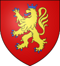 |
The arms of Haubourdin are blazoned : Gules, a lion Or, armed, langued and crowned azure. (Aix-en-Pévèle, Emmerin, and Haubourdin use the same arms.)
See also
edit
References edit
Wikimedia Commons has media related to Haubourdin.
|