


Summary
Hayrick Butte is a tuya, a type of subglacial volcano, in Linn County, Oregon. Located in the Willamette National Forest near Santiam Pass, it lies adjacent to the cinder cone Hoodoo Butte, which has a ski area. Hayrick Butte likely formed when lava erupted underneath an overlying glacier or ice sheet, producing the flat top with near-vertical walls along the ice-contact margin as the lava cooled and hardened. Hayrick Butte has a nearly flat plateau about 0.5 miles (0.80 km) across and steep walls rising about 700 feet (0.21 km) above its surroundings. A cartographer accidentally switched the names for nearby Hoodoo Butte and Hayrick Butte; the word "hoodoo" usually refers to rock piles and pinnacles like those observed at Hayrick Butte.
| Hayrick Butte | |
|---|---|
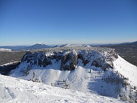 Hayrick Butte seen from the top of Hoodoo Ski Area | |
| Highest point | |
| Elevation | 5,482 ft (1,671 m)[1] |
| Prominence | 563 ft (172 m) |
| Coordinates | 44°23′57″N 121°52′17″W / 44.3992857°N 121.8714477°W[1] |
| Geography | |
 Hayrick Butte Location in Oregon | |
| Location | Linn County, Oregon, U.S. |
| Parent range | Cascades |
| Topo map | United States Geological Survey Three Fingered Jack |
| Geology | |
| Mountain type | Tuya |
Compared to Hoodoo, Hayrick is less popular for recreation, though it can be climbed, and there are hiking, snowshoeing, and snowmobile routes surrounding the butte. Its north-facing slope has subalpine forests with mountain hemlock and fir, which are common in the Cascades.
Geography edit
Hayrick Butte is located in Linn County in the U. S. state of Oregon.[1] Close to Santiam Pass,[2] it forms part of the United States Geological Survey topographic map for the Three Fingered Jack volcano.[1] Hayrick Butte lies south of Three Fingered Jack near Hoodoo Butte, Sand Mountain Field, Potato Butte, and Black Butte, with Belknap Crater and Mount Washington further to the south.[3] It is also within the McKenzie Ranger District of the Willamette National Forest.[4] According to the Geographic Names Information System, Hayrick Butte has an elevation of 5,482 feet (1,671 m);[1] in 1980, the Willamette National Forest Gazetteer listed its elevation as 5,575 feet (1,699 m).[4] The butte has a width of about 0.5 miles (0.80 km).[5]
Hayrick Butte is located next to the Hoodoo ski area.[6] In response to a new master plan at the Hoodoo Ski Bowl in 1995, the United States Forest Service released a draft environmental impact statement for the surroundings.[7] The Forest Service argued that development at Hoodoo Butte and Hayrick Butte would require excavating and/or blasting 20,000 to 28,000 cubic yards (15,000 to 21,000 m3) of soil and rock on Hayrick Butte, which would potentially exacerbate erosion of local soil.[8] The removal of this soil and rock would also substantially limit future revegetation, further reducing soil productivity in the area.[9] The Forest Service statement also asserted that development of new trails would not lead to significant "scenic resource effects,"[10] and that any "landform modification" from a proposed snow play area would only have moderate and short-term effects.[10]
Ecology edit
The Oregon Department of Fish and Wildlife determined in the early 1990s that there was potential for peregrine falcon nests at Hayrick Butte, though it was considered low-quality habitat because of its lack of suitable ledges and high amounts of human disturbance.[11] According to a 2003 paper, Hayrick Butte has a rich forest on its steep, north-facing slope with mountain hemlock and mature fir trees[12] at an elevation of 5,090 feet (1,550 m).[12][13] Oroboreal subalpine forests like these usually occur above elevations of 4,900 feet (1,500 m) in the Cascades, in areas with cool, wet climates. Mean precipitation for these zones ranges from 1,500 to 3,000 millimetres (59 to 118 in), with cool summers and cold, snowy winters. Dense forests are less common at higher elevations, switching to patchy forest stands separated from one another by shrubs or meadows.[14]
Geology edit
North Sister (of the Three Sisters volcano complex) and Mount Washington mark isolated volcanic centers among the highly mafic (rich in magnesium and iron) platform of the central High Cascade arc. About 4.5 million years ago, eruption of mafic lava filled a subsiding Pliocene depression, creating the modern, mafic High Cascades.[15] Compared to the eruptive products at and near North Sister, lava deposits at Mount Washington have a greater abundance of incompatible elements (elements unsuitable in size and/or charge to the cation sites of the minerals of which it is included.)[16] The nearby lava dome and tuya (subglacial volcano) Hogg Rock shows more similarity to the basaltic andesite deposits at North Sister, which are poorly enriched in incompatible elements.[17] The part of the High Cascades that extends south from Mount Jefferson to Santiam Pass includes shield volcanoes, lava domes, and cinder cones.[18] The high elevation of Matuyama-aged rocks east of Santiam Pass, coupled with exposure of Brunhes-aged rocks to the west, imply the presence of a northward-trending normal fault.[17]
Hayrick Butte is of late Pleistocene age.[19] Like Hogg Rock, Hayrick Butte is an andesite lava dome[20] with a flat top, suggesting that it is also a tuya, or a subglacial volcano. Both volcanic features have been eroded by glaciation,[2] leaving glassy margins and jointing.[21] Both Hayrick Butte and Hogg Rock produced porphyritic andesite lava with plagioclase and orthopyroxene and trace levels of phenocrysts with olivine.[22] Hayrick Butte also served as a barrier for Hoodoo Butte during the Pleistocene glaciation, blocking the advancement of glacial ice from eroding Hoodoo's summit crater.[20]
Most lava domes in the Cascades occur in clusters or surrounding just a few major volcanic centers. There are roughly 190 known domes in the state of Oregon, with 40 located near Mount Jefferson, 22 near the Tumalo volcanic highland, 28 near the Three Sisters, and close to 60 surrounding Mount Mazama. Hayrick Butte, however, is more isolated from other volcanoes.[23] Hayrick Butte, along with Benchmark Butte, formed more than 12 miles (20 km) from any major stratovolcano.[24] Hildreth (2007) likewise writes that Hayrick is "clearly separated from major clusters or evolved centers."[23]
Hayrick Butte has a normal magnetic polarity.[21] Like Hogg Rock and other andesite lava domes in the area, it has lower incompatible element abundances than surrounding andesitic rock deposits.[21] A 1992 element abundance analysis of Hayrick Butte andesite samples from the margin of the volcano shows a silicon dioxide (silica) level of 60.1 percent, aluminum oxide level of 18.4 percent, calcium oxide level of 6.24 percent, iron(II) oxide level of 5.55 percent, and sodium oxide level of 4.42 percent. Magnesium oxide made up 3.3 percent of the samples, with potassium oxide levels at 1.08 percent and manganese(II) oxide, phosphorus pentoxide, and titanium dioxide all below 1 percent.[25] Additional studies from 1980 and 1983 exhibit similar levels of silica in samples from Hogg Rock and Hayrick Butte at about 59[22] to 60 percent.[19]
Human history edit
According to cartographer Stuart Allen, an early cartographer[26] accidentally switched the names for nearby Hoodoo Butte and Hayrick Butte. The word "hoodoo" refers to rock piles and pinnacles like those observed at Hayrick Butte,[26] while "hayrick" is a synonym for haystack, a more fitting name for Hoodoo Butte, which has a profile that resembles a haystack shape. Whether or not this error actually occurred remains unclear, but the names remain to present day.[27]
Recreation edit
The Obsidian Climb School and Eugene Mountain Rescue offer climbing classes and field sessions at Hayrick Butte.[28] A backcountry, snowshoeing trail runs for 4 miles (6.4 km) from the Hoodoo ski area,[29] rising about 200 feet (61 m) in elevation over its course.[30] The route travels between Hayrick and Hoodoo Butte, offering views of Mount Washington.[31] There is an avalanche hazard near Hayrick's base.[31] An old roadbed next to the trail travels up Hoodoo Butte to the Hoodoo Butte Plateau[31] and the butte's summit,[32] where a historic fire cleared many trees.[32] There are snowmobile routes down the old Santiam Pass Wagon Road to the south and Forest Road 2690 to the east,[32] as well as a geocache at Hayrick's summit.[26] Markian Hawryluk of The Bulletin in Bend described Hayrick as "antisocial" compared to the "family-friendly ski area" of Hoodoo Butte,[26] citing its 700-foot (210 m) tall, nearly vertical walls.[26] The tuya is also surrounded by cliffs.[5] William Sullivan of The Register-Guard wrote that Hayrick offered "breathtaking views" of Mount Jefferson, Big Lake, Hoodoo Butte, Mount Washington, and Black Butte.[5] Hayrick Butte is also visible from the 6.9-mile (11.1 km) Patjens Lake Loop trail near Santiam Pass.[33]
References edit
- ^ a b c d e "Hayrick Butte". Geographic Names Information System. United States Geological Survey, United States Department of the Interior. November 19, 2018. Retrieved November 19, 2018.
- ^ a b Wood & Kienle 1990, p. 179.
- ^ Gannett 1903, p. 21.
- ^ a b Willamette National Forest Gazetteer 1980, p. 16.
- ^ a b c Sullivan, W. (December 7, 2010). "Island in the sky". The Register-Guard. GateHouse Media. Archived from the original on December 20, 2018. Retrieved December 20, 2018.
- ^ Hoodoo Master Plan 1995, p. IJ-68.
- ^ Hoodoo Master Plan 1995, p. S-1.
- ^ Hoodoo Master Plan 1995, p. 4-25.
- ^ Hoodoo Master Plan 1995, p. 4-26.
- ^ a b Hoodoo Master Plan 1995, p. 4-5.
- ^ United States Forest Service 1995, p. 15.
- ^ a b Rikkinen 2003b, p. 448.
- ^ Rikkinen 2003a, p. 9.
- ^ Rikkinen 2003a, p. 8.
- ^ Hughes & Taylor 1986, p. 1025.
- ^ Hughes & Taylor 1986, p. 1028.
- ^ a b Conrey et al. 2002, p. 62.
- ^ Wood & Kienle 1990, p. 178.
- ^ a b Hildreth 2007, p. 26.
- ^ a b Taylor 1981, p. 75.
- ^ a b c Hill & Priest 1992, p. 11.
- ^ a b Sherrod et al. 2004, p. 22.
- ^ a b Hildreth 2007, p. 45.
- ^ Hill 1991, p. 13.
- ^ Hill & Priest 1992, p. 12.
- ^ a b c d e Hawryluk, M. (March 10, 2011). "Tackling Hayrick Butte". The Bulletin. Western Communications. Archived from the original on December 20, 2018. Retrieved December 19, 2018.
- ^ Eisenbeis, C. (August 23, 2016). "Tuya: A distinctive local geological feature". Nugget Newspaper. Dolson, K. Archived from the original on February 12, 2018. Retrieved February 11, 2018.
- ^ The Obsidian Bulletin 2018, p. 4.
- ^ Andersen 2001, p. 107–109.
- ^ Andersen 2001, p. 107.
- ^ a b c Andersen 2001, p. 109.
- ^ a b c Andersen 2001, p. 110.
- ^ Sullivan, W. L. (October 25, 2018). "The post-fire parade yields stunning views at the Patjens Lakes". Statesman Journal. Gannett Company. Archived from the original on January 31, 2021. Retrieved December 20, 2018.
Sources edit
- Andersen, S. (2001). "Hayrick Butte". Snowshoe Routes: Oregon. The Mountaineers Books. pp. 107–109. ISBN 978-0898868333.
- "Chapter 3: Affected Environment", Willamette National Forest (N.F.), Hoodoo Master Plan, Linn County: Environmental Impact Statement, United States Forest Service, August 1995, archived from the original on 2021-01-31, retrieved 2018-12-17.
- Conrey, R. M.; Taylor, E. M.; Donnelly-Nolan, J. M.; Sherrod, D. R. (2002), Moore, G. W. (ed.), "North-central Oregon Cascades; exploring petrologic and tectonic intimacy in a propagating intra-arc rift" (PDF), Field guide to geologic processes in Cascadia; field trips to accompany the 98th annual meeting of the Cordilleran Section of the Geological Society of America, vol. 36, Oregon Department of Geology and Mineral Industries, pp. 47–90, archived (PDF) from the original on 2017-08-27, retrieved 2018-12-17.
- "Directory to Campgrounds, Picnic Areas, Mountains, Lakes, Rivers, Creeks and Prairies", Willamette National Forest Gazetteer, United States Forest Service, 1980, archived from the original on 2018-12-19, retrieved 2018-12-19.
- Gannett, H. (1903), "Forest conditions in the Cascade Range Forest Reserve, Oregon", in Langille, H. D.; Plummer, F. G.; Dodwell, A.; Rixon, T. F.; Leiberg, J. B. (eds.), Archived copy, 9, United States Geological Survey, pp. 15–26, doi:10.3133/pp9, hdl:027/hvd.32044102886108, Professional Paper 9, archived from the original on 2018-12-18, retrieved 2018-12-17
{{citation}}: CS1 maint: archived copy as title (link) - Harris, S. L. (2005). Fire Mountains of the West: The Cascade and Mono Lake Volcanoes (3rd ed.). Mountain Press Publishing Company. ISBN 978-0-87842-511-2.
- Hildreth, W. (2007), Quaternary Magmatism in the Cascades, Geologic Perspectives, United States Geological Survey, Professional Paper 1744, archived from the original on 2019-03-25, retrieved 2018-12-18.
- Hill, B. E. (1991). Petrogenesis of compositionally distinct silicic volcanoes in the Three Sisters region of the Oregon Cascade Range: the effects of crustal extension on the development of continental arc silicic magmatism (Thesis). Oregon State University. Archived from the original on 2018-12-19. Retrieved 2018-12-18.
- Hill, B. E.; Priest, G. R. (1992), Hill, B. E. (ed.), "Geologic setting of the Santiam Pass area, central Cascade Range, Oregon", Geology and geothermal resources of the Santiam Pass area of the Oregon Cascade Range, Deschutes, Jefferson, and Linn Counties, Oregon, Oregon Department of Geology and Mineral Industries, pp. 5–18, doi:10.2172/7018867, Open-File Report O-92-3, archived from the original on 2021-01-31, retrieved 2018-12-17.
- Hughes, S. S.; Taylor, E. M. (August 1986). "Geochemistry, petrogenesis, and tectonic implications of central High Cascade mafic platform lavas". GSA Bulletin. 97 (8). Geological Society of America: 1024–1036. Bibcode:1986GSAB...97.1024H. doi:10.1130/0016-7606(1986)97<1024:GPATIO>2.0.CO;2.
- "Obsidian Climb School at the Coburg Caves" (PDF), The Obsidian Bulletin, vol. 78, no. 3, The Obsidians, pp. 1–14, March 2018, archived (PDF) from the original on 2018-12-19, retrieved 2018-12-18.
- Rikkinen, J. (2003a). "Calicioid lichens and fungi in the forests and woodlands of western Oregon". Acta Botanica Fennica. 175. Finnish Zoological and Botanical Publishing Board: 1–41. ISSN 0001-5369. Archived from the original on 2021-01-31. Retrieved 2019-03-06.
- Rikkinen, J. (2003b). "New resinicolous ascomycetes from beaver scars in western North America". Annales Botanici Fennici. 40 (6). Finnish Zoological and Botanical Publishing Board: 443–450. ISSN 0003-3847. JSTOR 23726801.
- Sherrod, D. R.; Taylor, E. M.; Ferns, M. L.; Scott, W. E.; Conrey, R. M.; Smith, G. A. (2004), Geologic Map of the Bend 30- × 60-Minute Quadrangle, Central Oregon (PDF), United States Geological Survey, Geologic Investigations Series I–2683, archived from the original on 2019-01-07, retrieved 2016-04-30.
- Taylor, E. M. (1981), "Guides to Some Volcanic Terranes in Washington, Idaho, Oregon, and Northern California", in Johnston, D. A.; Donnelly-Nolan, J. (eds.), Road log for central High Cascade geology, Bend, Sisters, McKenzie Pass, and Santiam Pass, Oregon, Circular, pp. 59–83, doi:10.3133/cir838, Circular 838, archived from the original on 2018-11-14, retrieved 2018-12-17.
- Willamette National Forest (N.F.), Santiam Pass Forest Health Project, Linn County: Environmental Impact Statement, United States Forest Service, May 1995, archived from the original on 2021-01-31, retrieved 2018-12-17.
- Wood, C. A.; Kienle, J., eds. (1990). Volcanoes of North America: United States and Canada. Cambridge University Press. ISBN 978-0521438117.
External links edit
 Media related to Hayrick Butte at Wikimedia Commons