KNOWPIA
WELCOME TO KNOWPIA
Summary
53°22′01″N 2°08′24″W / 53.367°N 2.140°W
| Hazel Grove and Bramhall | |
|---|---|
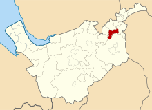
 Hazel Grove and Bramhall UD within Cheshire in 1970 | |
| Area | |
| • 1911 | 5,447 |
| • 1961 | 5,990 |
| Population | |
| • 1901 | 7,934 |
| • 1971 | 39,647 |
| History | |
| • Created | 1900 |
| • Abolished | 1974 |
| • Succeeded by | Metropolitan Borough of Stockport |
| Status | Urban district, Civil parish |
Hazel Grove and Bramhall was a civil parish[1] and urban district[2] in north east Cheshire, England from 1900 to 1974.
It was created in 1900 covering, from Stockport Rural District, the former area of the civil parishes of:
In 1936, 903 acres (3.65 km2) were transferred to the County Borough of Stockport and 16 acres (65,000 m2) to Marple Urban District. In 1939 the former area of the Woodford civil parish was gained.[2]
The district was abolished in 1974, under the Local Government Act 1972, and its former area was transferred to Greater Manchester to be combined with that of other districts to form the present-day Metropolitan Borough of Stockport.[3]
References edit
- ^ Vision of Britain Archived 2007-10-01 at the Wayback Machine - Hazel Grove and Bramhall parish (historic map Archived 2007-09-30 at the Wayback Machine)
- ^ a b Vision of Britain Archived 2007-09-30 at the Wayback Machine - Hazel Grove and Bramhall UD (historic map Archived 2007-10-01 at the Wayback Machine)
- ^ Arnold-Baker, C., Local Government Act 1972, (1973)


