
KNOWPIA
WELCOME TO KNOWPIA

Heart River (North Dakota) 
Summary
The Heart River is a tributary of the Missouri River, approximately 180 miles (290 km) long, in western North Dakota, United States.[1]
| Heart River | |
|---|---|
 The Heart River, near Mandan, North Dakota, 1949. | |
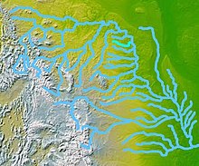 A map of the Missouri River watershed, highlighting the Heart River. | |
| Location | |
| Country | United States |
| State | North Dakota |
| Physical characteristics | |
| Source | Near Saddle Butte |
| • location | Belfield, Billings County |
| • coordinates | 46°56′13″N 103°13′49″W / 46.93694°N 103.23028°W[1] |
| • elevation | 2,740 ft (840 m) |
| Mouth | Missouri River |
• location | Mandan, Morton County |
• coordinates | 46°46′03″N 100°50′31″W / 46.76750°N 100.84194°W[1] |
• elevation | 1,624 ft (495 m) |
| Length | 180 mi (290 km) |
| Basin size | 3,370 sq mi (8,700 km2)[2] |
| Discharge | |
| • location | Mandan, about 3 mi (4.8 km) above the mouth[3] |
| • average | 269 cu ft/s (7.6 m3/s)[4] |
| • minimum | 0 cu ft/s (0 m3/s) |
| • maximum | 30,500 cu ft/s (860 m3/s) |
| Basin features | |
| Tributaries | |
| • left | Green River, Missouri River |
Course edit
The Heart River rises in the prairie country of Billings County, in the Little Missouri National Grassland near the south unit of Theodore Roosevelt National Park. It flows generally eastwardly through Stark County to Gladstone, past Belfield and South Heart, through the Patterson Reservoir and past Dickinson.
It is joined by the Green River at Gladstone, and turns east-southeastward into Grant County, passing through Lake Tschida, which is formed by the Heart Butte Dam. Below this dam, the river turns northeastward into Morton County, where it joins the Missouri River at Mandan.
See also edit
References edit
- ^ a b c U.S. Geological Survey Geographic Names Information System: Heart River
- ^ "Boundary Descriptions and Names of Regions, Subregions, Accounting Units and Cataloging Units". U.S. Geological Survey. Retrieved 2013-01-31.
- ^ "USGS Gage #06349000 on the Heart River near Mandan, ND" (PDF). National Water Information System. U.S. Geological Survey. 1924–2011. Retrieved 2013-01-31.
- ^ "USGS Gage #06349000 on the Heart River near Mandan, ND" (PDF). National Water Information System. U.S. Geological Survey. 1924–2011. Retrieved 2013-01-31.
External links edit
Wikimedia Commons has media related to Heart River (North Dakota).
- U.S. Geological Survey Geographic Names Information System: Heart River
- "The National Map Viewer". U.S. Geological Survey. Retrieved 2012-09-20.