


Summary
Hector is a cumulonimbus thundercloud cluster that forms regularly nearly every afternoon on the Tiwi Islands in the Northern Territory of Australia, from approximately September to March each year.[1][2][3] Hector, or sometimes Hector the Convector, is known as one of the world's most consistently large thunderstorms; specifically, a small mesoscale convective system (MCS) or large multicellular thunderstorm. It reaches heights of approximately 20 kilometres (66,000 ft).[4][5]

History edit
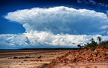
Named by pilots during the Second World War, the recurring position of the thunderstorm made it a navigational beacon for pilots and mariners in the region. A mesoscale phenomenon, Hector is caused primarily by a collision of several sea breeze boundaries across the Tiwi Islands and is known for its consistency and intensity.[6] Lightning flash rates and updraft speeds are notable aspects of this thunderstorm and during the 1990s National Geographic magazine published a comprehensive study of the storm with pictures of damaged trees and details of updraft speeds and references to tornadic events.[citation needed] The consistency of the phenomenon is caused by frequently occurring atmospheric conditions due to the sea and due to topography, and the underlying atmospheric environment constitutes a distinct microclimate (which are common with islands, especially ones exhibiting significant topographic relief).
Since the late 1980s the thunderstorm complex has been the subject of many meteorological studies, many centred on Hector itself,[4][7][8][9] but also utilising the consistency of the storm cell to study other aspects of thunderstorms, lightning, atmospheric boundaries, and marine and terrain effects on the atmosphere.
See also edit
References edit
- ^ The cloud called Hector. The Cloud Appreciation Society. Retrieved on 2010-11-30.
- ^ P. T. May; et al. (2009). "Aerosol and thermodynamic effects on tropical cloud systems during TWPICE and ACTIVE" (PDF). Atmos. Chem. Phys. 9 (1): 15–24. Bibcode:2009ACP.....9...15M. doi:10.5194/acp-9-15-2009.
- ^ Beringer, Jason; Tapper, Nigel J.; Keenan, Tom D. (2001). "Evolution of maritime continent thunderstorms under varying meteorological conditions over the Tiwi Islands" (PDF). International Journal of Climatology. 21 (8): 1021. Bibcode:2001IJCli..21.1021B. doi:10.1002/joc.622. S2CID 129777034. Archived from the original (PDF) on 1 March 2011. Retrieved 25 November 2010.
- ^ a b Crook, N. Andrew (1 June 2001). "Understanding Hector: The Dynamics of Island Thunderstorms". Monthly Weather Review. 129 (6): 1550–1563. Bibcode:2001MWRv..129.1550C. doi:10.1175/1520-0493(2001)129<1550:UHTDOI>2.0.CO;2.
- ^ "Hector arrives promptly at 3pm. But Hector isn't a person". CNN. 2 April 2022.
- ^ Beringer, Jason; Tapper, Nigel J.; Keenan, Tom D. (30 June 2001). "Evolution of maritime continent thunderstorms under varying meteorological conditions over the Tiwi Islands". International Journal of Climatology. 21 (8): 1021–1036. Bibcode:2001IJCli..21.1021B. doi:10.1002/joc.622. S2CID 129777034.
- ^ Barker, Anne (14 November 2005). "Researchers to investigate impact of storms". The World Today. Australian Broadcasting Corporation. Retrieved 11 July 2011.
- ^ Casben, Liv (14 February 2006). "Scientists complete storm study". PM. Australian Broadcasting Corporation. Retrieved 11 July 2011.
- ^ "Our changing atmosphere". Planet Earth Online. Natural Environment Research Council. 23 April 2007. Archived from the original on 6 October 2011. Retrieved 11 July 2011.
12°24′S 128°54′E / 12.4°S 128.9°E