
KNOWPIA
WELCOME TO KNOWPIA

Hermanville, Seine-Maritime 
Summary
Hermanville is a commune in the Seine-Maritime department in the Normandy region in north-western France.
Hermanville | |
|---|---|
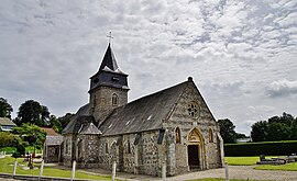 The church in Hermanville | |
 Coat of arms | |
Location of Hermanville .mw-parser-output .locmap .od{position:absolute}.mw-parser-output .locmap .id{position:absolute;line-height:0}.mw-parser-output .locmap .l0{font-size:0;position:absolute}.mw-parser-output .locmap .pv{line-height:110%;position:absolute;text-align:center}.mw-parser-output .locmap .pl{line-height:110%;position:absolute;top:-0.75em;text-align:right}.mw-parser-output .locmap .pr{line-height:110%;position:absolute;top:-0.75em;text-align:left}.mw-parser-output .locmap .pv>div{display:inline;padding:1px}.mw-parser-output .locmap .pl>div{display:inline;padding:1px;float:right}.mw-parser-output .locmap .pr>div{display:inline;padding:1px;float:left}html.skin-theme-clientpref-night .mw-parser-output .od,html.skin-theme-clientpref-night .mw-parser-output .od .pv>div,html.skin-theme-clientpref-night .mw-parser-output .od .pl>div,html.skin-theme-clientpref-night .mw-parser-output .od .pr>div{background:#000;color:#fff}html.skin-theme-clientpref-night .mw-parser-output .locmap{filter:grayscale(0.6)}@media(prefers-color-scheme:dark){html.skin-theme-clientpref-os .mw-parser-output .locmap{filter:grayscale(0.6)}html.skin-theme-clientpref-os .mw-parser-output .od,html.skin-theme-clientpref-os .mw-parser-output .od .pv>div,html.skin-theme-clientpref-os .mw-parser-output .od .pl>div,html.skin-theme-clientpref-os .mw-parser-output .od .pr>div{background:#000;color:#fff}}  Hermanville  Hermanville | |
| Coordinates: 49°49′14″N 0°59′21″E / 49.8206°N 0.9892°E | |
| Country | France |
| Region | Normandy |
| Department | Seine-Maritime |
| Arrondissement | Dieppe |
| Canton | Luneray |
| Intercommunality | CC Terroir de Caux |
| Government | |
| • Mayor (2020–2026) | Myriam Delaunay[1] |
| Area 1 | 4.72 km2 (1.82 sq mi) |
| Population (2021)[2] | 116 |
| • Density | 25/km2 (64/sq mi) |
| Time zone | UTC+01:00 (CET) |
| • Summer (DST) | UTC+02:00 (CEST) |
| INSEE/Postal code | 76356 /76730 |
| Elevation | 32–94 m (105–308 ft) (avg. 48 m or 157 ft) |
| 1 French Land Register data, which excludes lakes, ponds, glaciers > 1 km2 (0.386 sq mi or 247 acres) and river estuaries. | |
Geography edit
A small farming village situated by the banks of the Vienne river in the Pays de Caux, some 9 miles (14 km) southwest of Dieppe, at the junction of the D 108, D 123 and D 127 roads.
Heraldry edit
 |
The arms of Hermanville are blazoned : Argent, a fess azure between 3 roses gules, the fess charged with 3 charged bezants [Or] 1: a lion contourny, 2: a double-headed eagle and 3: a lion all sable voided.
|
Population edit
| Year | Pop. | ±% p.a. |
|---|---|---|
| 1968 | 119 | — |
| 1975 | 101 | −2.32% |
| 1982 | 110 | +1.23% |
| 1990 | 132 | +2.31% |
| 1999 | 111 | −1.91% |
| 2007 | 111 | +0.00% |
| 2012 | 108 | −0.55% |
| 2017 | 116 | +1.44% |
| Source: INSEE[3] | ||
Places of interest edit
- A seventeenth century manorhouse.
- The ruins of a feudal castle.
- The church of St.Martin, dating from the twelfth century.
- An old windmill, now converted to a residence.
- The statue of St. Patrick's Brewery.
See also edit
References edit
- ^ "Répertoire national des élus: les maires". data.gouv.fr, Plateforme ouverte des données publiques françaises (in French). 2 December 2020.
- ^ "Populations légales 2021". The National Institute of Statistics and Economic Studies. 28 December 2023.
- ^ Population en historique depuis 1968, INSEE
Wikimedia Commons has media related to Hermanville.