


Summary
Hermsdorf (German pronunciation: [ˈhɛʁmsˌdɔʁf] ⓘ) is a district (Ortsteil) of Berlin located in the borough (Bezirk) of Reinickendorf.
Hermsdorf | |
|---|---|
 Village church | |
 Coat of arms | |
Location of Hermsdorf in Reinickendorf district and Berlin 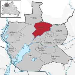 | |
 Hermsdorf  Hermsdorf | |
| Coordinates: 52°37′00″N 13°19′00″E / 52.61667°N 13.31667°E | |
| Country | Germany |
| State | Berlin |
| City | Berlin |
| Borough | Reinickendorf |
| Founded | 1200 |
| Area | |
| • Total | 6.1 km2 (2.4 sq mi) |
| Highest elevation | 65 m (213 ft) |
| Lowest elevation | 30 m (100 ft) |
| Population (2021-12-31)[1] | |
| • Total | 16,644 |
| • Density | 2,700/km2 (7,100/sq mi) |
| Time zone | UTC+01:00 (CET) |
| • Summer (DST) | UTC+02:00 (CEST) |
| Postal codes | (nr. 1206) 13467 |
| Vehicle registration | B |
History edit
First mentioned in 1200, it was an autonomous municipality merged into Berlin in 1920 with the "Greater Berlin Act". During the Cold War, as part of West Berlin bordering East Germany, it was crossed by the Berlin Wall from 1961 to 1989 at its border with the municipality of Glienicke/Nordbahn.[2]
Geography edit
It is situated in the north of the city, bordering the Brandenburger municipality of Glienicke/Nordbahn (Oberhavel district). It borders the Berliner localities of Frohnau, Tegel, Waidmannslust and Lübars. It also borders the forest of Tegel and part of its territory is included in Barnim Nature Park.[3]
Transport edit
Hermsdorf is served by the Berlin S-Bahn line S1 at the station Berlin-Hermsdorf.
Personalities edit
- Max Beckmann
- Hans Blüher
- Erich Kästner
- Gustav Landauer
- Annemarie Wolff-Richter
- Teomponk Simorangkir
References edit
Literature edit
External links edit
![]() Media related to Hermsdorf at Wikimedia Commons
Media related to Hermsdorf at Wikimedia Commons
- (in German) Hermsdorf page of Reinickendorfer website
- (in German) Hermsdorf on Kulturgeschichte Reinickendorf Wiki