


Summary
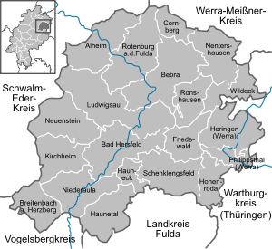
Hersfeld-Rotenburg is a Kreis (district) in the east of Hesse, Germany. Neighboring districts are Werra-Meißner, Wartburgkreis, Fulda, Vogelsbergkreis, Schwalm-Eder.
Hersfeld-Rotenburg | |
|---|---|
 Flag 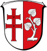 Coat of arms | |
 | |
| Country | Germany |
| State | Hesse |
| Adm. region | Kassel |
| Capital | Bad Hersfeld |
| Government | |
| • District admin. | Torsten Warnecke (SPD) |
| Area | |
| • Total | 1,097.08 km2 (423.58 sq mi) |
| Population (31 December 2022)[1] | |
| • Total | 121,566 |
| • Density | 110/km2 (290/sq mi) |
| Time zone | UTC+01:00 (CET) |
| • Summer (DST) | UTC+02:00 (CEST) |
| Vehicle registration | HEF, ROF |
| Website | http://www.hef-rof.de |
History edit
In 1821, districts were created in Hesse, including the districts Hersfeld and Rotenburg, which stayed nearly unchanged (except a short period after the revolution of 1848, when they were dissolved) through the annexion of Hesse-Kassel (or Hesse-Cassel) by Prussia and the creation of the Hesse state. In 1972 both districts were merged into one.
Geography edit
The district contains the hilly landscape of Waldhessen, the mountains are of the Knüllgebirge, Stölzinger Gebirge, Richelsdorfer Gebirge and the Kuppenrhön, part of the Rhön mountains.
Coat of arms edit
The coat of arms is a combination of the two coat of arms of the precursor districts. The cross in the left half is taken from the old arms of the Hersfeld abbey; the linden branch is taken from the city arms of Rotenburg.
Towns and municipalities edit
| Towns | Municipalities | |
|---|---|---|
Twin towns edit
References edit
- ^ "Bevölkerung in Hessen am 31.12.2022 nach Gemeinden" (XLS) (in German). Hessisches Statistisches Landesamt. June 2023.
External links edit
- Official website (in German)
- Touristic website (in German)
50°55′N 9°45′E / 50.92°N 9.75°E