
KNOWPIA
WELCOME TO KNOWPIA

Highway M04 (Ukraine) 
Summary
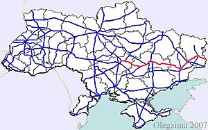
Highway M04 was a Ukraine international highway connecting Znamianka to Sorokyne on the border with Russia, where it continued into Russia as the A260.[1]
 | |
|---|---|
| Автошлях М04 | |
 | |
| Route information | |
| Part of | |
| History | Merged with the M12 to form the M30 |
| Major junctions | |
| West end | |
| East end | Russian border at Izvaryne |
| Location | |
| Country | Ukraine |
| Oblasts | Kirovohrad, Dnipropetrovsk, Donetsk, Luhansk |
| Highway system | |
In Soviet times the M04 was part of the M21. The highway stretched through four oblasts and ended at the Izvaryne-Donetsk border checkpoint which is part of Krasnodon city (Luhansk Oblast). The section from Znamianka to Debaltseve was part of European route E50, and the section from Debaltseve to the Russian border was part of European route E40. On 28 April 2021, the M04 was decommissioned and merged with the M12 to form the new M30.
War in Donbas edit
In eastern Ukraine, significant armed conflict has occurred along and near the M04 in the Donetsk and Luhansk Oblasts during the War in Donbass.
Route edit
| Marker | Main settlements | Notes | Highway Interchanges |
|---|---|---|---|
| 0 km | Znamianka | ||
| Oleksandriia | |||
| Chapaivka | |||
| Dnipro | |||
| Donetsk | |||
| Debaltseve | |||
| Luhansk | |||
| 566 km | Izvaryne / Border (Russia) |
Gallery edit
-
 M04 crossing Zhovta River near Piatykhatky, Dnipropetrovsk Oblast

See also edit
References edit
- ^ National Highways of Ukraine in Russian
External links edit
- National Roads in Ukraine in Russian