


Summary
Hindaun is a city and municipality, near city of Karauli in Karauli district, Rajasthan, India. It has a population of 105690 and is governed by a municipal council.
Hindaun City
| |
|---|---|
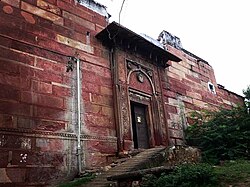
     Top to bottom: Nakkash Ki Devi - Gomti Dham, Jachcha Ki Baori, Jaggar Dam and Hindaun Fort (Purani Kachehri) and Shri Mahaveer Ji temple | |
| Nickname: Stone City | |
   | |
| Coordinates: 26°44′N 77°02′E / 26.74°N 77.03°E | |
| Country | |
| State | Rajasthan |
| District | Karauli |
| Tehsil | Hindaun Tehsil |
| Division | Bharatpur Division |
| Named for | Hiranya Kashyap and Hidimba |
| Government | |
| • Type | Democratic |
| • Body | Municipal Council |
| • Assembly constituency | Hindaun (Rajasthan Assembly constituency) |
| • MLA | Anita Jatav (INC) |
| • Chairman | Brijesh Jatav |
| • Rank | 1st in Karauli District (RJ) |
| Elevation | 235 m (771 ft) |
| Population (2011) | |
| • City | 105,690 |
| • Rank | 1st in Karauli District (RJ) |
| • Metro | 250,000 |
| Languages | |
| • Official | Hindi |
| • Native | Braj |
| • Native Boli | Jagroti (Sub language of Braj |
| Time zone | UTC+5:30 (IST) |
| PIN | 322230 |
| Telephone code | 91-7469 |
| Vehicle registration | RJ 34 |
| Sex ratio | 1000:889 ♂/♀ |
In the vicinity are the Aravalli and Vindhya mountainous ranges.
History edit
In the ancient time Hindaun came under the Matsya kingdom. There are many ancient structures still present in the town built during the regime of Matsya Kingdom. Traditionally in some mythological stories the town is believed to be associated with the mythology of Hiranyakashipu and Prahlada mentioned in Bhagavata Purana.
Hindaun is named after the name of ancient ruler king Hiranyakashipu, father of Prahlada. The temple to Narasimha, an Avatar of Hindu God Vishnu who killed Hiranyakashipu, along with the historic Prahalad Kund (now in dilapidated condition) demonstrates the town's connection to the mythology surrounding Hiranyakashipu and Prahlada.[1]
During the start of April 2018, Hinduan was subjected to curfew in response to caste-related violence.[2][3][4][5][6]
Location edit
Hindaun is located in the eastern part of Rajasthan, (a north-western state in India) in the vicinity of the Aravalli Range.
The town is well connected with Jaipur, Agra, Alwar, Dholpur, Bharatpur with modernized roads.
Hindaun has an average elevation of 235 metres (771 ft). Its distance from the state capital of Jaipur is around 150 km.
Industries edit
The city is known for its sandstone industry.[7] The Red Fort, Akshardham Temple of Delhi, and Ambedkar Park are made of this sandstone. The slate industry is well rooted here and is important in the state. Slate is transported abroad also. Various small-scale industries, e.g. candle, battis, wooden toys, and plastic water pipes, also exist.
Tourist attractions edit

The main places of attraction in Hindaun City are: The Prahladkund, forest, Hiranyakashayap ka kua, palace and the Narsinghji Temple, Shri Mahavirji Temple is a major pilgrimage center in Jainism. The Jaggar Dam of Jagar, Kundeva, Danghati, the Suroth Fort, City of Moradwaja, the castle of Garmora and Padampura, the Timangarh fort, Sagar Lake, Dhruv Ghata and the well of Nand-Bhaujai are some popular attractions. The temples of goddess Chamunda Mata Temple, Chinayata and Chamunda Mata Temple, Sankarghanta in western part of city, Nakkash Ki Devi - Gomti Dham (the heart temple of Hindaun City) with adjacent sacred pond termed as Jalsen pond. Radha-Raman Ji Temple and Shri Hardev Ji Temple are also famous and located within the city.[citation needed]

List of attractions edit

| Name | Location | Type | Period |
|---|---|---|---|
| Hindaun Fort | Purani Kachehri | Fortress | 14th century |
| Jachcha Ki Baori | Prahalad kund | Baoli/Bawdi(Stepwell) | 13th-15th century AD |
| Matiya Mahal | Near Prahalad kund | Place(Mahal) | 13th-15th century AD |
| Shri Mahavirji | Mahaveer ji | Temple | 17th century AD |
| Shri Raghunath Ji Temple | Old Hindaun | temple | 16th century AD |
| Nakkash Ki Devi - Gomti Dham | Gomti Dham | Temple | 20th century |
| Narsinghji Temple | Prahalad kund | temple | |
| Jaggar Dam | Jagar | Natural Dam & Hills | 1957 |
| Timangarh | Timan Garh | Fortress | 12th century |
Dargah of Sufi Saint Shaikh Abdur-Rehmaan Chishti is also at Hadoli. The shrine has the grave (Maqbara) of the revered saint, Shaikh Abdur - Rehmaan Chisti nephew of greatest sufi saint of India Moinuddin Chishti in Ajmer, Rajasthan.[citation needed]
| Year | Pop. | ±% |
|---|---|---|
| 1901 | 11,938 | — |
| 1911 | 10,640 | −10.9% |
| 1921 | 8,687 | −18.4% |
| 1931 | 10,825 | +24.6% |
| 1941 | 13,804 | +27.5% |
| 1951 | 14,673 | +6.3% |
| 1961 | 20,237 | +37.9% |
| 1971 | 27,895 | +37.8% |
| 1981 | 42,706 | +53.1% |
| 1991 | 60,780 | +42.3% |
| 2001 | 84,591 | +39.2% |
| 2011 | 105,690 | +24.9% |
| Source: Census of India[8] | ||
As per provisional reports of Census India the population of Hindaun in 2011 was 105,690; of which male and female are 49,541 and 56,149 respectively. The sex ratio of Hindaun is 881 per 1000 males.[9]
As per the census, the total number literates in the city is 105,690 of which 56,149 are males and 49,541 are females. Average literacy rate of Hindaun is 76.58 percent of which male and female literacy was 87.79 and 63.94 percent.
Total children (aged 0–6) in Hindaun are 45,451 as per figure from Census India report on 2011. There were 25,345 boys and 20,106 are girls. Child sex ratio of girls is 852 per 1000 boys.
Climate edit
Temperature in summer ranges between 25 and 45 degrees Celsius and in winter it is between 2 and 23 degrees Celsius. [10]
Agriculture edit
The land of the area is fertile and the crop rotation is commenced by the ryots. The central agriculture yard is located at Kyarda village opposite to 220kv power house. The major crops are wheat, millet, maize, mustard, cluster bean, ground nut, gooseberry, lemon potato, gram, barley. The monsoon, Jagar damand canal, wells and underground water are the source of irrigation. The seasonal vegetables and fruits are also sown by peasants.
Education edit
The city is famous for its Industrial Training Institutes. There are Teacher Training Institutes. Almost all district topper in RBSE Exams are from Hindaun City.[11]
Transportation edit
Roads edit
NH 47 (Indian National Highway No. 47) links Delhi To Mohana, MP by Delhi-Haryana-Rajasthan-Madhya Pradesh is announced by the central government in March 2016.
City transportation edit
Shared auto are operated between roadways bus stand and railway station. People use buses and auto-rickshaws to reach nearby places.
Railway edit
Hindaun City is a station on the New Delhi–Mumbai main line. Other railway stations in proximity to the city are Shri Mahabirji, Fateh Singhpura and Sikroda Meena[dhindhorahukmikheda]
Airport edit
Nearest major airport is Jaipur International Airport, that is 160 km from the city-centre, and offers sporadic service to major domestic and international locations.
See also edit
References edit
- ^ "Hindaun City". 14 September 2011. Retrieved 14 December 2017.
- ^ "Curfew-clamped in Hindaun after fresh-violence, 1200 held in state". Times of India. 4 April 2018. Retrieved 5 April 2018.
- ^ Parihar, Rohit (3 April 2018). "Curfew in Rajasthan's Hindaun after upper caste mob turns violent against Dalit protests". India Today. New Delhi. Retrieved 5 April 2018.
- ^ "Hinduan remains tense but peaceful". Times of India. 5 April 2018. Retrieved 5 April 2018.
- ^ Mukherjee, Deep. "At the receiving end in one Rajasthan town, Dalits say may embrace Islam". The Indian Express. Hinduan. Retrieved 5 April 2018.
- ^ "Bharat Bandh: Curfew imposed in Rajasthan's Hindaun". Business Standard. 4 April 2018. Retrieved 5 April 2018.
- ^ "Stone Industries of Karauli District". 21 February 2015. Retrieved 23 May 2015.
- ^ "TABLE 7.2.11". mospi.gov.in. Archived from the original on 13 August 2008. Retrieved 23 June 2008.
- ^ "Population of Hindaun". Retrieved 23 May 2015.
- ^ "Hindi ePaper, EPaper Download, Online Epaper, Newspaper in Hindi, Today Newspaper : Patrika".
- ^ "Almost all merits from Hindaun City in District, Result12th RBSE". 23 May 2015.