


Summary
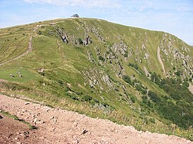
The Hohneck is, at 1,363 m (4,472 ft) the third highest summit of the Vosges Mountains (after Grand Ballon [1,424 m; 4,672 ft] and Storkenkopf [1,366 m; 4,482 ft]) and the highest point of Lorraine.[3] On its summit stands a mountain hut, clearly visible in the distance. Nearby the mountain's top is located the ski resort of La Bresse Hohneck.
| Hohneck | |
|---|---|
 The Hohneck | |
| Highest point | |
| Elevation | 1,363 m (4,472 ft)[1] |
| Prominence | 186 m (610 ft) |
| Isolation | 15.54 km (9.66 mi) |
| Coordinates | 48°02′15″N 7°00′59″E / 48.03750°N 7.01639°E[2] |
| Geography | |
 Hohneck France | |
| Location | Alsace, Lorraine; France |
| Parent range | Vosges Mountains |
Geography edit
The mountain is divided between the French municipalities of La Bresse (dep. of Vosges), Metzeral (department of Haut-Rhin) and Stosswihr (department of Haut-Rhin). A 1,289 m (4,229 ft) mountain, located 1.5 km (1 mi) east of the Hohneck, is named Petit Hohneck (in English Little Hohneck).
On a clear day from the Hohneck summit is possible to spot not just the entire Vosges range but also the Black Forest, the Jura, a good part of the Swiss Alps and, in the distance, the Mont Blanc.[4]
History edit

The Hohneck area has been up to the 19th century the main connection route between Gérardmer and Munster, before the opening of the col de la Schlucht road. Therefore, not faraway from the summit have been found ruins dating back to the Thirty Years' War and re-used during Napoleon's military champaigns.[5]
A tramway line from Gérardmer to the Hohneck operated between July 25, 1897, and August 28, 1939. From the Alsace side of the mountain a rack railway reached the Hohneck from Munster passing through the col de la Schlucht between 1907 and 1914.
Access to the summit edit

The well known Route des Crêtes (French for road of the peaks) transits not faraway from the top of the mountain, which can be reached by car following a small asphalted branch.
Bibliography edit
- Une Montagne vosgienne : le Hohneck, Guy-Jean Michel; Institut coopératif de l'École moderne, Imprimerie Merle et Cie, Grasse, 1963
- Guide du botaniste au Hohneck et aux environs de Géradmer, C. Brunotte and C. Lemasson, Coubé, 1921
- La Bresse-Le Hohneck, clins d'oeils sur l'histoire, Imprimerie Sailley, Le Thillot, 1995
External links edit
- Webcam on the mountain's top
See also edit
References edit
- ^ IGN maps available on Géoportail
- ^ "Hohneck, France" Peakbagger.com. Retrieved 2013-07-03.
- ^ France Region High Points, web-page on www.peakbagger.com
- ^ Route des Crêtes, web site frenchmoments.com
- ^ Pierre-Marie David, "Note sur les traces d'anciens réseaux de communication et les traces de retranchements dans le massif du Hohneck – Vosges", Bulletin de la Société Philomatique Vosgienne, 1991